Beaver Crossing Topo Map Nebraska
To zoom in, hover over the map of Beaver Crossing
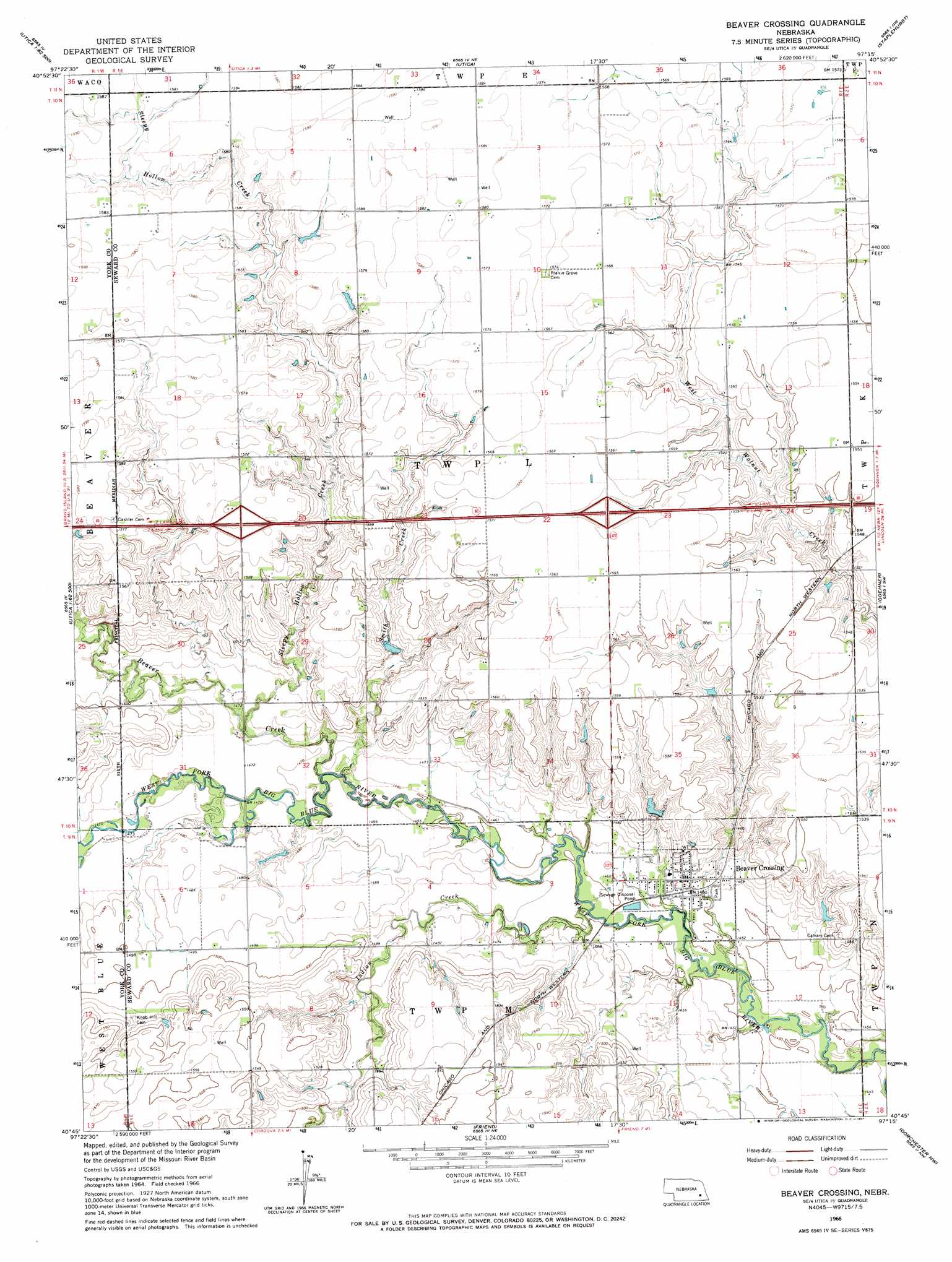
USGS Topo Quad 40097g3 - 1:24,000 scale
| Topo Map Name: | Beaver Crossing |
| USGS Topo Quad ID: | 40097g3 |
| Print Size: | ca. 21 1/4" wide x 27" high |
| Southeast Coordinates: | 40.75° N latitude / 97.25° W longitude |
| Map Center Coordinates: | 40.8125° N latitude / 97.3125° W longitude |
| U.S. State: | NE |
| Filename: | O40097g3.jpg |
| Download Map JPG Image: | Beaver Crossing topo map 1:24,000 scale |
| Map Type: | Topographic |
| Topo Series: | 7.5´ |
| Map Scale: | 1:24,000 |
| Source of Map Images: | United States Geological Survey (USGS) |
| Alternate Map Versions: |
Beaver Crossing NE 1966, updated 1967 Download PDF Buy paper map Beaver Crossing NE 2011 Download PDF Buy paper map Beaver Crossing NE 2014 Download PDF Buy paper map |
1:24,000 Topo Quads surrounding Beaver Crossing
Stromsburg |
Gresham |
Surprise |
Ulysses |
Dwight |
York North |
Waco |
Utica |
Staplehurst |
Seward |
York South |
Utica Sw |
Beaver Crossing |
Goehner |
Milford |
Fairmont |
Exeter |
Friend |
Dorchester Nw |
Dorchester |
Geneva |
Friend Sw |
Friend Se |
Dorchester Sw |
Pleasant Hill |
> Back to 40097e1 at 1:100,000 scale
> Back to 40096a1 at 1:250,000 scale
> Back to U.S. Topo Maps home
Beaver Crossing topo map: Gazetteer
Beaver Crossing: Airports
Flying V Airport elevation 483m 1584′Phillips Airport elevation 469m 1538′
Beaver Crossing: Crossings
Interchange 366 elevation 479m 1571′Interchange 369 elevation 476m 1561′
Beaver Crossing: Dams
Brackhan-Marquardt Road Dam elevation 460m 1509′Langworthy Dam elevation 457m 1499′
Miller Dam elevation 478m 1568′
Miller-Flowerday Road Dam elevation 464m 1522′
Beaver Crossing: Parks
Beaver Crossing City Park elevation 445m 1459′Beaver Crossing Mill Historical Marker elevation 445m 1459′
Beaver Crossing Nebraska Historical Marker elevation 445m 1459′
Beaver Crossing: Populated Places
Beaver Crossing elevation 447m 1466′Beaver Crossing: Post Offices
Beaver Crossing Post Office elevation 447m 1466′Beaver Crossing: Reservoirs
Brackhan Reservoir elevation 460m 1509′Langworthy Reservoir elevation 457m 1499′
Miller Reservoir elevation 478m 1568′
Miller-Flowerday Reservoir elevation 464m 1522′
Beaver Crossing: Streams
Beaver Creek elevation 442m 1450′Indian Creek elevation 438m 1437′
Sleepy Hollow Creek elevation 444m 1456′
Smith Creek elevation 442m 1450′
Beaver Crossing digital topo map on disk
Buy this Beaver Crossing topo map showing relief, roads, GPS coordinates and other geographical features, as a high-resolution digital map file on DVD: