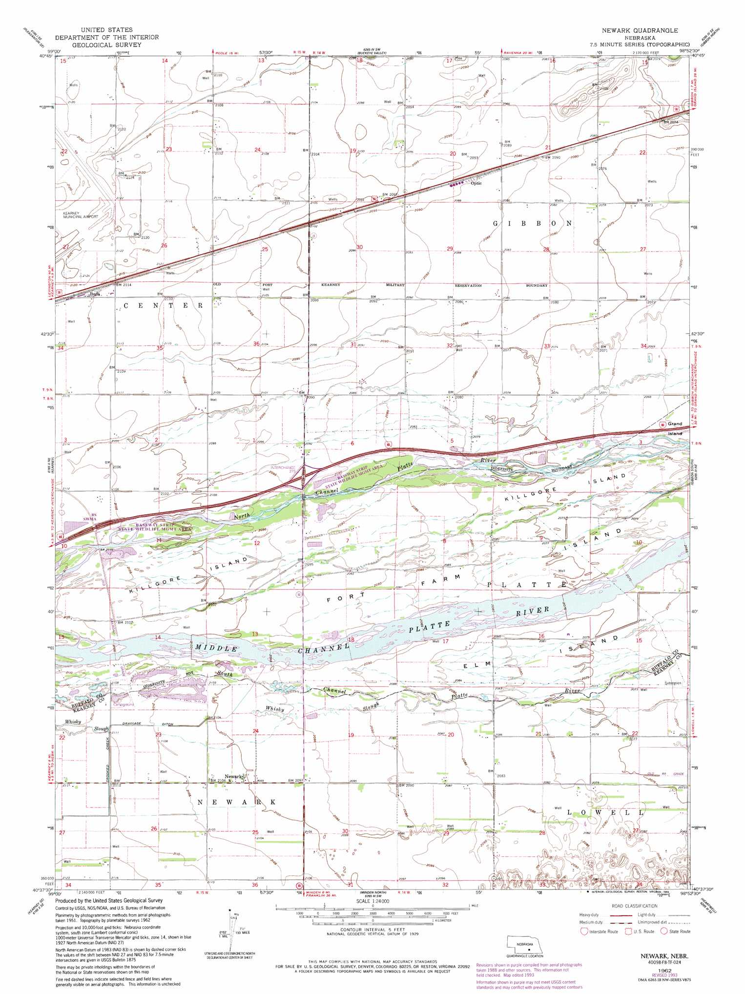
Newark Topo Map Nebraska
To zoom in, hover over the map of Newark
USGS Topo Quad 40098f8 - 1:24,000 scale
| Topo Map Name: | Newark |
| USGS Topo Quad ID: | 40098f8 |
| Print Size: | ca. 21 1/4" wide x 27" high |
| Southeast Coordinates: | 40.625° N latitude / 98.875° W longitude |
| Map Center Coordinates: | 40.6875° N latitude / 98.9375° W longitude |
| U.S. State: | NE |
| Filename: | O40098f8.jpg |
| Download Map JPG Image: | Newark topo map 1:24,000 scale |
| Map Type: | Topographic |
| Topo Series: | 7.5´ |
| Map Scale: | 1:24,000 |
| Source of Map Images: | United States Geological Survey (USGS) |
| Alternate Map Versions: |
Newark NE 1962, updated 1963 Download PDF Buy paper map Newark NE 1962, updated 1977 Download PDF Buy paper map Newark NE 1962, updated 1993 Download PDF Buy paper map Newark NE 2011 Download PDF Buy paper map Newark NE 2014 Download PDF Buy paper map |
1:24,000 Topo Quads surrounding Newark
Pleasanton Nw |
Pleasanton |
Poole |
Poole Ne |
Cameron |
Riverdale |
Pleasanton Se |
Buckeye Valley |
Gibbon North |
Shelton |
Alfalfa Center |
Kearney |
Newark |
Gibbon South |
Denman |
Kearney Sw |
Kearney Se |
Minden North |
Heartwell |
Kenesaw |
Axtell West |
Axtell East |
Minden South |
Norman |
Holstein |
> Back to 40098e1 at 1:100,000 scale
> Back to 40098a1 at 1:250,000 scale
> Back to U.S. Topo Maps home
Newark topo map: Gazetteer
Newark: Canals
Crooked Creek Drainage Ditch elevation 642m 2106′Newark: Crossings
Interchange 279 elevation 640m 2099′Newark: Islands
Fort Farm Island elevation 631m 2070′Killgore Island elevation 638m 2093′
Newark: Parks
Bassway Strip State Wildlife Management Area elevation 638m 2093′Burlington and Missouri River Railroad Historical Marker elevation 639m 2096′
Rowe Sanctuary elevation 632m 2073′
Newark: Populated Places
Buda elevation 645m 2116′Newark elevation 640m 2099′
Newark: Post Offices
Buda Post Office (historical) elevation 645m 2116′Newark Post Office (historical) elevation 640m 2099′
Newark: Streams
Whisky Slough elevation 642m 2106′Newark digital topo map on disk
Buy this Newark topo map showing relief, roads, GPS coordinates and other geographical features, as a high-resolution digital map file on DVD: