Grand Island Topo Map Nebraska
To zoom in, hover over the map of Grand Island
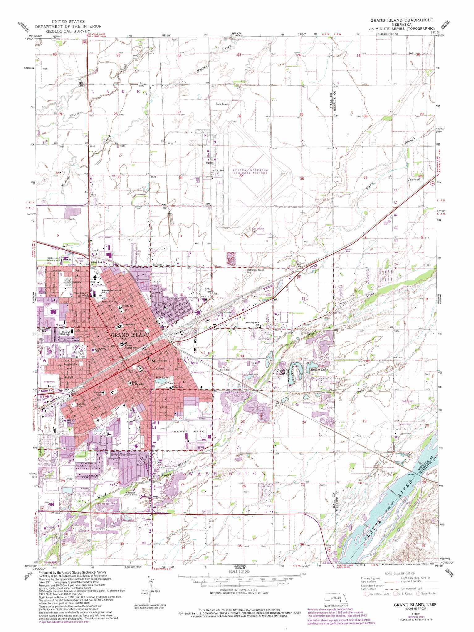
USGS Topo Quad 40098h3 - 1:24,000 scale
| Topo Map Name: | Grand Island |
| USGS Topo Quad ID: | 40098h3 |
| Print Size: | ca. 21 1/4" wide x 27" high |
| Southeast Coordinates: | 40.875° N latitude / 98.25° W longitude |
| Map Center Coordinates: | 40.9375° N latitude / 98.3125° W longitude |
| U.S. State: | NE |
| Filename: | O40098h3.jpg |
| Download Map JPG Image: | Grand Island topo map 1:24,000 scale |
| Map Type: | Topographic |
| Topo Series: | 7.5´ |
| Map Scale: | 1:24,000 |
| Source of Map Images: | United States Geological Survey (USGS) |
| Alternate Map Versions: |
Grand Island NE 1962, updated 1964 Download PDF Buy paper map Grand Island NE 1962, updated 1977 Download PDF Buy paper map Grand Island NE 1962, updated 1984 Download PDF Buy paper map Grand Island NE 1962, updated 1993 Download PDF Buy paper map Grand Island NE 2011 Download PDF Buy paper map Grand Island NE 2014 Download PDF Buy paper map |
1:24,000 Topo Quads surrounding Grand Island
Nysted |
Saint Paul |
Palmer |
Archer |
Hord |
Dannebrog |
Saint Paul Sw |
Saint Lebory |
Chapman |
Central City West |
Shelton Ne |
Abbott |
Grand Island |
Phillips |
Murphy |
Wood River |
Alda |
Doniphan |
Giltner |
Aurora West |
Prosser |
Hastings Nw |
Trumbull |
Harvard Nw |
Harvard Ne |
> Back to 40098e1 at 1:100,000 scale
> Back to 40098a1 at 1:250,000 scale
> Back to U.S. Topo Maps home
Grand Island topo map: Gazetteer
Grand Island: Airports
Central Nebraska Regional Airport elevation 561m 1840′Grand Island: Lakes
Crystal Lake elevation 556m 1824′Eagles Lake elevation 556m 1824′
Lake Davis elevation 557m 1827′
Pier Lake elevation 561m 1840′
Grand Island: Parks
Abbott Park elevation 568m 1863′Ashley Park elevation 567m 1860′
Augustine Park elevation 570m 1870′
Bob Sorenson Softball Complex elevation 567m 1860′
Broadwell Park elevation 570m 1870′
Buechler Park elevation 571m 1873′
Capital Heights Park elevation 567m 1860′
Eagle Scout Park elevation 566m 1856′
Fonner Park elevation 562m 1843′
George Clayton Hall County Park elevation 569m 1866′
Grand Island Heritage Zoo elevation 566m 1856′
Island Oasis Water Park elevation 563m 1847′
LaGrande Isle Historical Marker elevation 566m 1856′
Lincoln Memorial Highway Historical Marker elevation 568m 1863′
Lions Park elevation 567m 1860′
Memorial Park elevation 570m 1870′
Morman Trail Historical Marker elevation 568m 1863′
Northside Fun Park elevation 567m 1860′
O K Store Historical Marker elevation 562m 1843′
Pier Park elevation 563m 1847′
Pioneer Park elevation 568m 1863′
Pioneer Park Historical Marker elevation 568m 1863′
Platt-Duetsche Softball Fields elevation 565m 1853′
Ray Aquatic Park elevation 567m 1860′
Ryder Park elevation 571m 1873′
Schuff Park elevation 563m 1847′
Sothman Park elevation 567m 1860′
Sprague Park elevation 565m 1853′
Stolley State Park elevation 566m 1856′
Vanosdall Softball Fields elevation 565m 1853′
Veterans Park elevation 567m 1860′
Grand Island: Populated Places
Grand Island elevation 567m 1860′Kingwood Estates elevation 563m 1847′
Kuesters Lake elevation 556m 1824′
Parkview elevation 565m 1853′
Pioneer Estates elevation 566m 1856′
Grand Island: Post Offices
Grand Island Post Office elevation 567m 1860′Grand Island: Reservoirs
L E Ray Lake elevation 567m 1860′Grand Island: Trails
Grand Island - State Street Trail elevation 568m 1863′Grand Island digital topo map on disk
Buy this Grand Island topo map showing relief, roads, GPS coordinates and other geographical features, as a high-resolution digital map file on DVD: