Kearney Topo Map Nebraska
To zoom in, hover over the map of Kearney
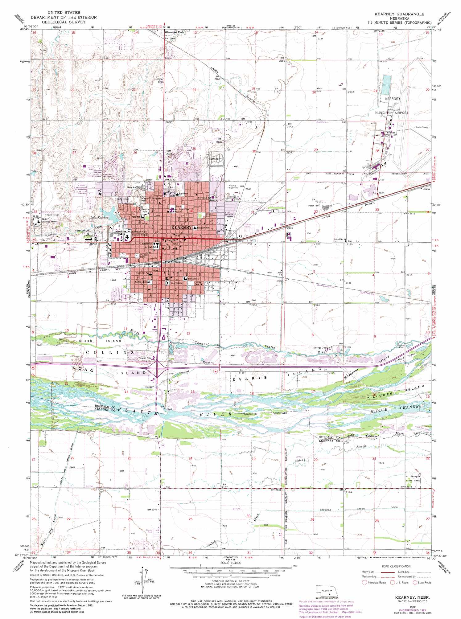
USGS Topo Quad 40099f1 - 1:24,000 scale
| Topo Map Name: | Kearney |
| USGS Topo Quad ID: | 40099f1 |
| Print Size: | ca. 21 1/4" wide x 27" high |
| Southeast Coordinates: | 40.625° N latitude / 99° W longitude |
| Map Center Coordinates: | 40.6875° N latitude / 99.0625° W longitude |
| U.S. State: | NE |
| Filename: | O40099f1.jpg |
| Download Map JPG Image: | Kearney topo map 1:24,000 scale |
| Map Type: | Topographic |
| Topo Series: | 7.5´ |
| Map Scale: | 1:24,000 |
| Source of Map Images: | United States Geological Survey (USGS) |
| Alternate Map Versions: |
Kearney NE 1962, updated 1964 Download PDF Buy paper map Kearney NE 1962, updated 1977 Download PDF Buy paper map Kearney NE 1962, updated 1984 Download PDF Buy paper map Kearney NE 1962, updated 1984 Download PDF Buy paper map Kearney NE 2011 Download PDF Buy paper map Kearney NE 2014 Download PDF Buy paper map |
1:24,000 Topo Quads surrounding Kearney
Miller Ne |
Pleasanton Nw |
Pleasanton |
Poole |
Poole Ne |
Amherst |
Riverdale |
Pleasanton Se |
Buckeye Valley |
Gibbon North |
Elm Creek East |
Alfalfa Center |
Kearney |
Newark |
Gibbon South |
Elm Creek Se |
Kearney Sw |
Kearney Se |
Minden North |
Heartwell |
Holdrege East |
Axtell West |
Axtell East |
Minden South |
Norman |
> Back to 40099e1 at 1:100,000 scale
> Back to 40098a1 at 1:250,000 scale
> Back to U.S. Topo Maps home
Kearney topo map: Gazetteer
Kearney: Airports
Good Samaritan Heliport elevation 659m 2162′Kearney Municipal Airport elevation 648m 2125′
Kearney: Canals
Crooked Creek Ditch elevation 643m 2109′North Dry Creek Ditch elevation 656m 2152′
Walker Channel elevation 653m 2142′
Kearney: Crossings
Interchange 272 elevation 653m 2142′Kearney: Dams
Kearney Dam elevation 667m 2188′Staubitz and Holmes Dam elevation 660m 2165′
Kearney: Islands
Black Island elevation 654m 2145′Buffalo Island elevation 644m 2112′
Evarts Island elevation 650m 2132′
Governor Island elevation 646m 2119′
Kearney: Parks
Apollo Park elevation 668m 2191′Centennial Park elevation 656m 2152′
Collins Park elevation 654m 2145′
Dobytown Historical Marker elevation 650m 2132′
Dryden Park elevation 654m 2145′
Fort Kearney Historical Marker elevation 646m 2119′
Fort Kearney State Historical Park elevation 645m 2116′
Foster Field elevation 666m 2185′
Great Platte River Road Historical Marker elevation 654m 2145′
Harmon Park elevation 665m 2181′
Harvey Park elevation 657m 2155′
Historic Kearney Historical Marker elevation 656m 2152′
Jaycees Park elevation 651m 2135′
Kearney Auto Raceway Park elevation 650m 2132′
Memorial Diamond Park elevation 682m 2237′
Nebraska Wind Sculpture elevation 657m 2155′
Pioneer Park elevation 658m 2158′
Southeast Park elevation 651m 2135′
Ted Baldwin Park elevation 677m 2221′
The Great Plains Historical Marker elevation 657m 2155′
University of Nebraska at Kearney Historical Marker elevation 662m 2171′
Vietnam Memorial elevation 668m 2191′
West Lincolnway Park elevation 665m 2181′
Yanney-Peterson Memorial Carillon Bell Tower elevation 663m 2175′
Kearney: Populated Places
Cornhusker Trailer Court elevation 656m 2152′Countryside Mobile Park elevation 656m 2152′
East Lawn Mobile Home Estates elevation 652m 2139′
Glenwood Mobile Home Park elevation 659m 2162′
Glenwood Park elevation 659m 2162′
Kearney elevation 656m 2152′
Kearney City (historical) elevation 649m 2129′
Prairie View Estates elevation 656m 2152′
Riverside Mobile Home Court elevation 664m 2178′
R-Villa Courts elevation 667m 2188′
Valley View Trailer Court elevation 652m 2139′
Kearney: Post Offices
Glenwood Post Office (historical) elevation 660m 2165′Kearney City Post Office (historical) elevation 649m 2129′
Kearney Post Office elevation 655m 2148′
Kearney: Reservoirs
Kea Lake elevation 653m 2142′Kearney Reservoir elevation 667m 2188′
Lake Kearney elevation 674m 2211′
Staubitz and Holmes Reservoir elevation 660m 2165′
Kearney: Streams
Crooked Creek elevation 650m 2132′North Dry Creek elevation 658m 2158′
Kearney: Trails
Fort Kearney Trail elevation 644m 2112′Kearney digital topo map on disk
Buy this Kearney topo map showing relief, roads, GPS coordinates and other geographical features, as a high-resolution digital map file on DVD: