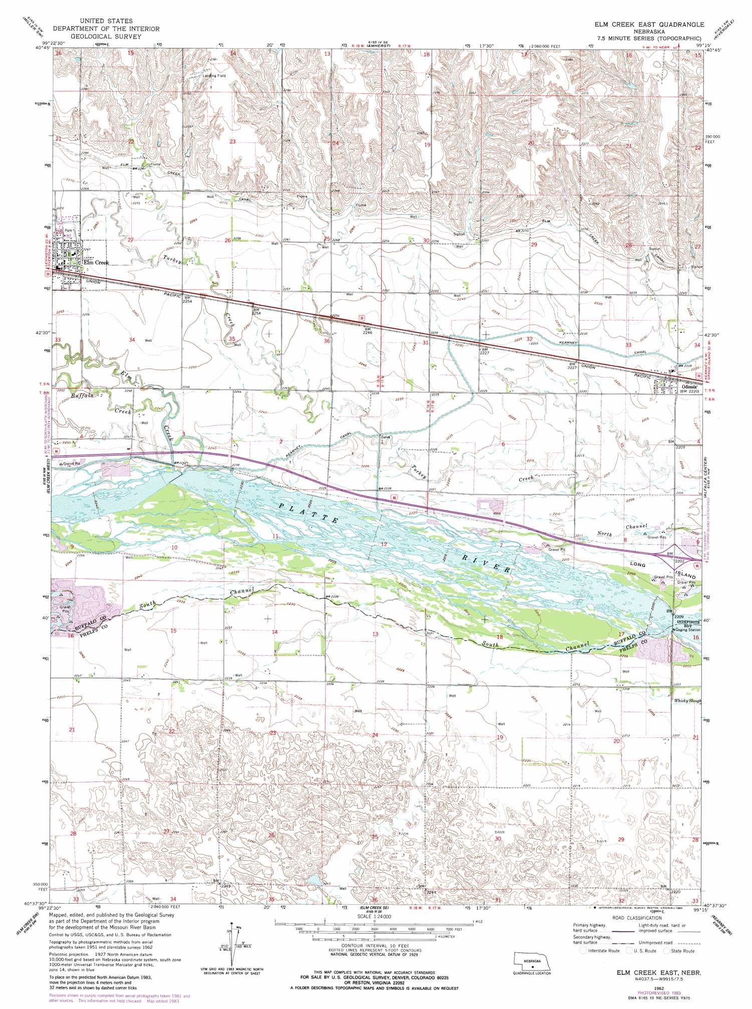
Elm Creek East Topo Map Nebraska
To zoom in, hover over the map of Elm Creek East
USGS Topo Quad 40099f3 - 1:24,000 scale
| Topo Map Name: | Elm Creek East |
| USGS Topo Quad ID: | 40099f3 |
| Print Size: | ca. 21 1/4" wide x 27" high |
| Southeast Coordinates: | 40.625° N latitude / 99.25° W longitude |
| Map Center Coordinates: | 40.6875° N latitude / 99.3125° W longitude |
| U.S. State: | NE |
| Filename: | O40099f3.jpg |
| Download Map JPG Image: | Elm Creek East topo map 1:24,000 scale |
| Map Type: | Topographic |
| Topo Series: | 7.5´ |
| Map Scale: | 1:24,000 |
| Source of Map Images: | United States Geological Survey (USGS) |
| Alternate Map Versions: |
Elm Creek East NE 1962, updated 1964 Download PDF Buy paper map Elm Creek East NE 1962, updated 1984 Download PDF Buy paper map Elm Creek East NE 2011 Download PDF Buy paper map Elm Creek East NE 2014 Download PDF Buy paper map |
1:24,000 Topo Quads surrounding Elm Creek East
Sumner |
Miller |
Miller Ne |
Pleasanton Nw |
Pleasanton |
Lexington Se |
Miller Sw |
Amherst |
Riverdale |
Pleasanton Se |
Overton |
Elm Creek West |
Elm Creek East |
Alfalfa Center |
Kearney |
Bertrand Se |
Elm Creek Sw |
Elm Creek Se |
Kearney Sw |
Kearney Se |
Loomis |
Holdrege West |
Holdrege East |
Axtell West |
Axtell East |
> Back to 40099e1 at 1:100,000 scale
> Back to 40098a1 at 1:250,000 scale
> Back to U.S. Topo Maps home
Elm Creek East topo map: Gazetteer
Elm Creek East: Crossings
Interchange 263 elevation 671m 2201′Elm Creek East: Dams
Kearney Diversion Dam elevation 683m 2240′Elm Creek East: Parks
Blue Hole State Wildlife Management Area elevation 683m 2240′Elm Creek Historical Marker elevation 691m 2267′
Sandy Channel State Recreation Area elevation 684m 2244′
Union Pacific State Recreation Area elevation 670m 2198′
Elm Creek East: Populated Places
Elm Creek elevation 691m 2267′Odessa elevation 677m 2221′
Elm Creek East: Post Offices
Elm Creek Post Office elevation 691m 2267′Odessa Post Office elevation 677m 2221′
Elm Creek East: Reservoirs
Blue Hole East Lake elevation 682m 2237′Kearney Diversion Dam Reservoir elevation 683m 2240′
Elm Creek East: Streams
Buffalo Creek elevation 683m 2240′Elm Creek elevation 682m 2237′
South Channel Platte River elevation 671m 2201′
Elm Creek East digital topo map on disk
Buy this Elm Creek East topo map showing relief, roads, GPS coordinates and other geographical features, as a high-resolution digital map file on DVD: