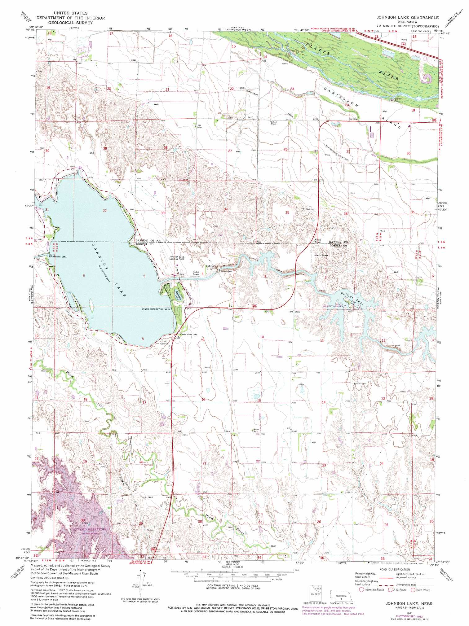
Johnson Lake Topo Map Nebraska
To zoom in, hover over the map of Johnson Lake
USGS Topo Quad 40099f7 - 1:24,000 scale
| Topo Map Name: | Johnson Lake |
| USGS Topo Quad ID: | 40099f7 |
| Print Size: | ca. 21 1/4" wide x 27" high |
| Southeast Coordinates: | 40.625° N latitude / 99.75° W longitude |
| Map Center Coordinates: | 40.6875° N latitude / 99.8125° W longitude |
| U.S. State: | NE |
| Filename: | O40099f7.jpg |
| Download Map JPG Image: | Johnson Lake topo map 1:24,000 scale |
| Map Type: | Topographic |
| Topo Series: | 7.5´ |
| Map Scale: | 1:24,000 |
| Source of Map Images: | United States Geological Survey (USGS) |
| Alternate Map Versions: |
Johnson Lake NE 1971, updated 1973 Download PDF Buy paper map Johnson Lake NE 1971, updated 1984 Download PDF Buy paper map Johnson Lake NE 2011 Download PDF Buy paper map Johnson Lake NE 2014 Download PDF Buy paper map |
1:24,000 Topo Quads surrounding Johnson Lake
Willow Island |
Cozad Nw |
Buffalo |
Lexington Nw |
Sumner |
Gothenburg Se |
Cozad |
Lexington West |
Lexington East |
Lexington Se |
Eustis |
Elwood Nw |
Johnson Lake |
Bertrand Nw |
Overton |
Eustis Se |
Elwood Sw |
Elwood |
Bertrand |
Bertrand Se |
Cambridge Ne |
Arapahoe Nw |
Arapahoe Ne |
Oxford Nw |
Loomis |
> Back to 40099e1 at 1:100,000 scale
> Back to 40098a1 at 1:250,000 scale
> Back to U.S. Topo Maps home
Johnson Lake topo map: Gazetteer
Johnson Lake: Airports
Johnson Lake Airport elevation 799m 2621′Johnson Lake: Bays
Bass Bay elevation 796m 2611′Dry Bay elevation 796m 2611′
Mallard Cove elevation 796m 2611′
North Cove elevation 796m 2611′
Northeast Bay elevation 796m 2611′
Perch Bay elevation 796m 2611′
South Bay elevation 796m 2611′
Johnson Lake: Beaches
East Shore elevation 799m 2621′Mallard Beach elevation 796m 2611′
North Shore elevation 796m 2611′
Johnson Lake: Capes
Bullhead Point elevation 799m 2621′Kilby Point elevation 800m 2624′
North Point elevation 799m 2621′
Johnson Lake: Dams
Earth Dam-Canal Mile 645 Dam elevation 799m 2621′Earth Dam-Canal Mile 671 Dam elevation 779m 2555′
Earth Dam-Canal Mile 681 Dam elevation 784m 2572′
Earth Dam-Canal Mile 689 Dam elevation 764m 2506′
Elwood Dam elevation 795m 2608′
Knoeizer Dam elevation 765m 2509′
Lauby Dam elevation 764m 2506′
Johnson Lake: Lakes
Bossung Lake elevation 796m 2611′Johnson Lake: Parks
Elwood Reservoir Recreation Area elevation 795m 2608′George E Johnson Historical Marker elevation 800m 2624′
Johnson Lake State Recreation Area elevation 796m 2611′
Phillips Lake State Recreation Area elevation 763m 2503′
Johnson Lake: Reservoirs
Elwood Reservoir elevation 795m 2608′Johnson Lake elevation 789m 2588′
Johnson Reservoir elevation 799m 2621′
Knoeizer Reservoir elevation 765m 2509′
Lauby Reservoir elevation 764m 2506′
Philips Lake elevation 763m 2503′
Johnson Lake digital topo map on disk
Buy this Johnson Lake topo map showing relief, roads, GPS coordinates and other geographical features, as a high-resolution digital map file on DVD: