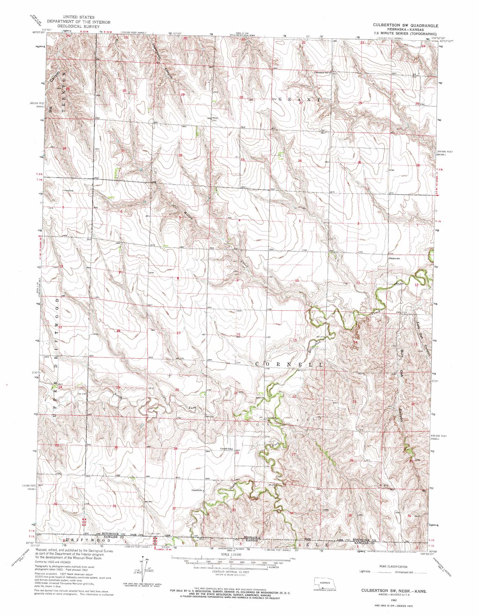
Culbertson Sw Topo Map Nebraska
To zoom in, hover over the map of Culbertson Sw
USGS Topo Quad 40100a8 - 1:24,000 scale
| Topo Map Name: | Culbertson Sw |
| USGS Topo Quad ID: | 40100a8 |
| Print Size: | ca. 21 1/4" wide x 27" high |
| Southeast Coordinates: | 40° N latitude / 100.875° W longitude |
| Map Center Coordinates: | 40.0625° N latitude / 100.9375° W longitude |
| U.S. States: | NE, KS |
| Filename: | O40100a8.jpg |
| Download Map JPG Image: | Culbertson Sw topo map 1:24,000 scale |
| Map Type: | Topographic |
| Topo Series: | 7.5´ |
| Map Scale: | 1:24,000 |
| Source of Map Images: | United States Geological Survey (USGS) |
| Alternate Map Versions: |
Culbertson SW NE 1962, updated 1964 Download PDF Buy paper map Culbertson SW NE 2011 Download PDF Buy paper map Culbertson SW NE 2014 Download PDF Buy paper map |
1:24,000 Topo Quads surrounding Culbertson Sw
Palisade Sw |
Palisade |
Beverly |
Burger Canyon Se |
Red Willow Dam |
Stratton |
Trenton |
Culbertson Nw |
Culbertson |
Mccook West |
Trenton Sw |
Trenton Se |
Culbertson Sw |
Culbertson Se |
Mccook Sw |
Atwood Nw |
Atwood Ne |
Herndon Nw |
Herndon |
Traer |
Beardsley |
Atwood |
Ludell |
Midway |
Oberlin Sw |
> Back to 40100a1 at 1:100,000 scale
> Back to 40100a1 at 1:250,000 scale
> Back to U.S. Topo Maps home
Culbertson Sw topo map: Gazetteer
Culbertson Sw: Populated Places
Cornell (historical) elevation 864m 2834′Culbertson Sw: Post Offices
Cornell Post Office (historical) elevation 864m 2834′Culbertson Sw: Streams
North Fork Driftwood Creek elevation 829m 2719′North Fork Driftwood Creek elevation 829m 2719′
South Fork Driftwood Creek elevation 833m 2732′
South Fork Driftwood Creek elevation 829m 2719′
Willow Creek elevation 819m 2687′
Culbertson Sw: Valleys
Burr Oak Canyon elevation 821m 2693′East Oak Canyon elevation 823m 2700′
Culbertson Sw digital topo map on disk
Buy this Culbertson Sw topo map showing relief, roads, GPS coordinates and other geographical features, as a high-resolution digital map file on DVD: