Weldona Topo Map Colorado
To zoom in, hover over the map of Weldona
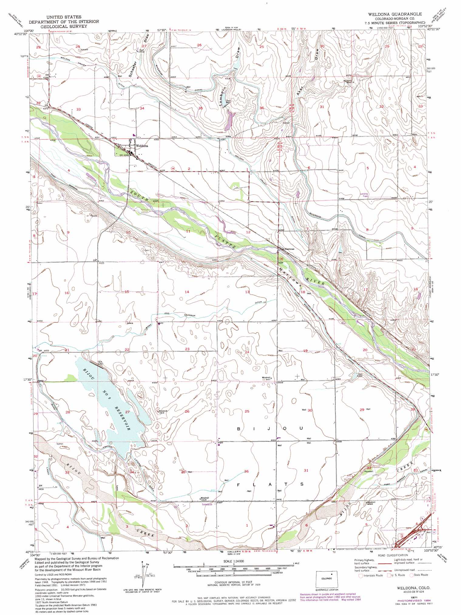
USGS Topo Quad 40103c8 - 1:24,000 scale
| Topo Map Name: | Weldona |
| USGS Topo Quad ID: | 40103c8 |
| Print Size: | ca. 21 1/4" wide x 27" high |
| Southeast Coordinates: | 40.25° N latitude / 103.875° W longitude |
| Map Center Coordinates: | 40.3125° N latitude / 103.9375° W longitude |
| U.S. State: | CO |
| Filename: | o40103c8.jpg |
| Download Map JPG Image: | Weldona topo map 1:24,000 scale |
| Map Type: | Topographic |
| Topo Series: | 7.5´ |
| Map Scale: | 1:24,000 |
| Source of Map Images: | United States Geological Survey (USGS) |
| Alternate Map Versions: |
Weldona CO 1951, updated 1952 Download PDF Buy paper map Weldona CO 1951, updated 1952 Download PDF Buy paper map Weldona CO 1951, updated 1969 Download PDF Buy paper map Weldona CO 1951, updated 1972 Download PDF Buy paper map Weldona CO 1951, updated 1972 Download PDF Buy paper map Weldona CO 1971, updated 1984 Download PDF Buy paper map Weldona CO 2010 Download PDF Buy paper map Weldona CO 2013 Download PDF Buy paper map Weldona CO 2016 Download PDF Buy paper map |
1:24,000 Topo Quads surrounding Weldona
Dutch Girl Lake |
Keota Se |
Buckingham |
Raymer |
Stoneham |
Greasewood Lake |
Sunken Lake |
Judson Hills |
Peace Valley School |
Dead Horse Springs |
Masters |
Orchard |
Weldona |
Fort Morgan |
Brush West |
Omar |
Wiggins |
Vallery |
Lamb |
Round Top |
Wiggins Sw |
Hoyt |
Adena |
Vallery Se |
Huey Ranch |
> Back to 40103a1 at 1:100,000 scale
> Back to 40102a1 at 1:250,000 scale
> Back to U.S. Topo Maps home
Weldona topo map: Gazetteer
Weldona: Canals
Layton Lateral Ditch elevation 1357m 4452′Work and Dragman Ditch elevation 1353m 4438′
Weldona: Dams
Bijou Number 2 Dam elevation 1357m 4452′Christensen Number 1 Dam elevation 1348m 4422′
Lamborn Number 1 Dam elevation 1360m 4461′
Lamborn Number 2 Dam elevation 1347m 4419′
Weldona: Flats
Bijou Flats elevation 1347m 4419′Weldona: Populated Places
Weldona elevation 1326m 4350′Weldona: Reservoirs
Bijou Number 2 Reservoir elevation 1357m 4452′Christensen Reservoir Number 1 elevation 1348m 4422′
Lamborn Reservoir Number 1 elevation 1360m 4461′
Lamborn Reservoir Number 2 elevation 1347m 4419′
Weldona: Valleys
Aker Draw elevation 1336m 4383′Lamborn Draw elevation 1337m 4386′
Narrows elevation 1312m 4304′
Schaefer Draw elevation 1338m 4389′
Weldona digital topo map on disk
Buy this Weldona topo map showing relief, roads, GPS coordinates and other geographical features, as a high-resolution digital map file on DVD: