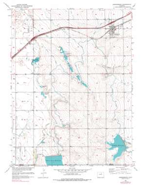
Keenesburg Topo Map Colorado
To zoom in, hover over the map of Keenesburg
USGS Topo Quad 40104a5 - 1:24,000 scale
| Topo Map Name: | Keenesburg |
| USGS Topo Quad ID: | 40104a5 |
| Print Size: | ca. 21 1/4" wide x 27" high |
| Southeast Coordinates: | 40° N latitude / 104.5° W longitude |
| Map Center Coordinates: | 40.0625° N latitude / 104.5625° W longitude |
| U.S. State: | CO |
| Filename: | o40104a5.jpg |
| Download Map JPG Image: | Keenesburg topo map 1:24,000 scale |
| Map Type: | Topographic |
| Topo Series: | 7.5´ |
| Map Scale: | 1:24,000 |
| Source of Map Images: | United States Geological Survey (USGS) |
| Alternate Map Versions: |
Keenesburg CO 1950, updated 1958 Download PDF Buy paper map Keenesburg CO 1950, updated 1972 Download PDF Buy paper map Keenesburg CO 1950, updated 1972 Download PDF Buy paper map Keenesburg CO 1950, updated 1978 Download PDF Buy paper map Keenesburg CO 1951 Download PDF Buy paper map Keenesburg CO 2010 Download PDF Buy paper map Keenesburg CO 2013 Download PDF Buy paper map Keenesburg CO 2016 Download PDF Buy paper map |
1:24,000 Topo Quads surrounding Keenesburg
> Back to 40104a1 at 1:100,000 scale
> Back to 40104a1 at 1:250,000 scale
> Back to U.S. Topo Maps home
Keenesburg topo map: Gazetteer
Keenesburg: Airports
Hayes Airport elevation 1529m 5016′Land Airport elevation 1520m 4986′
Lindys Airpark elevation 1530m 5019′
Keenesburg: Canals
Box Elder Lateral elevation 1535m 5036′Denver-Hudson Canal elevation 1546m 5072′
Highline Lateral elevation 1544m 5065′
Jim Number 1 Lateral elevation 1529m 5016′
Jim Number 2 Lateral elevation 1522m 4993′
Keen Lateral elevation 1529m 5016′
Keenesburg: Dams
Banner Lake Number 1 Dam elevation 1532m 5026′Banner Lake Number 3 Dam elevation 1536m 5039′
Banner Lake Number 5 Dam elevation 1528m 5013′
Deremer Lake Number 10 Dam elevation 1513m 4963′
Harry Denning Irrigation Number 1 Dam elevation 1529m 5016′
Horse Creek Dam elevation 1545m 5068′
Ireland Number 5 Dam elevation 1506m 4940′
Sloan Number 1 Dam elevation 1493m 4898′
Keenesburg: Populated Places
Keenesburg elevation 1510m 4954′Roy elevation 1519m 4983′
Keenesburg: Reservoirs
Banner Lake Number 1 Reservoir elevation 1532m 5026′Banner Lake Number 3 Reservoir elevation 1536m 5039′
Banner Lake Number 5 Reservoir elevation 1528m 5013′
Banner Lakes elevation 1524m 5000′
De Remer Lakes elevation 1511m 4957′
Denning Irrigation Reservoir Number 1 elevation 1529m 5016′
Deremer Lake Number 10 elevation 1513m 4963′
Horse Creek Reservoir elevation 1545m 5068′
Ireland Number 5 Reservoir elevation 1506m 4940′
Ireland Reservoir Number Five elevation 1504m 4934′
Ireland Reservoir Number Four elevation 1513m 4963′
Ireland Reservoir Number One elevation 1513m 4963′
Lott Reservoir elevation 1528m 5013′
Prospect Reservoir elevation 1528m 5013′
Sloan Number 1 Reservoir elevation 1493m 4898′
Keenesburg: Streams
Horse Creek elevation 1519m 4983′Jim Creek elevation 1490m 4888′
Keenesburg digital topo map on disk
Buy this Keenesburg topo map showing relief, roads, GPS coordinates and other geographical features, as a high-resolution digital map file on DVD:


