Bracewell Topo Map Colorado
To zoom in, hover over the map of Bracewell
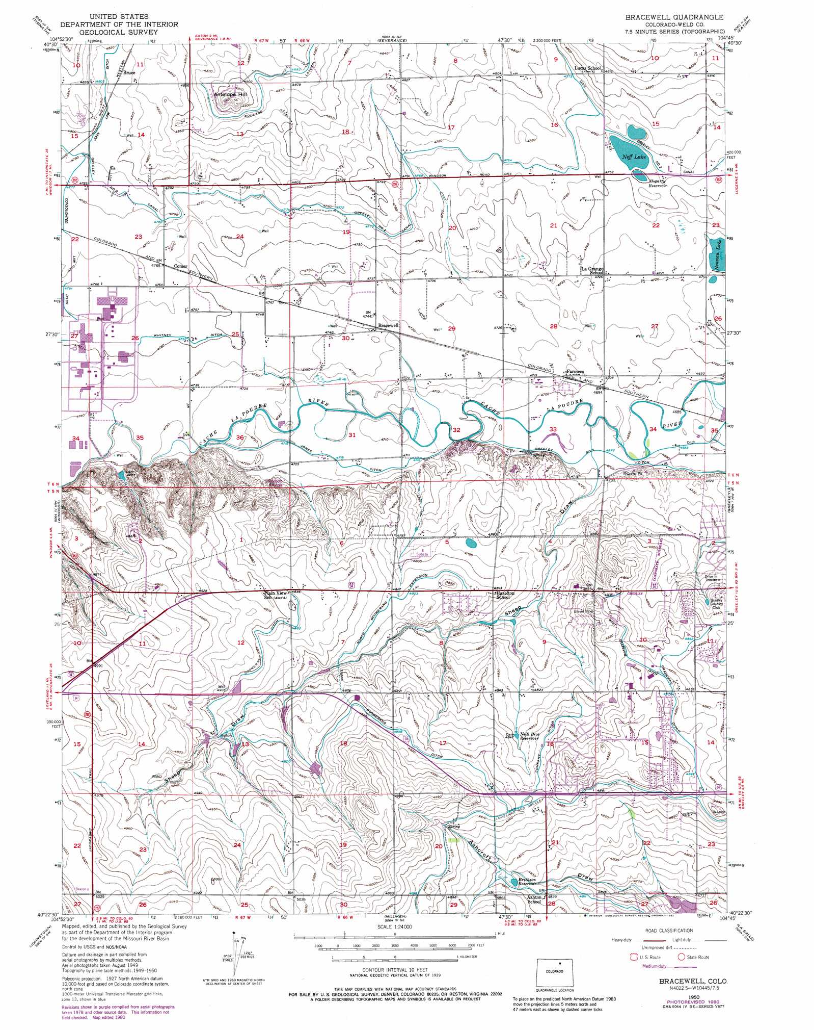
USGS Topo Quad 40104d7 - 1:24,000 scale
| Topo Map Name: | Bracewell |
| USGS Topo Quad ID: | 40104d7 |
| Print Size: | ca. 21 1/4" wide x 27" high |
| Southeast Coordinates: | 40.375° N latitude / 104.75° W longitude |
| Map Center Coordinates: | 40.4375° N latitude / 104.8125° W longitude |
| U.S. State: | CO |
| Filename: | o40104d7.jpg |
| Download Map JPG Image: | Bracewell topo map 1:24,000 scale |
| Map Type: | Topographic |
| Topo Series: | 7.5´ |
| Map Scale: | 1:24,000 |
| Source of Map Images: | United States Geological Survey (USGS) |
| Alternate Map Versions: |
Bracewell CO 1950, updated 1960 Download PDF Buy paper map Bracewell CO 1950, updated 1969 Download PDF Buy paper map Bracewell CO 1950, updated 1970 Download PDF Buy paper map Bracewell CO 1950, updated 1970 Download PDF Buy paper map Bracewell CO 1950, updated 1980 Download PDF Buy paper map Bracewell CO 1950, updated 1982 Download PDF Buy paper map Bracewell CO 1951 Download PDF Buy paper map Bracewell CO 2010 Download PDF Buy paper map Bracewell CO 2013 Download PDF Buy paper map Bracewell CO 2016 Download PDF Buy paper map |
1:24,000 Topo Quads surrounding Bracewell
Wellington |
Cobb Lake |
Nunn |
Antelope Reservoir |
Purcell |
Fort Collins |
Timnath |
Severance |
Eaton |
Galeton |
Loveland |
Windsor |
Bracewell |
Greeley |
Kersey |
Berthoud |
Johnstown |
Milliken |
La Salle |
Valley View School |
Longmont |
Gowanda |
Platteville |
Milton Reservoir |
Klug Ranch |
> Back to 40104a1 at 1:100,000 scale
> Back to 40104a1 at 1:250,000 scale
> Back to U.S. Topo Maps home
Bracewell topo map: Gazetteer
Bracewell: Canals
Boomerang Ditch elevation 1489m 4885′Company Ditch elevation 1488m 4881′
Consolidated Law Ditch elevation 1455m 4773′
Grapevine Ditch elevation 1489m 4885′
Jones Ditch elevation 1440m 4724′
North Boomerang Extension elevation 1471m 4826′
West Grapevine Ditch elevation 1483m 4865′
Bracewell: Lakes
Neff Lake elevation 1449m 4753′Bracewell: Populated Places
Bracewell elevation 1444m 4737′Bruce elevation 1469m 4819′
Comer elevation 1453m 4767′
Farmers elevation 1436m 4711′
Bracewell: Reservoirs
Erickson Reservoir elevation 1476m 4842′Hogarty Reservoir elevation 1448m 4750′
Neill Brothers Reservoir elevation 1476m 4842′
Neuman Lake elevation 1437m 4714′
Bracewell: Summits
Antelope Hill elevation 1507m 4944′Bracewell: Valleys
Sheep Draw elevation 1433m 4701′Bracewell digital topo map on disk
Buy this Bracewell topo map showing relief, roads, GPS coordinates and other geographical features, as a high-resolution digital map file on DVD: