Cobb Lake Topo Map Colorado
To zoom in, hover over the map of Cobb Lake
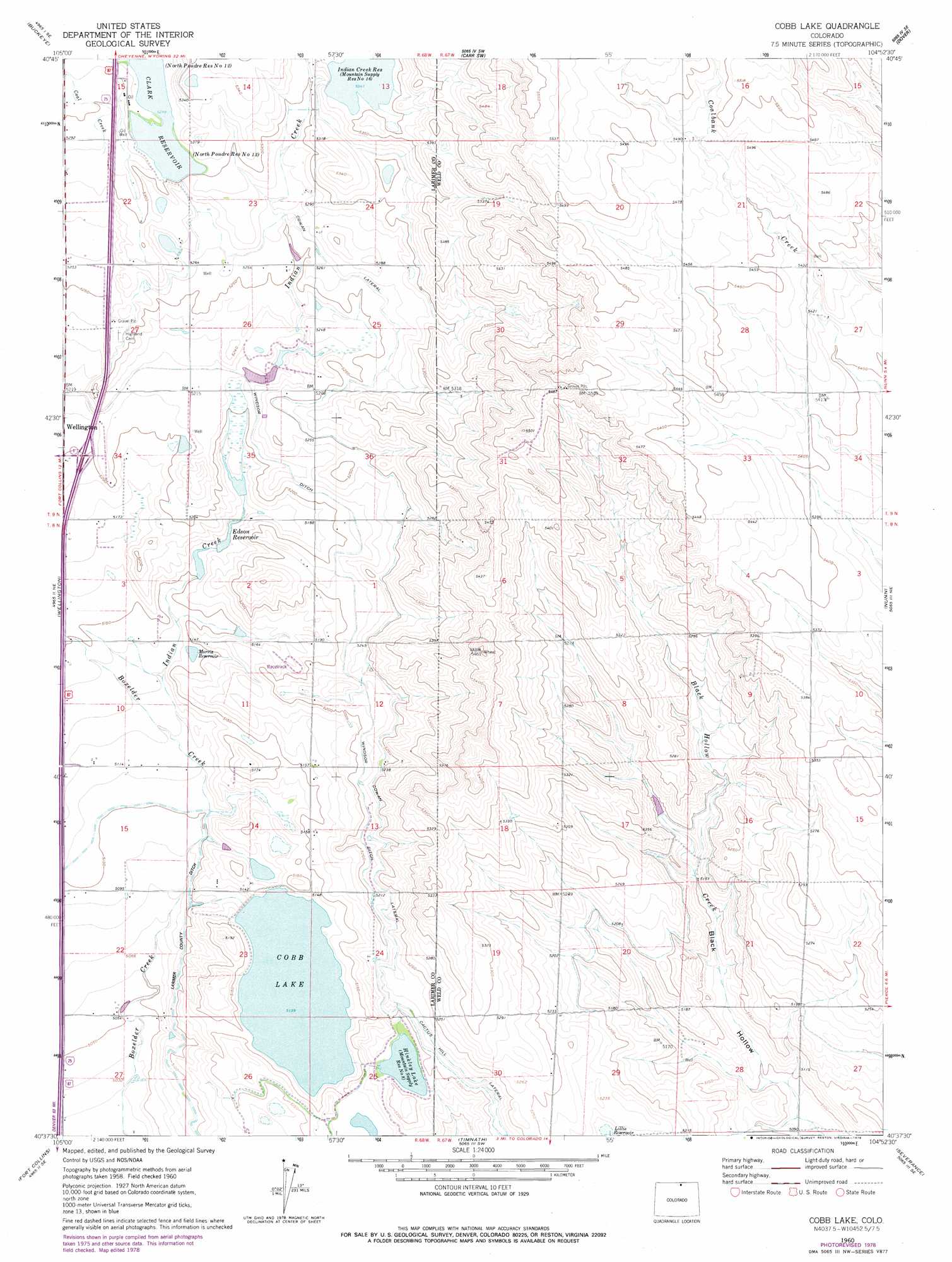
USGS Topo Quad 40104f8 - 1:24,000 scale
| Topo Map Name: | Cobb Lake |
| USGS Topo Quad ID: | 40104f8 |
| Print Size: | ca. 21 1/4" wide x 27" high |
| Southeast Coordinates: | 40.625° N latitude / 104.875° W longitude |
| Map Center Coordinates: | 40.6875° N latitude / 104.9375° W longitude |
| U.S. State: | CO |
| Filename: | o40104f8.jpg |
| Download Map JPG Image: | Cobb Lake topo map 1:24,000 scale |
| Map Type: | Topographic |
| Topo Series: | 7.5´ |
| Map Scale: | 1:24,000 |
| Source of Map Images: | United States Geological Survey (USGS) |
| Alternate Map Versions: |
Cobb Lake CO 1960, updated 1962 Download PDF Buy paper map Cobb Lake CO 1960, updated 1962 Download PDF Buy paper map Cobb Lake CO 1960, updated 1971 Download PDF Buy paper map Cobb Lake CO 1960, updated 1979 Download PDF Buy paper map Cobb Lake CO 2010 Download PDF Buy paper map Cobb Lake CO 2013 Download PDF Buy paper map Cobb Lake CO 2016 Download PDF Buy paper map |
1:24,000 Topo Quads surrounding Cobb Lake
Table Mountain |
Round Butte |
Carr West |
Carr East |
Eastman Creek North |
Livermore |
Buckeye |
Carr Sw |
Dover |
Eastman Creek South |
Laporte |
Wellington |
Cobb Lake |
Nunn |
Antelope Reservoir |
Horsetooth Reservoir |
Fort Collins |
Timnath |
Severance |
Eaton |
Masonville |
Loveland |
Windsor |
Bracewell |
Greeley |
> Back to 40104e1 at 1:100,000 scale
> Back to 40104a1 at 1:250,000 scale
> Back to U.S. Topo Maps home
Cobb Lake topo map: Gazetteer
Cobb Lake: Airports
William T Browder Heliport elevation 1602m 5255′Cobb Lake: Canals
Cowan Lateral elevation 1599m 5246′Timnath Reservoir Outlet elevation 1586m 5203′
Windsor Ditch elevation 1588m 5209′
Cobb Lake: Dams
Clarks Lake Dam elevation 1616m 5301′Cobb Lake Dam elevation 1568m 5144′
Grothe Dam elevation 1586m 5203′
Mountain Supply Number 18 Dam elevation 1580m 5183′
Cobb Lake: Reservoirs
Clark Reservoir elevation 1615m 5298′Clarks Lake elevation 1616m 5301′
Cobb Lake elevation 1568m 5144′
Grothe Reservoir elevation 1586m 5203′
Hinkley Lake elevation 1582m 5190′
Indian Creek Reservoir elevation 1629m 5344′
Lillie Reservoir elevation 1587m 5206′
Morris Reservoir elevation 1569m 5147′
Mountain Supply Reservoir Number 18 elevation 1580m 5183′
Cobb Lake: Streams
Coal Creek elevation 1585m 5200′Indian Creek elevation 1559m 5114′
Cobb Lake digital topo map on disk
Buy this Cobb Lake topo map showing relief, roads, GPS coordinates and other geographical features, as a high-resolution digital map file on DVD: