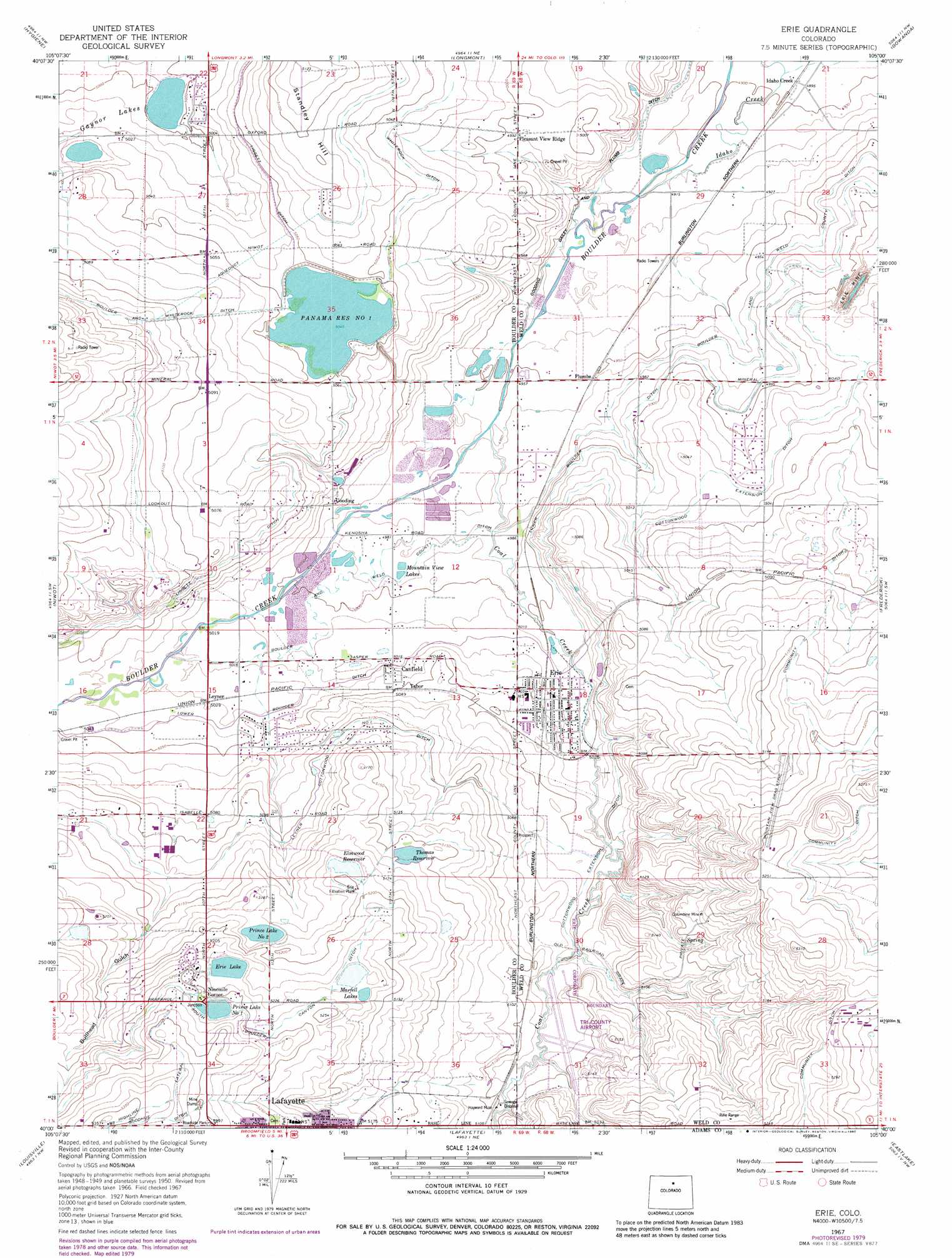
Erie Topo Map Colorado
To zoom in, hover over the map of Erie
USGS Topo Quad 40105a1 - 1:24,000 scale
| Topo Map Name: | Erie |
| USGS Topo Quad ID: | 40105a1 |
| Print Size: | ca. 21 1/4" wide x 27" high |
| Southeast Coordinates: | 40° N latitude / 105° W longitude |
| Map Center Coordinates: | 40.0625° N latitude / 105.0625° W longitude |
| U.S. State: | CO |
| Filename: | o40105a1.jpg |
| Download Map JPG Image: | Erie topo map 1:24,000 scale |
| Map Type: | Topographic |
| Topo Series: | 7.5´ |
| Map Scale: | 1:24,000 |
| Source of Map Images: | United States Geological Survey (USGS) |
| Alternate Map Versions: |
Erie CO 1950, updated 1956 Download PDF Buy paper map Erie CO 1951 Download PDF Buy paper map Erie CO 1967, updated 1968 Download PDF Buy paper map Erie CO 1967, updated 1968 Download PDF Buy paper map Erie CO 1967, updated 1973 Download PDF Buy paper map Erie CO 1967, updated 1973 Download PDF Buy paper map Erie CO 1967, updated 1980 Download PDF Buy paper map Erie CO 2010 Download PDF Buy paper map Erie CO 2013 Download PDF Buy paper map Erie CO 2016 Download PDF Buy paper map |
1:24,000 Topo Quads surrounding Erie
Pinewood Lake |
Carter Lake Reservoir |
Berthoud |
Johnstown |
Milliken |
Lyons |
Hygiene |
Longmont |
Gowanda |
Platteville |
Boulder |
Niwot |
Erie |
Frederick |
Fort Lupton |
Eldorado Springs |
Louisville |
Lafayette |
Eastlake |
Brighton |
Ralston Buttes |
Golden |
Arvada |
Commerce City |
Sable |
> Back to 40105a1 at 1:100,000 scale
> Back to 40104a1 at 1:250,000 scale
> Back to U.S. Topo Maps home
Erie topo map: Gazetteer
Erie: Airports
Daves Stolport elevation 1577m 5173′Leyners Hayfield Airport elevation 1539m 5049′
Parkland Airport elevation 1535m 5036′
Tri-County Airport elevation 1552m 5091′
Tri-County Heliport elevation 1550m 5085′
Erie: Canals
Boulder and Weld County Ditch elevation 1518m 4980′Cottonwood Extension Ditch elevation 1539m 5049′
Godding Dailey and Plumb Ditch elevation 1502m 4927′
Leyner Cottonwood Number 1 Ditch elevation 1556m 5104′
Liggett Ditch elevation 1542m 5059′
Lower Boulder Ditch elevation 1531m 5022′
South Boulder Canyon elevation 1603m 5259′
Whiterock Ditch elevation 1538m 5045′
Erie: Dams
Elmwood Dam elevation 1584m 5196′Erie Dam elevation 1597m 5239′
Gaynor Dam elevation 1531m 5022′
Marfell Lake Number 1 Dam elevation 1593m 5226′
Panama Number 1 Dam elevation 1540m 5052′
Prince Number 1 Dam elevation 1603m 5259′
Prince Number 2 Dam elevation 1575m 5167′
Erie: Lakes
Gaynor Lake elevation 1531m 5022′Erie: Mines
Bailey Gravel Pit elevation 1531m 5022′Boulder Valley Mine elevation 1584m 5196′
Boulder Valley Mine elevation 1540m 5052′
Boulder Valley Mine elevation 1523m 4996′
Brennan Mine elevation 1543m 5062′
Briggs Mine elevation 1538m 5045′
C and M Gravel Pit elevation 1531m 5022′
Chase Mine elevation 1551m 5088′
Clayton Mine elevation 1577m 5173′
Cleveland Mine elevation 1568m 5144′
Columbine Mine elevation 1580m 5183′
Crandell Number One Mine elevation 1590m 5216′
Erie Mine elevation 1540m 5052′
Erie Mine elevation 1528m 5013′
Erie Pit elevation 1531m 5022′
Eureka Number One Mine elevation 1532m 5026′
Excelsior Mine elevation 1591m 5219′
Garfield Mine elevation 1571m 5154′
Garfield Number Two Mine elevation 1542m 5059′
Gladstone Mine elevation 1599m 5246′
Hayward Mine elevation 1553m 5095′
Jackson Mine elevation 1513m 4963′
Lehigh Mine elevation 1541m 5055′
Lister Mine elevation 1571m 5154′
Lloyd Mine elevation 1543m 5062′
Longs Peak Mine elevation 1513m 4963′
MacGregor Mine elevation 1571m 5154′
Marfell Mine elevation 1571m 5154′
Mile Hi Mine elevation 1589m 5213′
Mitchell Mine elevation 1599m 5246′
Mitchell Number Two Mine elevation 1551m 5088′
Monroe Mine elevation 1582m 5190′
New Star Mine elevation 1513m 4963′
Northrup Mine elevation 1513m 4963′
Northwestern Mine elevation 1546m 5072′
Northwestern Mine elevation 1544m 5065′
Pallotts Coal Workings elevation 1542m 5059′
Paramount Mine elevation 1615m 5298′
Park Mine elevation 1556m 5104′
Pinnacle Mine elevation 1571m 5154′
Reliance Mine elevation 1550m 5085′
Simpson Coal Mine elevation 1599m 5246′
Star Mine elevation 1534m 5032′
State Pit elevation 1584m 5196′
Stewart Mine elevation 1539m 5049′
Stuart Mine elevation 1571m 5154′
Tynan Mine elevation 1571m 5154′
Warwick Mine elevation 1571m 5154′
Washington Mine elevation 1571m 5154′
Erie: Populated Places
Canfield elevation 1536m 5039′Erie elevation 1532m 5026′
Gooding elevation 1526m 5006′
Idaho Creek elevation 1494m 4901′
Leyner elevation 1534m 5032′
Ninemile Corner elevation 1605m 5265′
Pleasant View Ridge elevation 1523m 4996′
Plumbs elevation 1511m 4957′
Tabor elevation 1540m 5052′
Erie: Reservoirs
Elmwood Reservoir elevation 1584m 5196′Erie Lake elevation 1597m 5239′
Marfell Lake Number 1 elevation 1593m 5226′
Marfell Lakes elevation 1593m 5226′
Mountain View Lakes elevation 1521m 4990′
Panama Reservoir Number 1 elevation 1540m 5052′
Prince Lake Number 1 elevation 1602m 5255′
Prince Lake Number 2 elevation 1576m 5170′
Prince Reservoir Number 1 elevation 1603m 5259′
Prince Reservoir Number 2 elevation 1575m 5167′
Thomas Reservoir elevation 1572m 5157′
Erie: Streams
Coal Creek elevation 1512m 4960′Erie: Summits
Standley Hill elevation 1562m 5124′Erie: Valleys
Bullhead Gulch elevation 1564m 5131′Erie digital topo map on disk
Buy this Erie topo map showing relief, roads, GPS coordinates and other geographical features, as a high-resolution digital map file on DVD: