Strawberry Lake Topo Map Colorado
To zoom in, hover over the map of Strawberry Lake
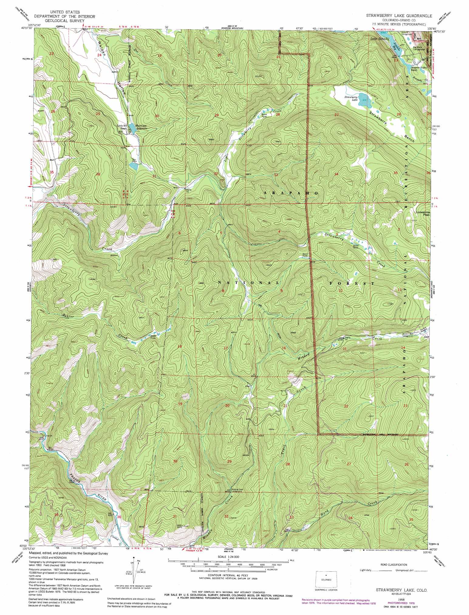
USGS Topo Quad 40105a7 - 1:24,000 scale
| Topo Map Name: | Strawberry Lake |
| USGS Topo Quad ID: | 40105a7 |
| Print Size: | ca. 21 1/4" wide x 27" high |
| Southeast Coordinates: | 40° N latitude / 105.75° W longitude |
| Map Center Coordinates: | 40.0625° N latitude / 105.8125° W longitude |
| U.S. State: | CO |
| Filename: | o40105a7.jpg |
| Download Map JPG Image: | Strawberry Lake topo map 1:24,000 scale |
| Map Type: | Topographic |
| Topo Series: | 7.5´ |
| Map Scale: | 1:24,000 |
| Source of Map Images: | United States Geological Survey (USGS) |
| Alternate Map Versions: |
Strawberry Lake CO 1958, updated 1959 Download PDF Buy paper map Strawberry Lake CO 1958, updated 1962 Download PDF Buy paper map Strawberry Lake CO 1958, updated 1973 Download PDF Buy paper map Strawberry Lake CO 1958, updated 1978 Download PDF Buy paper map Strawberry Lake CO 1958, updated 1992 Download PDF Buy paper map Strawberry Lake CO 1958, updated 1992 Download PDF Buy paper map Strawberry Lake CO 2011 Download PDF Buy paper map Strawberry Lake CO 2013 Download PDF Buy paper map Strawberry Lake CO 2016 Download PDF Buy paper map |
| FStopo: | US Forest Service topo Strawberry Lake is available: Download FStopo PDF Download FStopo TIF |
1:24,000 Topo Quads surrounding Strawberry Lake
Radial Mountain |
Bowen Mountain |
Grand Lake |
Mchenrys Peak |
Longs Peak |
Cabin Creek |
Trail Mountain |
Shadow Mountain |
Isolation Peak |
Allens Park |
Hot Sulpher Springs |
Granby |
Strawberry Lake |
Monarch Lake |
Ward |
Sylvan Reservoir |
Bottle Pass |
Fraser |
East Portal |
Nederland |
Ute Peak |
Byers Peak |
Berthoud Pass |
Empire |
Central City |
> Back to 40105a1 at 1:100,000 scale
> Back to 40104a1 at 1:250,000 scale
> Back to U.S. Topo Maps home
Strawberry Lake topo map: Gazetteer
Strawberry Lake: Bays
Arapaho Bay elevation 2525m 8284′Strawberry Lake: Benches
Strawberry Bench elevation 2802m 9192′Strawberry Lake: Canals
Meadow Creek Ditch elevation 2866m 9402′Strawberry Lake: Dams
Hankison Dam elevation 2587m 8487′Meadow Creek Dam elevation 3024m 9921′
Strawberry Lake: Lakes
Strawberry Lake elevation 2803m 9196′Strawberry Lake: Mines
Beaver Mica Mine elevation 2995m 9826′Strawberry Lake: Reservoirs
Hankison Reservoir elevation 2587m 8487′Meadow Creek Reservoir elevation 3024m 9921′
Strawberry Lake: Streams
Arapaho Creek elevation 2526m 8287′Crooked Creek elevation 2525m 8284′
Doe Creek elevation 2537m 8323′
Irving Hale Creek elevation 2527m 8290′
Little Strawberry Creek elevation 2650m 8694′
Meadow Creek elevation 2619m 8592′
Strawberry Lake: Trails
Caribou Trail elevation 2922m 9586′Strawberry Trail elevation 2801m 9189′
Strawberry Lake digital topo map on disk
Buy this Strawberry Lake topo map showing relief, roads, GPS coordinates and other geographical features, as a high-resolution digital map file on DVD: