Loveland Topo Map Colorado
To zoom in, hover over the map of Loveland
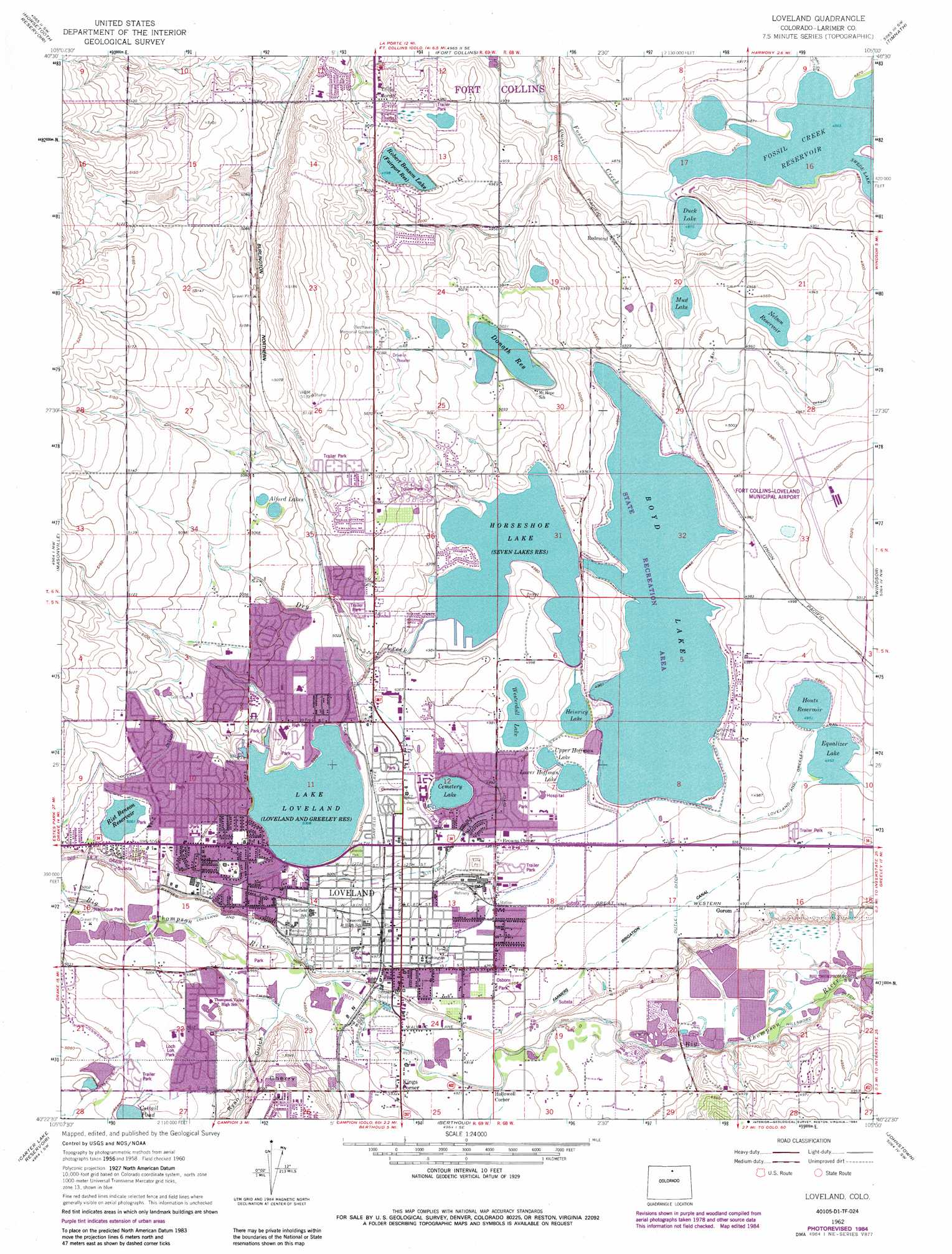
USGS Topo Quad 40105d1 - 1:24,000 scale
| Topo Map Name: | Loveland |
| USGS Topo Quad ID: | 40105d1 |
| Print Size: | ca. 21 1/4" wide x 27" high |
| Southeast Coordinates: | 40.375° N latitude / 105° W longitude |
| Map Center Coordinates: | 40.4375° N latitude / 105.0625° W longitude |
| U.S. State: | CO |
| Filename: | o40105d1.jpg |
| Download Map JPG Image: | Loveland topo map 1:24,000 scale |
| Map Type: | Topographic |
| Topo Series: | 7.5´ |
| Map Scale: | 1:24,000 |
| Source of Map Images: | United States Geological Survey (USGS) |
| Alternate Map Versions: |
Loveland CO 1960, updated 1965 Download PDF Buy paper map Loveland CO 1962, updated 1963 Download PDF Buy paper map Loveland CO 1962, updated 1970 Download PDF Buy paper map Loveland CO 1962, updated 1970 Download PDF Buy paper map Loveland CO 1962, updated 1984 Download PDF Buy paper map Loveland CO 2010 Download PDF Buy paper map Loveland CO 2013 Download PDF Buy paper map Loveland CO 2016 Download PDF Buy paper map |
1:24,000 Topo Quads surrounding Loveland
Poudre Park |
Laporte |
Wellington |
Cobb Lake |
Nunn |
Buckhorn Mountain |
Horsetooth Reservoir |
Fort Collins |
Timnath |
Severance |
Drake |
Masonville |
Loveland |
Windsor |
Bracewell |
Pinewood Lake |
Carter Lake Reservoir |
Berthoud |
Johnstown |
Milliken |
Lyons |
Hygiene |
Longmont |
Gowanda |
Platteville |
> Back to 40105a1 at 1:100,000 scale
> Back to 40104a1 at 1:250,000 scale
> Back to U.S. Topo Maps home
Loveland topo map: Gazetteer
Loveland: Airports
Fort Collins-Loveland Municipal Airport elevation 1523m 4996′Loveland Airport elevation 1528m 5013′
McKee Medical Center Heliport elevation 1517m 4977′
Loveland: Canals
Big Barnes Ditch elevation 1532m 5026′Farmers Ditch elevation 1506m 4940′
Little Barnes Ditch elevation 1524m 5000′
Louden Ditch elevation 1547m 5075′
Loveland: Dams
Boyd Lake Dam elevation 1517m 4977′Cemetery Lake Dam elevation 1525m 5003′
Duck Lake Dam elevation 1488m 4881′
Dyekman Dam elevation 1533m 5029′
Houts Dam elevation 1510m 4954′
Loveland: Lakes
Alford Lakes elevation 1543m 5062′Cattail Pond elevation 1539m 5049′
Cemetery Lake elevation 1524m 5000′
Lower Hoffman Lake elevation 1514m 4967′
Mud Lake elevation 1499m 4917′
Rollers Lake elevation 1540m 5052′
Upper Hoffman Lake elevation 1514m 4967′
Westerdoll Lake elevation 1518m 4980′
Loveland: Mines
Big Thompson Pit elevation 1521m 4990′Boyd Lake Quarry elevation 1521m 4990′
Coulson Excavating Pit elevation 1521m 4990′
Coulson Pit elevation 1521m 4990′
Haag Pit elevation 1521m 4990′
Haags Sand and Gravel Pit elevation 1523m 4996′
Kauffman Pit elevation 1521m 4990′
Loveland Gravel Pit elevation 1524m 5000′
Loveland Sugar Refinery Quarry elevation 1521m 4990′
Say Hawker Pit elevation 1519m 4983′
Swart Pit elevation 1521m 4990′
U.S. Gypsum Quarry elevation 1521m 4990′
Loveland: Parks
Boyd Lake State Park elevation 1521m 4990′Lakeside Park elevation 1532m 5026′
Loch Lon Park elevation 1531m 5022′
Namaqua Park elevation 1525m 5003′
Osborn Park elevation 1510m 4954′
Loveland: Populated Places
Browns Corner elevation 1522m 4993′Kings Corner elevation 1504m 4934′
Loveland elevation 1519m 4983′
Redmond elevation 1501m 4924′
Trilby Corner elevation 1535m 5036′
Loveland: Reservoirs
Boyd Lake elevation 1517m 4977′Duck Lake elevation 1488m 4881′
Dyekman Reservoir elevation 1533m 5029′
Equalizer Lake elevation 1511m 4957′
Heinricy Lake elevation 1515m 4970′
Horseshoe Lake elevation 1518m 4980′
Houts Reservoir elevation 1510m 4954′
Lake Loveland elevation 1528m 5013′
Nelson Reservoir elevation 1505m 4937′
Rist Benson Reservoir elevation 1543m 5062′
Robert Benson Lake elevation 1524m 5000′
Loveland: Streams
Dry Creek elevation 1519m 4983′Loveland: Summits
Cherry Hill elevation 1540m 5052′Loveland: Valleys
Ryan Gulch elevation 1512m 4960′Loveland digital topo map on disk
Buy this Loveland topo map showing relief, roads, GPS coordinates and other geographical features, as a high-resolution digital map file on DVD: