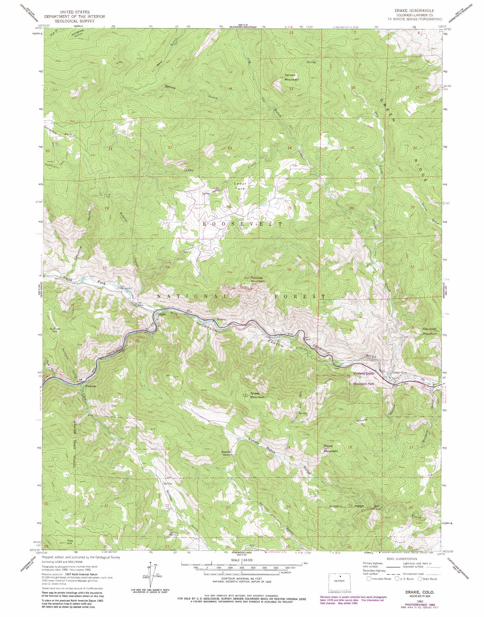
Drake Topo Map Colorado
To zoom in, hover over the map of Drake
USGS Topo Quad 40105d3 - 1:24,000 scale
| Topo Map Name: | Drake |
| USGS Topo Quad ID: | 40105d3 |
| Print Size: | ca. 21 1/4" wide x 27" high |
| Southeast Coordinates: | 40.375° N latitude / 105.25° W longitude |
| Map Center Coordinates: | 40.4375° N latitude / 105.3125° W longitude |
| U.S. State: | CO |
| Filename: | o40105d3.jpg |
| Download Map JPG Image: | Drake topo map 1:24,000 scale |
| Map Type: | Topographic |
| Topo Series: | 7.5´ |
| Map Scale: | 1:24,000 |
| Source of Map Images: | United States Geological Survey (USGS) |
| Alternate Map Versions: |
Drake CO 1962, updated 1964 Download PDF Buy paper map Drake CO 1962, updated 1970 Download PDF Buy paper map Drake CO 1962, updated 1970 Download PDF Buy paper map Drake CO 1962, updated 1977 Download PDF Buy paper map Drake CO 1962, updated 1984 Download PDF Buy paper map Drake CO 2011 Download PDF Buy paper map Drake CO 2013 Download PDF Buy paper map Drake CO 2016 Download PDF Buy paper map |
| FStopo: | US Forest Service topo Drake is available: Download FStopo PDF Download FStopo TIF |
1:24,000 Topo Quads surrounding Drake
Rustic |
Big Narrows |
Poudre Park |
Laporte |
Wellington |
Pingree Park |
Crystal Mountain |
Buckhorn Mountain |
Horsetooth Reservoir |
Fort Collins |
Estes Park |
Glen Haven |
Drake |
Masonville |
Loveland |
Longs Peak |
Panorama Peak |
Pinewood Lake |
Carter Lake Reservoir |
Berthoud |
Allens Park |
Raymond |
Lyons |
Hygiene |
Longmont |
> Back to 40105a1 at 1:100,000 scale
> Back to 40104a1 at 1:250,000 scale
> Back to U.S. Topo Maps home
Drake topo map: Gazetteer
Drake: Dams
Cedar Springs Dam elevation 2082m 6830′Idylwilde Dam elevation 1871m 6138′
Drake: Flats
Cedar Park elevation 2095m 6873′Galuchie Park elevation 2619m 8592′
Sullivan Park elevation 2194m 7198′
Drake: Gaps
Saddle Notch elevation 2192m 7191′Drake: Mines
Hide-a-way Claim elevation 2821m 9255′Hilltop Number Three Claims elevation 2815m 9235′
Hyatt Mine elevation 2483m 8146′
Drake: Parks
Loveland Mountain Park elevation 1776m 5826′Veterans Memorial Park elevation 2204m 7230′
Drake: Populated Places
Cedar Cove elevation 1700m 5577′Drake elevation 1878m 6161′
Midway elevation 1859m 6099′
Waltonia elevation 1983m 6505′
Drake: Reservoirs
Cedar Springs Reservoir elevation 2082m 6830′Idylwilde Reservoir elevation 1871m 6138′
Drake: Ridges
Bald Ridge elevation 2505m 8218′Green Ridge elevation 2153m 7063′
Drake: Streams
Cedar Creek elevation 1699m 5574′Dry Creek elevation 1840m 6036′
North Fork Big Thompson River elevation 1875m 6151′
Drake: Summits
Alexander Mountain elevation 2156m 7073′Palisade Mountain elevation 2507m 8225′
Pole Hill elevation 2647m 8684′
Sheep Mountain elevation 2578m 8458′
Spruce Mountain elevation 2371m 7778′
Stone Mountain elevation 2301m 7549′
Drake: Trails
Jug Trail elevation 2009m 6591′Round Mountain Trail elevation 2215m 7267′
Drake: Valleys
Bobcat Gulch elevation 1901m 6236′Dickson Gulch elevation 1696m 5564′
Galuchie Gulch elevation 1934m 6345′
Grouse Hollow elevation 1707m 5600′
Jug Gulch elevation 1954m 6410′
Quillan Gulch elevation 1977m 6486′
Saddle Notch Gulch elevation 1866m 6122′
Spruce Gulch elevation 2011m 6597′
Sullivan Gulch elevation 1986m 6515′
True Gulch elevation 2007m 6584′
Drake digital topo map on disk
Buy this Drake topo map showing relief, roads, GPS coordinates and other geographical features, as a high-resolution digital map file on DVD: