Estes Park Topo Map Colorado
To zoom in, hover over the map of Estes Park
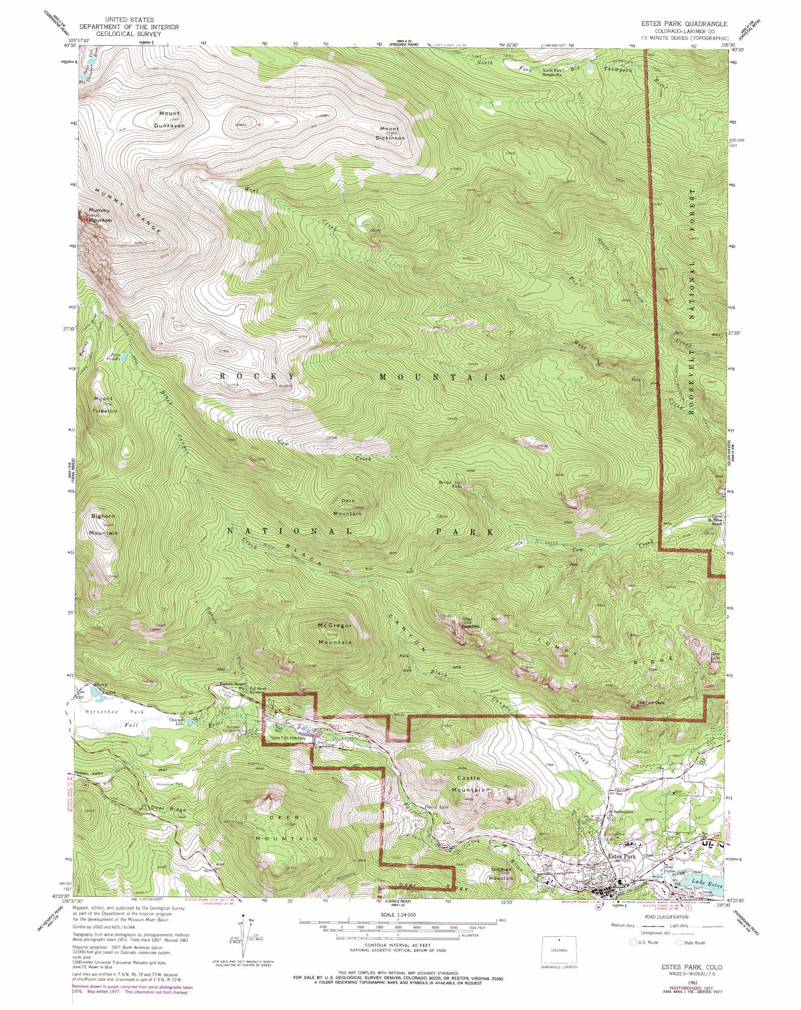
USGS Topo Quad 40105d5 - 1:24,000 scale
| Topo Map Name: | Estes Park |
| USGS Topo Quad ID: | 40105d5 |
| Print Size: | ca. 21 1/4" wide x 27" high |
| Southeast Coordinates: | 40.375° N latitude / 105.5° W longitude |
| Map Center Coordinates: | 40.4375° N latitude / 105.5625° W longitude |
| U.S. State: | CO |
| Filename: | o40105d5.jpg |
| Download Map JPG Image: | Estes Park topo map 1:24,000 scale |
| Map Type: | Topographic |
| Topo Series: | 7.5´ |
| Map Scale: | 1:24,000 |
| Source of Map Images: | United States Geological Survey (USGS) |
| Alternate Map Versions: |
Estes Park CO 1957, updated 1959 Download PDF Buy paper map Estes Park CO 1961, updated 1961 Download PDF Buy paper map Estes Park CO 1961, updated 1965 Download PDF Buy paper map Estes Park CO 1961, updated 1965 Download PDF Buy paper map Estes Park CO 1961, updated 1971 Download PDF Buy paper map Estes Park CO 1961, updated 1978 Download PDF Buy paper map Estes Park CO 1961, updated 1988 Download PDF Buy paper map Estes Park CO 1961, updated 1988 Download PDF Buy paper map Estes Park CO 2011 Download PDF Buy paper map Estes Park CO 2013 Download PDF Buy paper map Estes Park CO 2016 Download PDF Buy paper map |
| FStopo: | US Forest Service topo Estes Park is available: Download FStopo PDF Download FStopo TIF |
1:24,000 Topo Quads surrounding Estes Park
Boston Peak |
Kinikinik |
Rustic |
Big Narrows |
Poudre Park |
Chambers Lake |
Comanche Peak |
Pingree Park |
Crystal Mountain |
Buckhorn Mountain |
Fall River Pass |
Trail Ridge |
Estes Park |
Glen Haven |
Drake |
Grand Lake |
Mchenrys Peak |
Longs Peak |
Panorama Peak |
Pinewood Lake |
Shadow Mountain |
Isolation Peak |
Allens Park |
Raymond |
Lyons |
> Back to 40105a1 at 1:100,000 scale
> Back to 40104a1 at 1:250,000 scale
> Back to U.S. Topo Maps home
Estes Park topo map: Gazetteer
Estes Park: Falls
Bridal Veil Falls elevation 2695m 8841′Estes Park: Flats
Hondius Park elevation 2529m 8297′Horseshoe Park elevation 2598m 8523′
Little Horseshoe Park elevation 2645m 8677′
Estes Park: Lakes
Gem Lake elevation 2691m 8828′Livingston Lake elevation 2313m 7588′
Placid Lake elevation 2382m 7814′
Potts Puddle elevation 3320m 10892′
Sheep Lakes elevation 2597m 8520′
Estes Park: Pillars
The Needles elevation 3066m 10059′The Twin Owls elevation 2629m 8625′
Estes Park: Populated Places
Estes Park elevation 2300m 7545′Fall River Estates Subdivision elevation 2733m 8966′
Stanley Heights Subdivision elevation 2299m 7542′
Estes Park: Reservoirs
Cascade Lake elevation 2580m 8464′Estes Park: Ridges
Deer Ridge elevation 2658m 8720′Lumpy Ridge elevation 2920m 9580′
Estes Park: Streams
Bighorn Creek elevation 2466m 8090′Black Canyon Creek elevation 2294m 7526′
Fall River elevation 2293m 7522′
Grouse Creek elevation 2600m 8530′
Hidden Valley Creek elevation 2594m 8510′
Estes Park: Summits
Bighorn Mountain elevation 3488m 11443′Castle Mountain elevation 2676m 8779′
Dark Mountain elevation 3300m 10826′
Deer Mountain elevation 3050m 10006′
MacGregor Mountain elevation 3195m 10482′
Mount Dickinson elevation 3601m 11814′
Mount Dunraven elevation 3829m 12562′
Mount Tileston elevation 3422m 11227′
Mummy Mountain elevation 4079m 13382′
Oldman Mountain elevation 2531m 8303′
Estes Park: Trails
Cow Creek Trail elevation 2516m 8254′Deer Mountain Trail elevation 3006m 9862′
Dunraven Trail elevation 2580m 8464′
Gem Lake Trail elevation 2528m 8293′
Husted Trail elevation 2738m 8982′
Little Horseshoe Park Trail elevation 2621m 8599′
North Boundary Trail elevation 2599m 8526′
North Deer Mountain Trail elevation 2620m 8595′
Estes Park: Valleys
Black Canyon elevation 2375m 7791′Hidden Valley elevation 2726m 8943′
Estes Park digital topo map on disk
Buy this Estes Park topo map showing relief, roads, GPS coordinates and other geographical features, as a high-resolution digital map file on DVD: