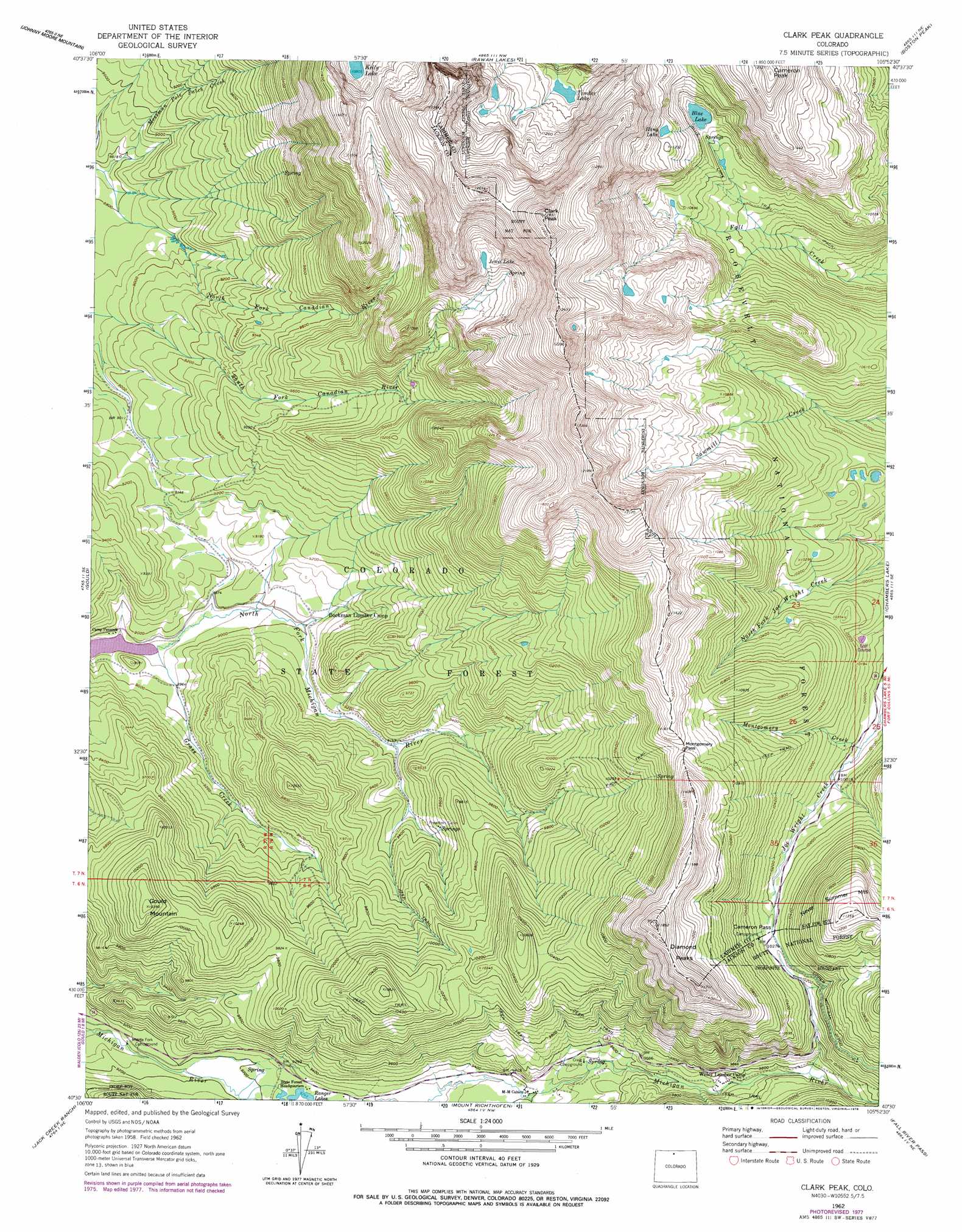
Clark Peak Topo Map Colorado
To zoom in, hover over the map of Clark Peak
USGS Topo Quad 40105e8 - 1:24,000 scale
| Topo Map Name: | Clark Peak |
| USGS Topo Quad ID: | 40105e8 |
| Print Size: | ca. 21 1/4" wide x 27" high |
| Southeast Coordinates: | 40.5° N latitude / 105.875° W longitude |
| Map Center Coordinates: | 40.5625° N latitude / 105.9375° W longitude |
| U.S. State: | CO |
| Filename: | o40105e8.jpg |
| Download Map JPG Image: | Clark Peak topo map 1:24,000 scale |
| Map Type: | Topographic |
| Topo Series: | 7.5´ |
| Map Scale: | 1:24,000 |
| Source of Map Images: | United States Geological Survey (USGS) |
| Alternate Map Versions: |
Clark Peak CO 1962, updated 1964 Download PDF Buy paper map Clark Peak CO 1962, updated 1964 Download PDF Buy paper map Clark Peak CO 1962, updated 1968 Download PDF Buy paper map Clark Peak CO 1962, updated 1968 Download PDF Buy paper map Clark Peak CO 1962, updated 1978 Download PDF Buy paper map Clark Peak CO 2000, updated 2004 Download PDF Buy paper map Clark Peak CO 2011 Download PDF Buy paper map Clark Peak CO 2013 Download PDF Buy paper map Clark Peak CO 2016 Download PDF Buy paper map |
| FStopo: | US Forest Service topo Clark Peak is available: Download FStopo PDF Download FStopo TIF |
1:24,000 Topo Quads surrounding Clark Peak
Eagle Hill |
Shipman Mountain |
Glendevey |
Deadman |
South Bald Mountain |
Gould Nw |
Johnny Moore Mountain |
Rawah Lakes |
Boston Peak |
Kinikinik |
Owl Ridge |
Gould |
Clark Peak |
Chambers Lake |
Comanche Peak |
Rand |
Jack Creek Ranch |
Mount Richthofen |
Fall River Pass |
Trail Ridge |
Parkview Mountain |
Radial Mountain |
Bowen Mountain |
Grand Lake |
Mchenrys Peak |
> Back to 40105e1 at 1:100,000 scale
> Back to 40104a1 at 1:250,000 scale
> Back to U.S. Topo Maps home
Clark Peak topo map: Gazetteer
Clark Peak: Forests
Colorado State Forest elevation 2930m 9612′Clark Peak: Gaps
Cameron Pass elevation 3124m 10249′Montgomery Pass elevation 3354m 11003′
Clark Peak: Lakes
Blue Lake elevation 3256m 10682′Hang Lake elevation 3399m 11151′
Jewel Lake elevation 3434m 11266′
Timber Lake elevation 3328m 10918′
Clark Peak: Populated Places
Bockman Lumber Camp elevation 2757m 9045′Willey Lumber Camp elevation 2950m 9678′
Clark Peak: Reservoirs
Ranger Lakes elevation 2819m 9248′Clark Peak: Streams
Grass Creek elevation 2719m 8920′Montgomery Creek elevation 3032m 9947′
Mossman Pole Patch Creek elevation 2667m 8750′
Clark Peak: Summits
Cameron Peak elevation 3695m 12122′Clark Peak elevation 3947m 12949′
Diamond Peaks elevation 3613m 11853′
Gould Mountain elevation 3165m 10383′
Clark Peak: Trails
Blue Lake Trail elevation 3185m 10449′Bockman Trail elevation 3154m 10347′
Montgomery Pass Trail elevation 3228m 10590′
Clark Peak digital topo map on disk
Buy this Clark Peak topo map showing relief, roads, GPS coordinates and other geographical features, as a high-resolution digital map file on DVD: