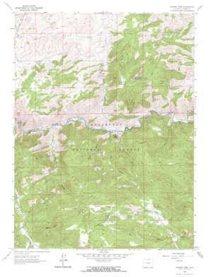
Poudre Park Topo Map Colorado
To zoom in, hover over the map of Poudre Park
USGS Topo Quad 40105f3 - 1:24,000 scale
| Topo Map Name: | Poudre Park |
| USGS Topo Quad ID: | 40105f3 |
| Print Size: | ca. 21 1/4" wide x 27" high |
| Southeast Coordinates: | 40.625° N latitude / 105.25° W longitude |
| Map Center Coordinates: | 40.6875° N latitude / 105.3125° W longitude |
| U.S. State: | CO |
| Filename: | o40105f3.jpg |
| Download Map JPG Image: | Poudre Park topo map 1:24,000 scale |
| Map Type: | Topographic |
| Topo Series: | 7.5´ |
| Map Scale: | 1:24,000 |
| Source of Map Images: | United States Geological Survey (USGS) |
| Alternate Map Versions: |
Poudre Park CO 1962, updated 1964 Download PDF Buy paper map Poudre Park CO 1962, updated 1969 Download PDF Buy paper map Poudre Park CO 2011 Download PDF Buy paper map Poudre Park CO 2013 Download PDF Buy paper map Poudre Park CO 2016 Download PDF Buy paper map |
| FStopo: | US Forest Service topo Poudre Park is available: Download FStopo PDF Download FStopo TIF |
1:24,000 Topo Quads surrounding Poudre Park
> Back to 40105e1 at 1:100,000 scale
> Back to 40104a1 at 1:250,000 scale
> Back to U.S. Topo Maps home
Poudre Park topo map: Gazetteer
Poudre Park: Flats
Greyrock Meadow elevation 2047m 6715′Stratton Park elevation 2217m 7273′
Poudre Park: Mines
Alice M Beryl Mine elevation 2290m 7513′Beryl Dike Claim elevation 2271m 7450′
Beryl Number Three Claim elevation 2265m 7431′
Beryl Number Two Mine elevation 2271m 7450′
Brinkhoff Mine elevation 2115m 6938′
Glen O Barrett Mine elevation 2317m 7601′
Green Crystals Number Three Claim elevation 2372m 7782′
Green Cystals Number Four Claim elevation 2372m 7782′
Green Rock Mine elevation 1842m 6043′
Hanks Hole Claims elevation 2257m 7404′
HE and M Number Nine Claim elevation 2397m 7864′
HG and J Number Fifteen Claim elevation 2188m 7178′
HG and J Number Three Claim elevation 2176m 7139′
HG and J Number Twenty-three Claim elevation 2188m 7178′
Langston Pit elevation 1741m 5711′
Mount Ethyl Beryl Claim elevation 2435m 7988′
Spaulding Mine elevation 1805m 5921′
Valley View Claims Number 142 elevation 2346m 7696′
Vona Mae Mine elevation 1939m 6361′
Poudre Park: Populated Places
Mishawaka elevation 1792m 5879′Poudre Park elevation 1730m 5675′
Poudre Park: Streams
Gordon Creek elevation 1724m 5656′Poudre Park: Summits
Greyrock Mountain elevation 2297m 7536′Mount Ethel elevation 2578m 8458′
Poudre Park: Trails
Greyrock Trail elevation 1877m 6158′Wintersteen Trail elevation 2100m 6889′
Poudre Park: Valleys
Boyd Gulch elevation 1667m 5469′Falls Gulch elevation 1733m 5685′
Harlan Gulch elevation 2178m 7145′
Hewlett Gulch elevation 1726m 5662′
Hill Gulch elevation 1727m 5666′
Little Narrows elevation 1798m 5898′
Stove Prairie Gulch elevation 2142m 7027′
Watha Gulch elevation 1746m 5728′
Young Gulch elevation 1776m 5826′
Poudre Park digital topo map on disk
Buy this Poudre Park topo map showing relief, roads, GPS coordinates and other geographical features, as a high-resolution digital map file on DVD:


