Livermore Topo Map Colorado
To zoom in, hover over the map of Livermore
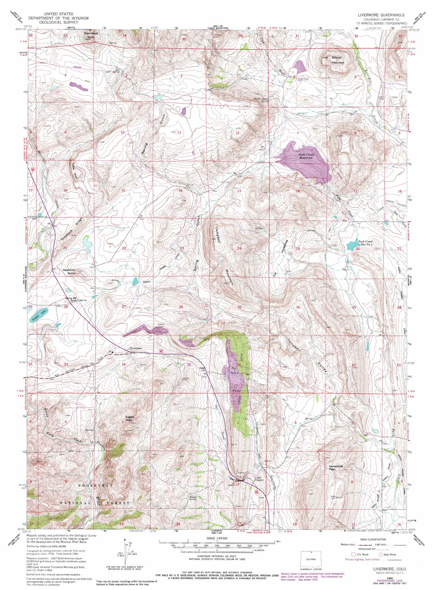
USGS Topo Quad 40105g2 - 1:24,000 scale
| Topo Map Name: | Livermore |
| USGS Topo Quad ID: | 40105g2 |
| Print Size: | ca. 21 1/4" wide x 27" high |
| Southeast Coordinates: | 40.75° N latitude / 105.125° W longitude |
| Map Center Coordinates: | 40.8125° N latitude / 105.1875° W longitude |
| U.S. State: | CO |
| Filename: | o40105g2.jpg |
| Download Map JPG Image: | Livermore topo map 1:24,000 scale |
| Map Type: | Topographic |
| Topo Series: | 7.5´ |
| Map Scale: | 1:24,000 |
| Source of Map Images: | United States Geological Survey (USGS) |
| Alternate Map Versions: |
Livermore CO 1960, updated 1962 Download PDF Buy paper map Livermore CO 1960, updated 1966 Download PDF Buy paper map Livermore CO 1960, updated 1966 Download PDF Buy paper map Livermore CO 1960, updated 1979 Download PDF Buy paper map Livermore CO 2011 Download PDF Buy paper map Livermore CO 2013 Download PDF Buy paper map Livermore CO 2016 Download PDF Buy paper map |
| FStopo: | US Forest Service topo Livermore is available: Download FStopo PDF Download FStopo TIF |
1:24,000 Topo Quads surrounding Livermore
Dale Creek |
Buford |
Granite |
Emkay |
Borie |
Cherokee Park |
Virginia Dale |
Table Mountain |
Round Butte |
Carr West |
Haystack Gulch |
Livermore Mountain |
Livermore |
Buckeye |
Carr Sw |
Big Narrows |
Poudre Park |
Laporte |
Wellington |
Cobb Lake |
Crystal Mountain |
Buckhorn Mountain |
Horsetooth Reservoir |
Fort Collins |
Timnath |
> Back to 40105e1 at 1:100,000 scale
> Back to 40104a1 at 1:250,000 scale
> Back to U.S. Topo Maps home
Livermore topo map: Gazetteer
Livermore: Areas
Piñon Grove elevation 1834m 6017′Livermore: Basins
The Horseshoe elevation 1746m 5728′Livermore: Canals
North Poudre Ditch elevation 1809m 5935′Livermore: Dams
Park Creek Dam elevation 1715m 5626′Park Creek Number 2 Dam elevation 1714m 5623′
Slab Canyon Dam elevation 1783m 5849′
Livermore: Gaps
Horsethief Pass elevation 1778m 5833′Livermore: Lakes
Tibbits Lake elevation 1777m 5830′Livermore: Mines
Davis Nickel Prospect elevation 1892m 6207′Deadman Butte Mine elevation 1837m 6026′
Owl Canyon Mine elevation 1787m 5862′
Rex Quarry elevation 1865m 6118′
Roberts Quarry elevation 1857m 6092′
Livermore: Populated Places
Livermore elevation 1797m 5895′Owl Canyon elevation 1750m 5741′
Rex elevation 1805m 5921′
Livermore: Reservoirs
Park Creek Reservoir elevation 1715m 5626′Park Creek Reservoir Number 2 elevation 1714m 5623′
Slab Canyon Reservoir elevation 1783m 5849′
Livermore: Ridges
Grayback Ridge elevation 1873m 6145′Livermore: Springs
Bonner Spring elevation 1841m 6040′Box Spring elevation 1927m 6322′
Rufner Camp Spring elevation 1825m 5987′
Livermore: Summits
Bobcat Mountain elevation 1913m 6276′Campbell Mountain elevation 1947m 6387′
Deadman Butte elevation 1852m 6076′
Eagles Nest elevation 1916m 6286′
Gage Hill elevation 1839m 6033′
Steamboat Rock elevation 2075m 6807′
Table Rock elevation 1943m 6374′
Livermore: Valleys
Campbell Valley elevation 1655m 5429′Owl Canyon elevation 1749m 5738′
Slab Canyon Wash elevation 1794m 5885′
Spring Gulch elevation 1748m 5734′
Livermore: Wells
Roller Stone Well elevation 1785m 5856′Livermore digital topo map on disk
Buy this Livermore topo map showing relief, roads, GPS coordinates and other geographical features, as a high-resolution digital map file on DVD: