Deadman Topo Map Colorado
To zoom in, hover over the map of Deadman
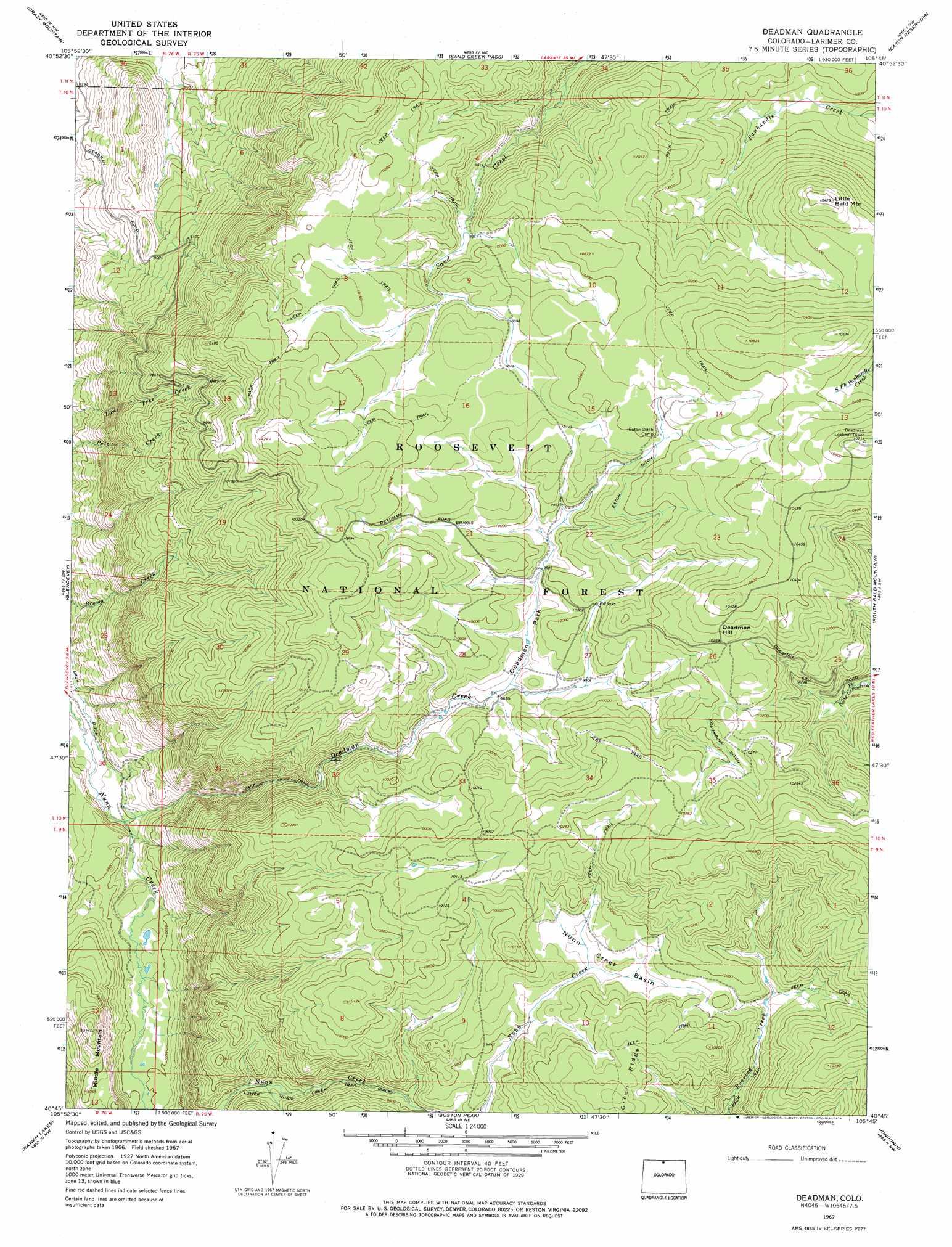
USGS Topo Quad 40105g7 - 1:24,000 scale
| Topo Map Name: | Deadman |
| USGS Topo Quad ID: | 40105g7 |
| Print Size: | ca. 21 1/4" wide x 27" high |
| Southeast Coordinates: | 40.75° N latitude / 105.75° W longitude |
| Map Center Coordinates: | 40.8125° N latitude / 105.8125° W longitude |
| U.S. State: | CO |
| Filename: | o40105g7.jpg |
| Download Map JPG Image: | Deadman topo map 1:24,000 scale |
| Map Type: | Topographic |
| Topo Series: | 7.5´ |
| Map Scale: | 1:24,000 |
| Source of Map Images: | United States Geological Survey (USGS) |
| Alternate Map Versions: |
Deadman CO 1967, updated 1971 Download PDF Buy paper map Deadman CO 1967, updated 1971 Download PDF Buy paper map Deadman CO 1967, updated 1974 Download PDF Buy paper map Deadman CO 1967, updated 1974 Download PDF Buy paper map Deadman Park CO 2011 Download PDF Buy paper map Deadman Park CO 2013 Download PDF Buy paper map Deadman Park CO 2016 Download PDF Buy paper map |
| FStopo: | US Forest Service topo Deadman is available: Download FStopo PDF Download FStopo TIF |
1:24,000 Topo Quads surrounding Deadman
Woods Landing |
Jelm Mountain |
Downey Lakes |
Johnson Ranch |
Best Ranch |
Old Roach |
Crazy Mountain |
Sand Creek Pass |
Eaton Reservoir |
Diamond Peak |
Shipman Mountain |
Glendevey |
Deadman |
South Bald Mountain |
Red Feather Lakes |
Johnny Moore Mountain |
Rawah Lakes |
Boston Peak |
Kinikinik |
Rustic |
Gould |
Clark Peak |
Chambers Lake |
Comanche Peak |
Pingree Park |
> Back to 40105e1 at 1:100,000 scale
> Back to 40104a1 at 1:250,000 scale
> Back to U.S. Topo Maps home
Deadman topo map: Gazetteer
Deadman: Basins
Nunn Creek Basin elevation 3023m 9917′Deadman: Canals
Columbine Ditch elevation 3113m 10213′Deadman: Streams
Deadman Creek elevation 2555m 8382′Deadman: Summits
Deadman Hill elevation 3196m 10485′Little Bald Mountain elevation 3175m 10416′
Middle Mountain elevation 2835m 9301′
Deadman: Trails
Lower Nunn Creek Trail elevation 2820m 9251′Deadman digital topo map on disk
Buy this Deadman topo map showing relief, roads, GPS coordinates and other geographical features, as a high-resolution digital map file on DVD: