Diamond Peak Topo Map Colorado
To zoom in, hover over the map of Diamond Peak
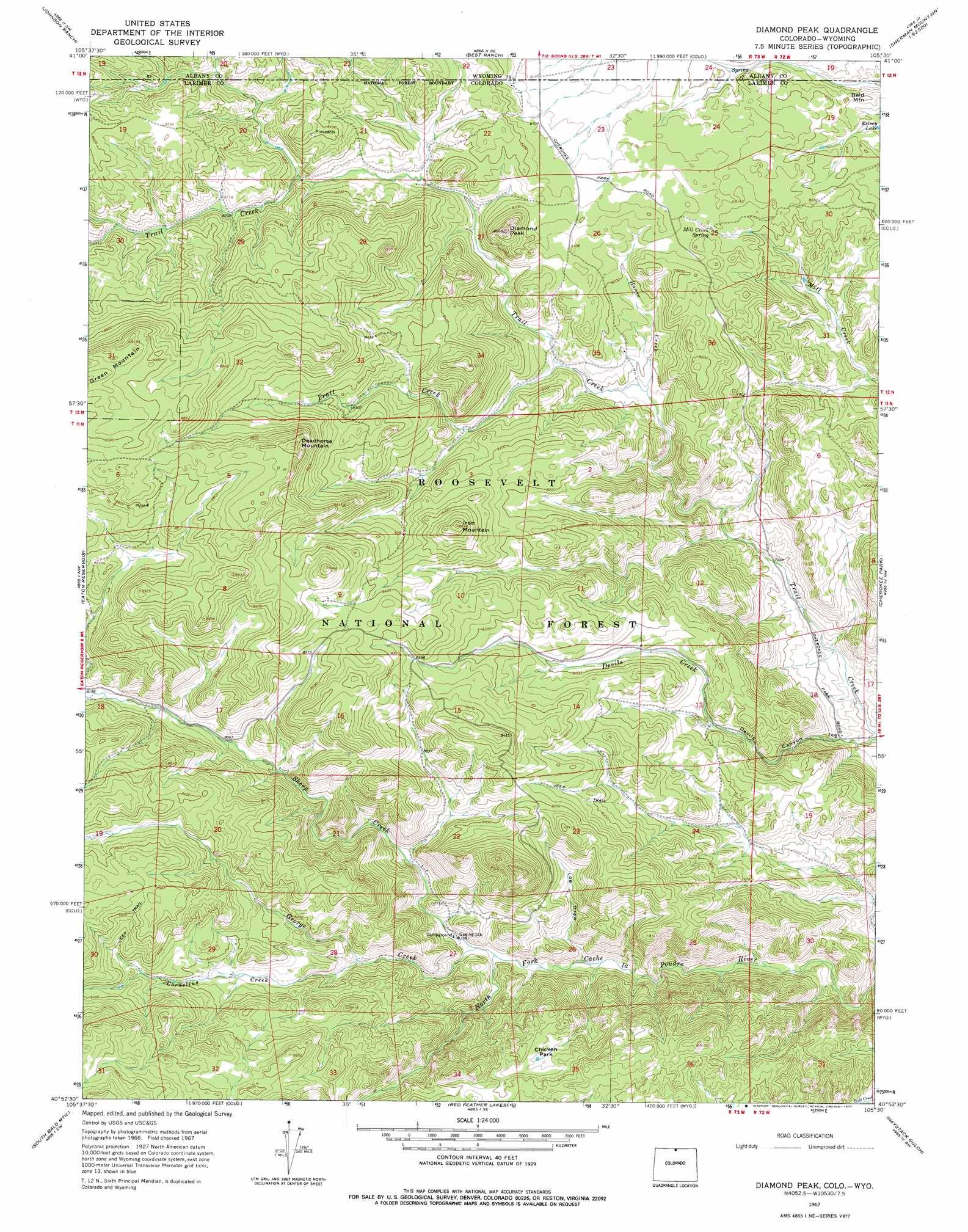
USGS Topo Quad 40105h5 - 1:24,000 scale
| Topo Map Name: | Diamond Peak |
| USGS Topo Quad ID: | 40105h5 |
| Print Size: | ca. 21 1/4" wide x 27" high |
| Southeast Coordinates: | 40.875° N latitude / 105.5° W longitude |
| Map Center Coordinates: | 40.9375° N latitude / 105.5625° W longitude |
| U.S. States: | CO, WY |
| Filename: | o40105h5.jpg |
| Download Map JPG Image: | Diamond Peak topo map 1:24,000 scale |
| Map Type: | Topographic |
| Topo Series: | 7.5´ |
| Map Scale: | 1:24,000 |
| Source of Map Images: | United States Geological Survey (USGS) |
| Alternate Map Versions: |
Diamond Peak CO 1967, updated 1971 Download PDF Buy paper map Diamond Peak CO 1967, updated 1971 Download PDF Buy paper map Diamond Peak CO 1967, updated 1977 Download PDF Buy paper map Diamond Peak CO 2011 Download PDF Buy paper map Diamond Peak CO 2013 Download PDF Buy paper map Diamond Peak CO 2016 Download PDF Buy paper map |
| FStopo: | US Forest Service topo Diamond Peak is available: Download FStopo PDF Download FStopo TIF |
1:24,000 Topo Quads surrounding Diamond Peak
Caldwell Lake |
Hutton Lake |
Red Buttes |
Sherman Mountains West |
Sherman Mountains East |
Downey Lakes |
Johnson Ranch |
Best Ranch |
Dale Creek |
Buford |
Sand Creek Pass |
Eaton Reservoir |
Diamond Peak |
Cherokee Park |
Virginia Dale |
Deadman |
South Bald Mountain |
Red Feather Lakes |
Haystack Gulch |
Livermore Mountain |
Boston Peak |
Kinikinik |
Rustic |
Big Narrows |
Poudre Park |
> Back to 40105e1 at 1:100,000 scale
> Back to 40104a1 at 1:250,000 scale
> Back to U.S. Topo Maps home
Diamond Peak topo map: Gazetteer
Diamond Peak: Flats
Chicken Park elevation 2459m 8067′Diamond Peak: Reservoirs
Kelsey Lake elevation 2394m 7854′Diamond Peak: Springs
Mill Creek Spring elevation 2463m 8080′Diamond Peak: Streams
Cornelius Creek elevation 2393m 7851′George Creek elevation 2306m 7565′
Hanse Creek elevation 2362m 7749′
Pratt Creek elevation 2384m 7821′
Sheep Creek elevation 2306m 7565′
Diamond Peak: Summits
Bald Mountain elevation 2442m 8011′Deadhorse Mountain elevation 2762m 9061′
Diamond Peak elevation 2621m 8599′
Iron Mountain elevation 2649m 8690′
Diamond Peak: Valleys
Devils Canyon elevation 2230m 7316′Log Draw elevation 2323m 7621′
Diamond Peak digital topo map on disk
Buy this Diamond Peak topo map showing relief, roads, GPS coordinates and other geographical features, as a high-resolution digital map file on DVD: