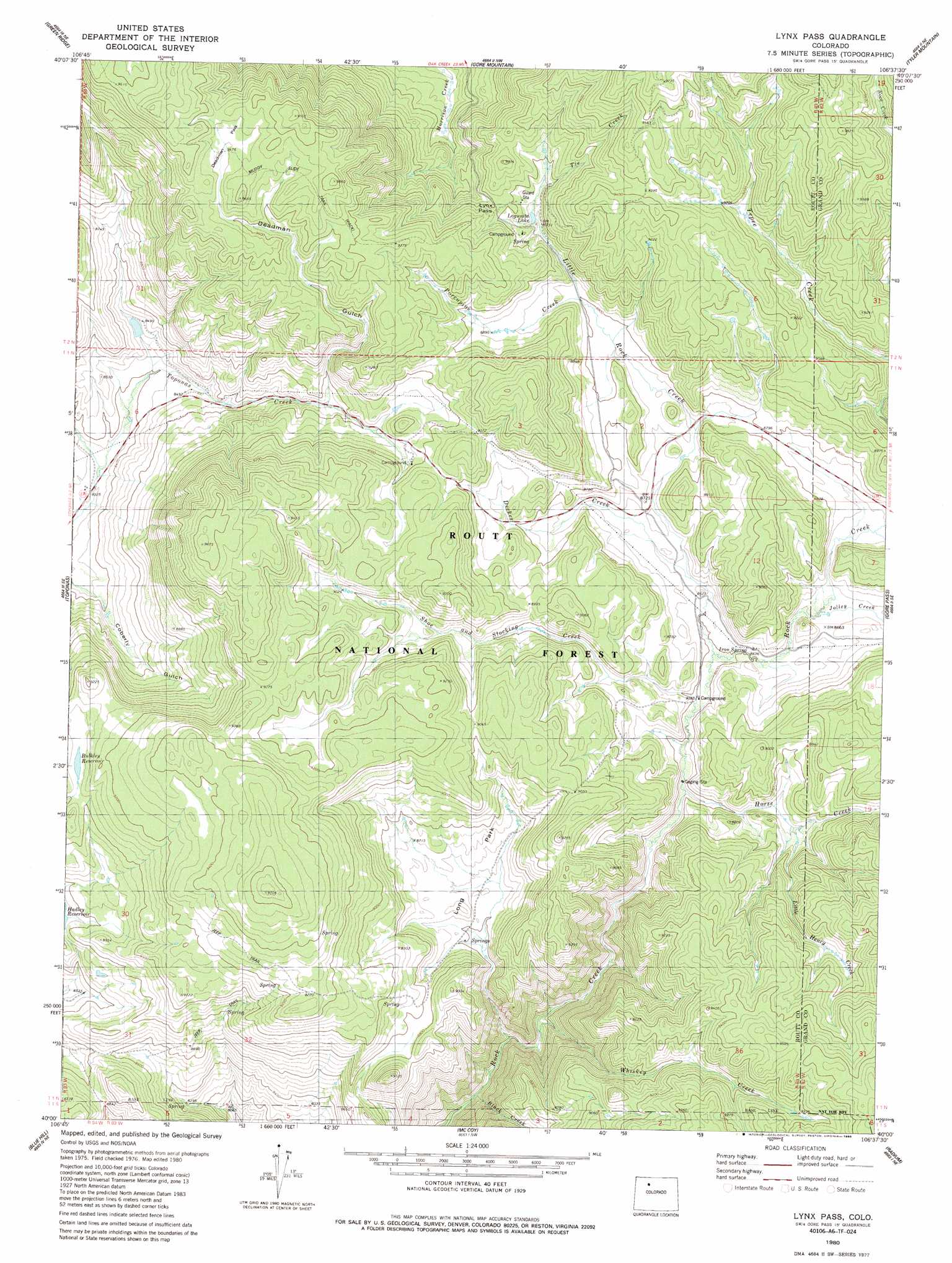
Lynx Pass Topo Map Colorado
To zoom in, hover over the map of Lynx Pass
USGS Topo Quad 40106a6 - 1:24,000 scale
| Topo Map Name: | Lynx Pass |
| USGS Topo Quad ID: | 40106a6 |
| Print Size: | ca. 21 1/4" wide x 27" high |
| Southeast Coordinates: | 40° N latitude / 106.625° W longitude |
| Map Center Coordinates: | 40.0625° N latitude / 106.6875° W longitude |
| U.S. State: | CO |
| Filename: | o40106a6.jpg |
| Download Map JPG Image: | Lynx Pass topo map 1:24,000 scale |
| Map Type: | Topographic |
| Topo Series: | 7.5´ |
| Map Scale: | 1:24,000 |
| Source of Map Images: | United States Geological Survey (USGS) |
| Alternate Map Versions: |
Lynx Pass CO 1980, updated 1980 Download PDF Buy paper map Lynx Pass CO 1980, updated 1986 Download PDF Buy paper map Lynx Pass CO 1980, updated 1986 Download PDF Buy paper map Lynx Pass CO 1980, updated 1986 Download PDF Buy paper map Lynx Pass CO 2000, updated 2004 Download PDF Buy paper map Lynx Pass CO 2011 Download PDF Buy paper map Lynx Pass CO 2013 Download PDF Buy paper map Lynx Pass CO 2016 Download PDF Buy paper map |
| FStopo: | US Forest Service topo Lynx Pass is available: Download FStopo PDF Download FStopo TIF |
1:24,000 Topo Quads surrounding Lynx Pass
Oak Creek |
Blacktail Mountain |
Walton Peak |
Lake Agnes |
Whiteley Peak |
Yampa |
Green Ridge |
Gore Mountain |
Tyler Mountain |
Hinman Reservoir |
Trapper |
Toponas |
Lynx Pass |
Gore Pass |
Kremmling |
Burns North |
Blue Hill |
Mccoy |
Radium |
Sheephorn Mountain |
Burns South |
Castle Peak |
State Bridge |
Lava Creek |
Piney Peak |
> Back to 40106a1 at 1:100,000 scale
> Back to 40106a1 at 1:250,000 scale
> Back to U.S. Topo Maps home
Lynx Pass topo map: Gazetteer
Lynx Pass: Canals
Allen Ditch elevation 2858m 9376′Maggie Ditch elevation 2836m 9304′
Lynx Pass: Dams
Bulkley Dam elevation 2751m 9025′Morris Dam elevation 2751m 9025′
Tonier Gulch Dam elevation 2593m 8507′
Lynx Pass: Flats
Deadman Park elevation 2891m 9484′Long Park elevation 2645m 8677′
Lynx Pass: Gaps
Lynx Pass elevation 2729m 8953′Lynx Pass: Lakes
Lagunita Lake elevation 2722m 8930′Lynx Pass: Reservoirs
Bulkley Reservoir elevation 2751m 9025′Morris Reservoir elevation 2751m 9025′
Reid Reservoir elevation 2653m 8704′
Tonier Gulch Reservoir elevation 2593m 8507′
Lynx Pass: Springs
Iron Spring elevation 2623m 8605′Lynx Pass: Streams
Black Creek elevation 2422m 7946′Decker Creek elevation 2631m 8631′
Horse Creek elevation 2608m 8556′
Jolley Creek elevation 2634m 8641′
Little Henry Creek elevation 2646m 8681′
Little Rock Creek elevation 2622m 8602′
Porcupine Creek elevation 2684m 8805′
Shoe and Stocking Creek elevation 2621m 8599′
Tepee Creek elevation 2709m 8887′
Tie Creek elevation 2731m 8959′
Whiskey Creek elevation 2466m 8090′
Lynx Pass: Trails
Morrison Divide Trail elevation 2903m 9524′Tepee Creek Trail elevation 2807m 9209′
Lynx Pass: Valleys
Deadman Gulch elevation 2667m 8750′Lynx Pass digital topo map on disk
Buy this Lynx Pass topo map showing relief, roads, GPS coordinates and other geographical features, as a high-resolution digital map file on DVD: