Trapper Topo Map Colorado
To zoom in, hover over the map of Trapper
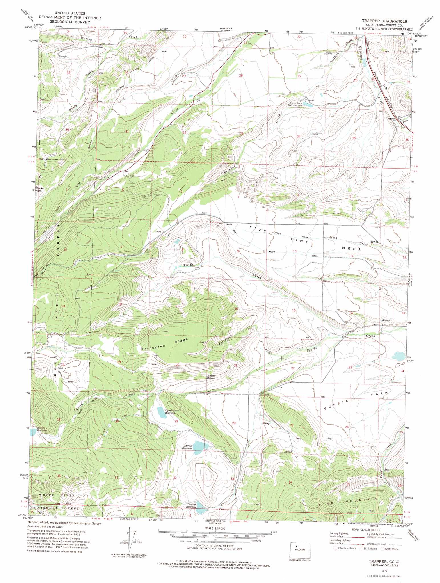
USGS Topo Quad 40106a8 - 1:24,000 scale
| Topo Map Name: | Trapper |
| USGS Topo Quad ID: | 40106a8 |
| Print Size: | ca. 21 1/4" wide x 27" high |
| Southeast Coordinates: | 40° N latitude / 106.875° W longitude |
| Map Center Coordinates: | 40.0625° N latitude / 106.9375° W longitude |
| U.S. State: | CO |
| Filename: | o40106a8.jpg |
| Download Map JPG Image: | Trapper topo map 1:24,000 scale |
| Map Type: | Topographic |
| Topo Series: | 7.5´ |
| Map Scale: | 1:24,000 |
| Source of Map Images: | United States Geological Survey (USGS) |
| Alternate Map Versions: |
Trapper CO 1972, updated 1975 Download PDF Buy paper map Trapper CO 1972, updated 1975 Download PDF Buy paper map Trapper CO 2000, updated 2004 Download PDF Buy paper map Trapper CO 2011 Download PDF Buy paper map Trapper CO 2013 Download PDF Buy paper map Trapper CO 2016 Download PDF Buy paper map |
| FStopo: | US Forest Service topo Trapper is available: Download FStopo PDF Download FStopo TIF |
1:24,000 Topo Quads surrounding Trapper
Dunckley |
Rattlesnake Butte |
Oak Creek |
Blacktail Mountain |
Walton Peak |
Dunckley Pass |
Sand Point |
Yampa |
Green Ridge |
Gore Mountain |
Devils Causeway |
Orno Peak |
Trapper |
Toponas |
Lynx Pass |
Trappers Lake |
Dome Peak |
Burns North |
Blue Hill |
Mccoy |
Sweetwater Lake |
Sugarloaf Mountain |
Burns South |
Castle Peak |
State Bridge |
> Back to 40106a1 at 1:100,000 scale
> Back to 40106a1 at 1:250,000 scale
> Back to U.S. Topo Maps home
Trapper topo map: Gazetteer
Trapper: Canals
Five Pine Mesa Ditch elevation 2702m 8864′Roaring Fork Ditch elevation 2722m 8930′
Trapper: Dams
Egeria Dam elevation 2773m 9097′Harper and Sons Dam elevation 3004m 9855′
Newton Gulch Dam elevation 2612m 8569′
Roberta Dam elevation 2554m 8379′
Sterner Dam elevation 2762m 9061′
Trapper: Populated Places
Trapper elevation 2444m 8018′Trapper: Reservoirs
Crossan Reservoir elevation 2756m 9041′Egeria Creek Reservoir elevation 2772m 9094′
Harper and Sons Reservoir elevation 3004m 9855′
Harper Reservoir elevation 3004m 9855′
Newton Gulch Reservoir elevation 2612m 8569′
Roberta Reservoir elevation 2554m 8379′
Sterner Reservoir elevation 2762m 9061′
Trapper: Ridges
Porcupine Ridge elevation 2907m 9537′Trapper: Springs
Harper Spring elevation 2756m 9041′Trapper: Streams
Bear River elevation 2631m 8631′Beaver Creek elevation 2447m 8028′
Brinker Creek elevation 2425m 7956′
Chimney Creek elevation 2422m 7946′
Moody Creek elevation 2485m 8152′
Moore Park Creek elevation 2509m 8231′
Porcupine Creek elevation 2597m 8520′
Smith Creek elevation 2559m 8395′
Todd Creek elevation 2436m 7992′
Trapper: Summits
Five Pine Mesa elevation 2715m 8907′Trapper digital topo map on disk
Buy this Trapper topo map showing relief, roads, GPS coordinates and other geographical features, as a high-resolution digital map file on DVD: