Green Ridge Topo Map Colorado
To zoom in, hover over the map of Green Ridge
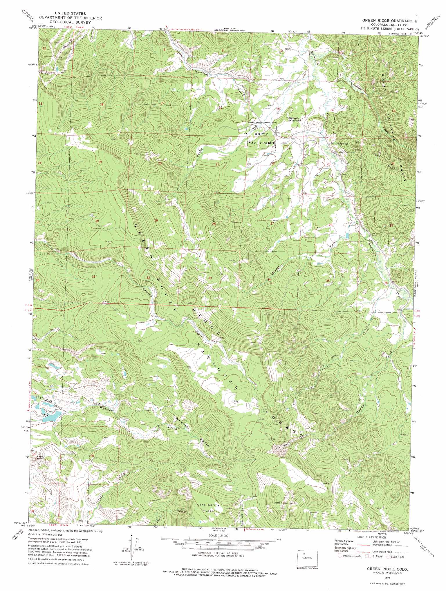
USGS Topo Quad 40106b7 - 1:24,000 scale
| Topo Map Name: | Green Ridge |
| USGS Topo Quad ID: | 40106b7 |
| Print Size: | ca. 21 1/4" wide x 27" high |
| Southeast Coordinates: | 40.125° N latitude / 106.75° W longitude |
| Map Center Coordinates: | 40.1875° N latitude / 106.8125° W longitude |
| U.S. State: | CO |
| Filename: | o40106b7.jpg |
| Download Map JPG Image: | Green Ridge topo map 1:24,000 scale |
| Map Type: | Topographic |
| Topo Series: | 7.5´ |
| Map Scale: | 1:24,000 |
| Source of Map Images: | United States Geological Survey (USGS) |
| Alternate Map Versions: |
Green Ridge CO 1972, updated 1975 Download PDF Buy paper map Green Ridge CO 1972, updated 1975 Download PDF Buy paper map Green Ridge CO 2000, updated 2004 Download PDF Buy paper map Green Ridge CO 2011 Download PDF Buy paper map Green Ridge CO 2013 Download PDF Buy paper map Green Ridge CO 2016 Download PDF Buy paper map |
| FStopo: | US Forest Service topo Green Ridge is available: Download FStopo PDF Download FStopo TIF |
1:24,000 Topo Quads surrounding Green Ridge
Milner |
Cow Creek |
Steamboat Springs |
Mount Werner |
Rabbit Ears Peak |
Rattlesnake Butte |
Oak Creek |
Blacktail Mountain |
Walton Peak |
Lake Agnes |
Sand Point |
Yampa |
Green Ridge |
Gore Mountain |
Tyler Mountain |
Orno Peak |
Trapper |
Toponas |
Lynx Pass |
Gore Pass |
Dome Peak |
Burns North |
Blue Hill |
Mccoy |
Radium |
> Back to 40106a1 at 1:100,000 scale
> Back to 40106a1 at 1:250,000 scale
> Back to U.S. Topo Maps home
Green Ridge topo map: Gazetteer
Green Ridge: Basins
Wheeler Basin elevation 2780m 9120′Green Ridge: Dams
Bar-Bee Lake Dam elevation 2454m 8051′Lake Creek Dam elevation 2495m 8185′
Green Ridge: Lakes
Eagle Rock Lakes elevation 2507m 8225′Green Ridge: Reservoirs
Bar-Bee Lake Reservoir elevation 2454m 8051′Lake Creek Reservoir elevation 2495m 8185′
Green Ridge: Ridges
Green Ridge elevation 3006m 9862′Green Ridge: Streams
Beaver Creek elevation 2439m 8001′Bushy Creek elevation 2408m 7900′
Bussy Creek elevation 2408m 7900′
Clear Creek elevation 2451m 8041′
Ranger Creek elevation 3085m 10121′
Silver Creek elevation 2403m 7883′
Green Ridge: Summits
Eagle Rock elevation 2634m 8641′Lone Spring Butte elevation 3126m 10255′
Simpson Mountain elevation 2465m 8087′
Green Ridge: Trails
Muddy Slide Trail elevation 2982m 9783′Silver Creek Trail elevation 2424m 7952′
Green Ridge: Valleys
The Slide elevation 2844m 9330′Green Ridge digital topo map on disk
Buy this Green Ridge topo map showing relief, roads, GPS coordinates and other geographical features, as a high-resolution digital map file on DVD: