Radial Mountain Topo Map Colorado
To zoom in, hover over the map of Radial Mountain
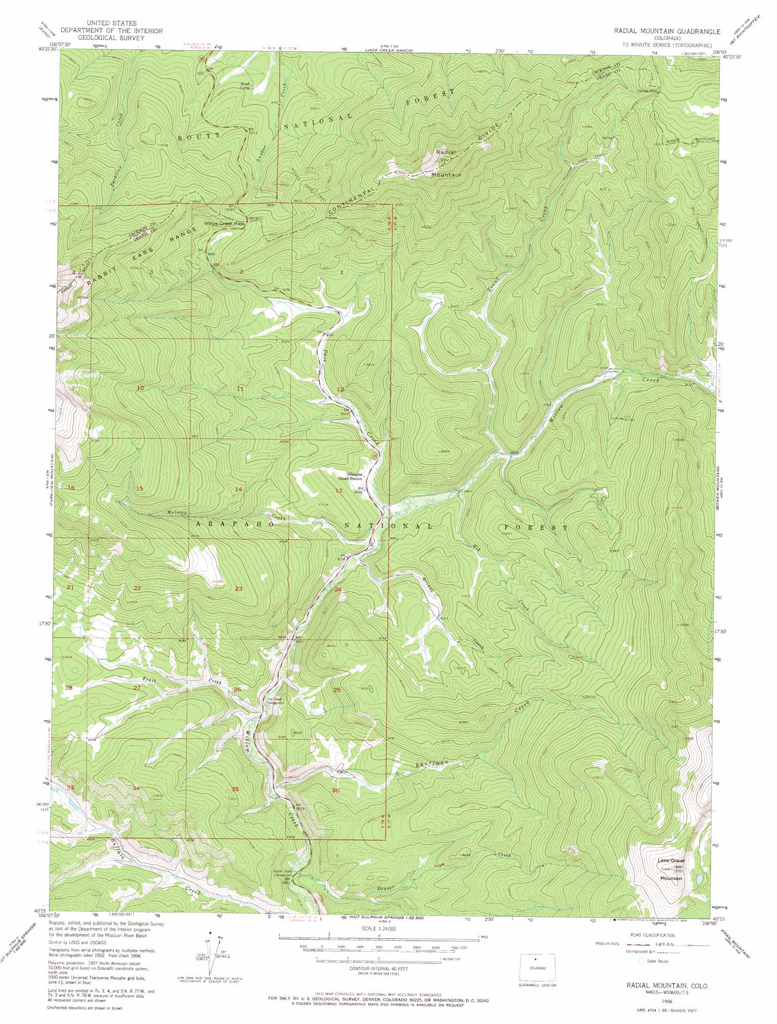
USGS Topo Quad 40106c1 - 1:24,000 scale
| Topo Map Name: | Radial Mountain |
| USGS Topo Quad ID: | 40106c1 |
| Print Size: | ca. 21 1/4" wide x 27" high |
| Southeast Coordinates: | 40.25° N latitude / 106° W longitude |
| Map Center Coordinates: | 40.3125° N latitude / 106.0625° W longitude |
| U.S. State: | CO |
| Filename: | o40106c1.jpg |
| Download Map JPG Image: | Radial Mountain topo map 1:24,000 scale |
| Map Type: | Topographic |
| Topo Series: | 7.5´ |
| Map Scale: | 1:24,000 |
| Source of Map Images: | United States Geological Survey (USGS) |
| Alternate Map Versions: |
Radial Mountain CO 1956, updated 1957 Download PDF Buy paper map Radial Mountain CO 1956, updated 1957 Download PDF Buy paper map Radial Mountain CO 1956, updated 1963 Download PDF Buy paper map Radial Mountain CO 1956, updated 1969 Download PDF Buy paper map Radial Mountain CO 2011 Download PDF Buy paper map Radial Mountain CO 2013 Download PDF Buy paper map Radial Mountain CO 2016 Download PDF Buy paper map |
| FStopo: | US Forest Service topo Radial Mountain is available: Download FStopo PDF Download FStopo TIF |
1:24,000 Topo Quads surrounding Radial Mountain
Macfarlane Reservoir |
Owl Ridge |
Gould |
Clark Peak |
Chambers Lake |
Buffalo Peak |
Rand |
Jack Creek Ranch |
Mount Richthofen |
Fall River Pass |
Hyannis Peak |
Parkview Mountain |
Radial Mountain |
Bowen Mountain |
Grand Lake |
Gunsight Pass |
Corral Peaks |
Cabin Creek |
Trail Mountain |
Shadow Mountain |
Junction Butte |
Parshall |
Hot Sulpher Springs |
Granby |
Strawberry Lake |
> Back to 40106a1 at 1:100,000 scale
> Back to 40106a1 at 1:250,000 scale
> Back to U.S. Topo Maps home
Radial Mountain topo map: Gazetteer
Radial Mountain: Dams
Little King Ranch Dam elevation 2699m 8854′Radial Mountain: Gaps
Illinois Pass elevation 3058m 10032′Willow Creek Pass elevation 2944m 9658′
Radial Mountain: Mines
Big Dike Lode elevation 2966m 9730′Radial Mountain: Reservoirs
Little King Ranch Reservoir elevation 2699m 8854′Radial Mountain: Streams
Bronco Creek elevation 2725m 8940′Denver Creek elevation 2616m 8582′
Elk Creek elevation 2704m 8871′
Kauffman Creek elevation 2631m 8631′
Mulstay Creek elevation 2682m 8799′
Pass Creek elevation 2684m 8805′
South Fork Buffalo Creek elevation 2683m 8802′
Trail Creek elevation 2647m 8684′
Trout Creek elevation 2707m 8881′
Radial Mountain: Summits
Little Gravel Mountain elevation 3505m 11499′Radial Mountain elevation 3426m 11240′
Radial Mountain: Trails
Bill Creek Trail elevation 3015m 9891′Willow Pass Trail elevation 2806m 9206′
Radial Mountain digital topo map on disk
Buy this Radial Mountain topo map showing relief, roads, GPS coordinates and other geographical features, as a high-resolution digital map file on DVD: