Mount Werner Topo Map Colorado
To zoom in, hover over the map of Mount Werner
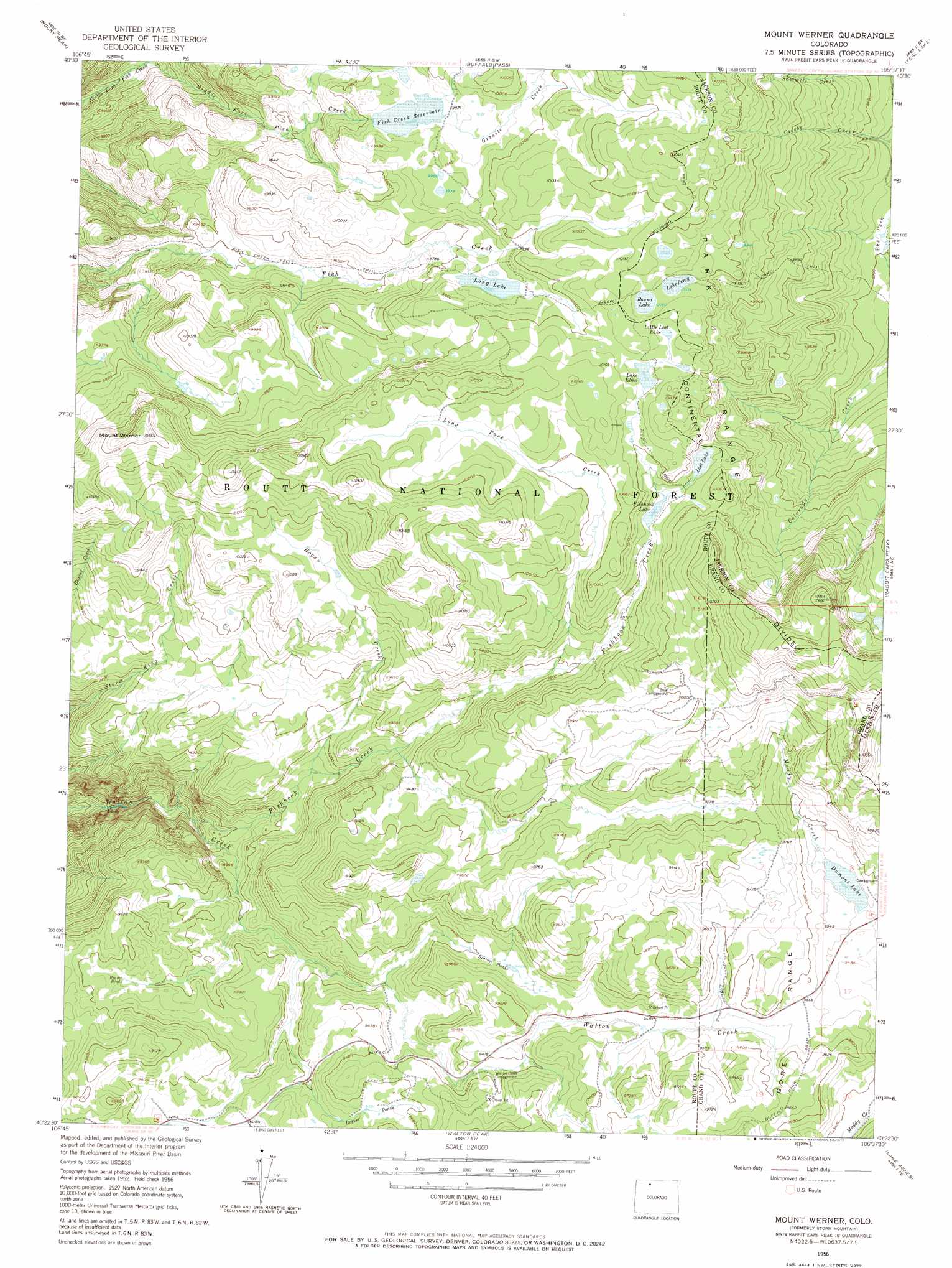
USGS Topo Quad 40106d6 - 1:24,000 scale
| Topo Map Name: | Mount Werner |
| USGS Topo Quad ID: | 40106d6 |
| Print Size: | ca. 21 1/4" wide x 27" high |
| Southeast Coordinates: | 40.375° N latitude / 106.625° W longitude |
| Map Center Coordinates: | 40.4375° N latitude / 106.6875° W longitude |
| U.S. State: | CO |
| Filename: | o40106d6.jpg |
| Download Map JPG Image: | Mount Werner topo map 1:24,000 scale |
| Map Type: | Topographic |
| Topo Series: | 7.5´ |
| Map Scale: | 1:24,000 |
| Source of Map Images: | United States Geological Survey (USGS) |
| Alternate Map Versions: |
Storm Mountain CO 1956, updated 1958 Download PDF Buy paper map Storm Mountain CO 1956, updated 1963 Download PDF Buy paper map Mount Werner CO 1956, updated 1972 Download PDF Buy paper map Mount Werner CO 1956, updated 1972 Download PDF Buy paper map Mount Werner CO 2000, updated 2004 Download PDF Buy paper map Mount Werner CO 2011 Download PDF Buy paper map Mount Werner CO 2013 Download PDF Buy paper map Mount Werner CO 2016 Download PDF Buy paper map |
| FStopo: | US Forest Service topo Mount Werner is available: Download FStopo PDF Download FStopo TIF |
1:24,000 Topo Quads surrounding Mount Werner
Clark |
Floyd Peak |
Mount Ethel |
Pitchpine Mountain |
Delaney Butte |
Mad Creek |
Rocky Peak |
Buffalo Pass |
Teal Lake |
Coalmont |
Cow Creek |
Steamboat Springs |
Mount Werner |
Rabbit Ears Peak |
Spicer Peak |
Oak Creek |
Blacktail Mountain |
Walton Peak |
Lake Agnes |
Whiteley Peak |
Yampa |
Green Ridge |
Gore Mountain |
Tyler Mountain |
Hinman Reservoir |
> Back to 40106a1 at 1:100,000 scale
> Back to 40106a1 at 1:250,000 scale
> Back to U.S. Topo Maps home
Mount Werner topo map: Gazetteer
Mount Werner: Airports
Mount Werner Heliport elevation 3088m 10131′Mount Werner: Dams
Long Lake Dam elevation 3004m 9855′Muddy Creek Dam elevation 2901m 9517′
Mount Werner: Lakes
Fishhook Lake elevation 3012m 9881′Lake Elmo elevation 3061m 10042′
Lake Percy elevation 3060m 10039′
Little Lost Lake elevation 3071m 10075′
Long Lake elevation 3004m 9855′
Lost Lake elevation 3019m 9904′
Round Lake elevation 3068m 10065′
Mount Werner: Reservoirs
Dumont Lake elevation 2900m 9514′Fish Creek Reservoir elevation 3006m 9862′
Long Lake Reservoir elevation 3004m 9855′
Mount Werner: Streams
Butcherknife Creek elevation 3101m 10173′Fishhook Creek elevation 2573m 8441′
Granite Creek elevation 3007m 9865′
Hogan Creek elevation 2767m 9078′
Long Park Creek elevation 2916m 9566′
Middle Fork Fish Creek elevation 2533m 8310′
Mount Werner: Summits
Mount Werner elevation 3220m 10564′Mount Werner: Trails
Divide Trail elevation 3049m 10003′Fish Creek Falls Trail elevation 2865m 9399′
Percy Lake Trail elevation 3011m 9878′
Mount Werner digital topo map on disk
Buy this Mount Werner topo map showing relief, roads, GPS coordinates and other geographical features, as a high-resolution digital map file on DVD: