Mount Zirkel Topo Map Colorado
To zoom in, hover over the map of Mount Zirkel
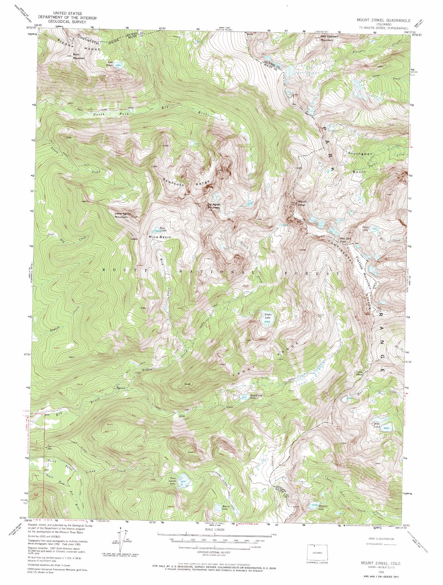
USGS Topo Quad 40106g6 - 1:24,000 scale
| Topo Map Name: | Mount Zirkel |
| USGS Topo Quad ID: | 40106g6 |
| Print Size: | ca. 21 1/4" wide x 27" high |
| Southeast Coordinates: | 40.75° N latitude / 106.625° W longitude |
| Map Center Coordinates: | 40.8125° N latitude / 106.6875° W longitude |
| U.S. State: | CO |
| Filename: | o40106g6.jpg |
| Download Map JPG Image: | Mount Zirkel topo map 1:24,000 scale |
| Map Type: | Topographic |
| Topo Series: | 7.5´ |
| Map Scale: | 1:24,000 |
| Source of Map Images: | United States Geological Survey (USGS) |
| Alternate Map Versions: |
Mount Zirkel CO 1955, updated 1957 Download PDF Buy paper map Mount Zirkel CO 1955, updated 1957 Download PDF Buy paper map Mount Zirkel CO 1955, updated 1962 Download PDF Buy paper map Mount Zirkel CO 1955, updated 1968 Download PDF Buy paper map Mount Zirkel CO 1955, updated 1984 Download PDF Buy paper map Mount Zirkel CO 1955, updated 1984 Download PDF Buy paper map Mount Zirkel CO 2000, updated 2004 Download PDF Buy paper map Mount Zirkel CO 2011 Download PDF Buy paper map Mount Zirkel CO 2013 Download PDF Buy paper map Mount Zirkel CO 2016 Download PDF Buy paper map |
| FStopo: | US Forest Service topo Mount Zirkel is available: Download FStopo PDF Download FStopo TIF |
1:24,000 Topo Quads surrounding Mount Zirkel
Solomon Creek |
Dudley Creek |
Blackhall Mountain |
Trent Creek |
Elkhorn Point |
Elkhorn Mountain |
West Fork Lake |
Davis Peak |
Pearl |
Independence Mountain |
Hahns Peak |
Farwell Mountain |
Mount Zirkel |
Boettcher Lake |
Lake John |
Clark |
Floyd Peak |
Mount Ethel |
Pitchpine Mountain |
Delaney Butte |
Mad Creek |
Rocky Peak |
Buffalo Pass |
Teal Lake |
Coalmont |
> Back to 40106e1 at 1:100,000 scale
> Back to 40106a1 at 1:250,000 scale
> Back to U.S. Topo Maps home
Mount Zirkel topo map: Gazetteer
Mount Zirkel: Basins
Fryingpan Basin elevation 3148m 10328′Mica Basin elevation 3185m 10449′
Mount Zirkel: Flats
Encampment Meadows elevation 2989m 9806′Mount Zirkel: Gaps
Ute Pass elevation 3347m 10980′Mount Zirkel: Lakes
Bear Lakes elevation 3159m 10364′Beaver Lake elevation 3196m 10485′
Bighorn Lake elevation 3082m 10111′
Gilpin Lake elevation 3153m 10344′
Gold Creek Lake elevation 2914m 9560′
Lake Diana elevation 3131m 10272′
Mica Lake elevation 3180m 10433′
Peggy Lake elevation 3410m 11187′
Three Island Lake elevation 3211m 10534′
Mount Zirkel: Mines
Lower Slavonia Mine elevation 2640m 8661′Slavonia Mine elevation 3268m 10721′
Upper Slavonia Mine elevation 3253m 10672′
Mount Zirkel: Populated Places
Slavonia elevation 2986m 9796′Mount Zirkel: Ranges
Sawtooth Range elevation 3471m 11387′Mount Zirkel: Streams
Gilpin Creek elevation 2570m 8431′Gold Creek elevation 2570m 8431′
Mica Creek elevation 2770m 9087′
Mount Zirkel: Summits
Big Agnes Mountain elevation 3506m 11502′Buck Mountain elevation 3468m 11377′
Flattop Mountain elevation 3581m 11748′
Little Agnes Mountain elevation 3505m 11499′
Little Agness Mountain elevation 3421m 11223′
Mount Zirkel elevation 3713m 12181′
Mount Zirkel: Swamps
Swamp Park elevation 3181m 10436′Mount Zirkel: Trails
Gilpin Trail elevation 2918m 9573′Lone Pine Trail elevation 2862m 9389′
Mica Basin Trail elevation 3085m 10121′
Red Dirt Pass Trail elevation 3393m 11131′
Three Island Lake Trail elevation 2911m 9550′
Mount Zirkel digital topo map on disk
Buy this Mount Zirkel topo map showing relief, roads, GPS coordinates and other geographical features, as a high-resolution digital map file on DVD: