West Fork Lake Topo Map Colorado
To zoom in, hover over the map of West Fork Lake
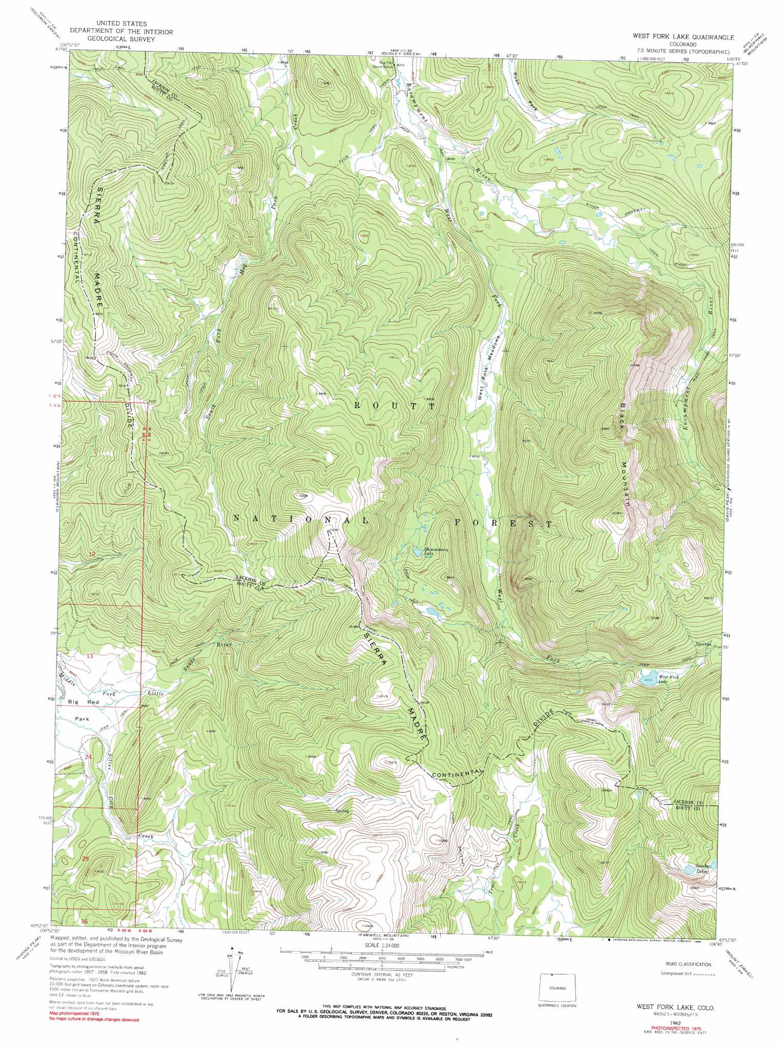
USGS Topo Quad 40106h7 - 1:24,000 scale
| Topo Map Name: | West Fork Lake |
| USGS Topo Quad ID: | 40106h7 |
| Print Size: | ca. 21 1/4" wide x 27" high |
| Southeast Coordinates: | 40.875° N latitude / 106.75° W longitude |
| Map Center Coordinates: | 40.9375° N latitude / 106.8125° W longitude |
| U.S. State: | CO |
| Filename: | o40106h7.jpg |
| Download Map JPG Image: | West Fork Lake topo map 1:24,000 scale |
| Map Type: | Topographic |
| Topo Series: | 7.5´ |
| Map Scale: | 1:24,000 |
| Source of Map Images: | United States Geological Survey (USGS) |
| Alternate Map Versions: |
West Fork Lake CO 1962, updated 1964 Download PDF Buy paper map West Fork Lake CO 1962, updated 1964 Download PDF Buy paper map West Fork Lake CO 1962, updated 1970 Download PDF Buy paper map West Fork Lake CO 1962, updated 1990 Download PDF Buy paper map West Fork Lake CO 2000, updated 2004 Download PDF Buy paper map West Fork Lake CO 2011 Download PDF Buy paper map West Fork Lake CO 2013 Download PDF Buy paper map West Fork Lake CO 2016 Download PDF Buy paper map |
| FStopo: | US Forest Service topo West Fork Lake is available: Download FStopo PDF Download FStopo TIF |
1:24,000 Topo Quads surrounding West Fork Lake
Bridger Peak |
Red Mountain |
Encampment |
Gunst Reservoir |
Barcus Peak |
Fletcher Peak |
Solomon Creek |
Dudley Creek |
Blackhall Mountain |
Trent Creek |
Shield Mountain |
Elkhorn Mountain |
West Fork Lake |
Davis Peak |
Pearl |
Meaden Peak |
Hahns Peak |
Farwell Mountain |
Mount Zirkel |
Boettcher Lake |
Pilot Knob |
Clark |
Floyd Peak |
Mount Ethel |
Pitchpine Mountain |
> Back to 40106e1 at 1:100,000 scale
> Back to 40106a1 at 1:250,000 scale
> Back to U.S. Topo Maps home
West Fork Lake topo map: Gazetteer
West Fork Lake: Dams
Lower Big Creek Dam elevation 3183m 10442′West Fork Lake: Flats
Ryan Park elevation 2630m 8628′West Fork Meadows elevation 2646m 8681′
West Fork Lake: Lakes
Manzanares Lake elevation 2812m 9225′Sanchez Lakes elevation 3240m 10629′
West Fork Lake elevation 2838m 9311′
West Fork Lake: Mines
Peak 9731 Mine elevation 2955m 9694′West Fork Lake: Reservoirs
Lower Big Creek Reservoir elevation 3183m 10442′West Fork Lake: Streams
West Fork Encampment River elevation 2565m 8415′West Fork Lake: Summits
Black Mountain elevation 3240m 10629′West Fork Lake: Trails
Ellis Trail elevation 2653m 8704′Fireline Trail elevation 3007m 9865′
West Fork Trail elevation 2809m 9215′
West Fork Lake digital topo map on disk
Buy this West Fork Lake topo map showing relief, roads, GPS coordinates and other geographical features, as a high-resolution digital map file on DVD: