Sawmill Mountain Topo Map Colorado
To zoom in, hover over the map of Sawmill Mountain
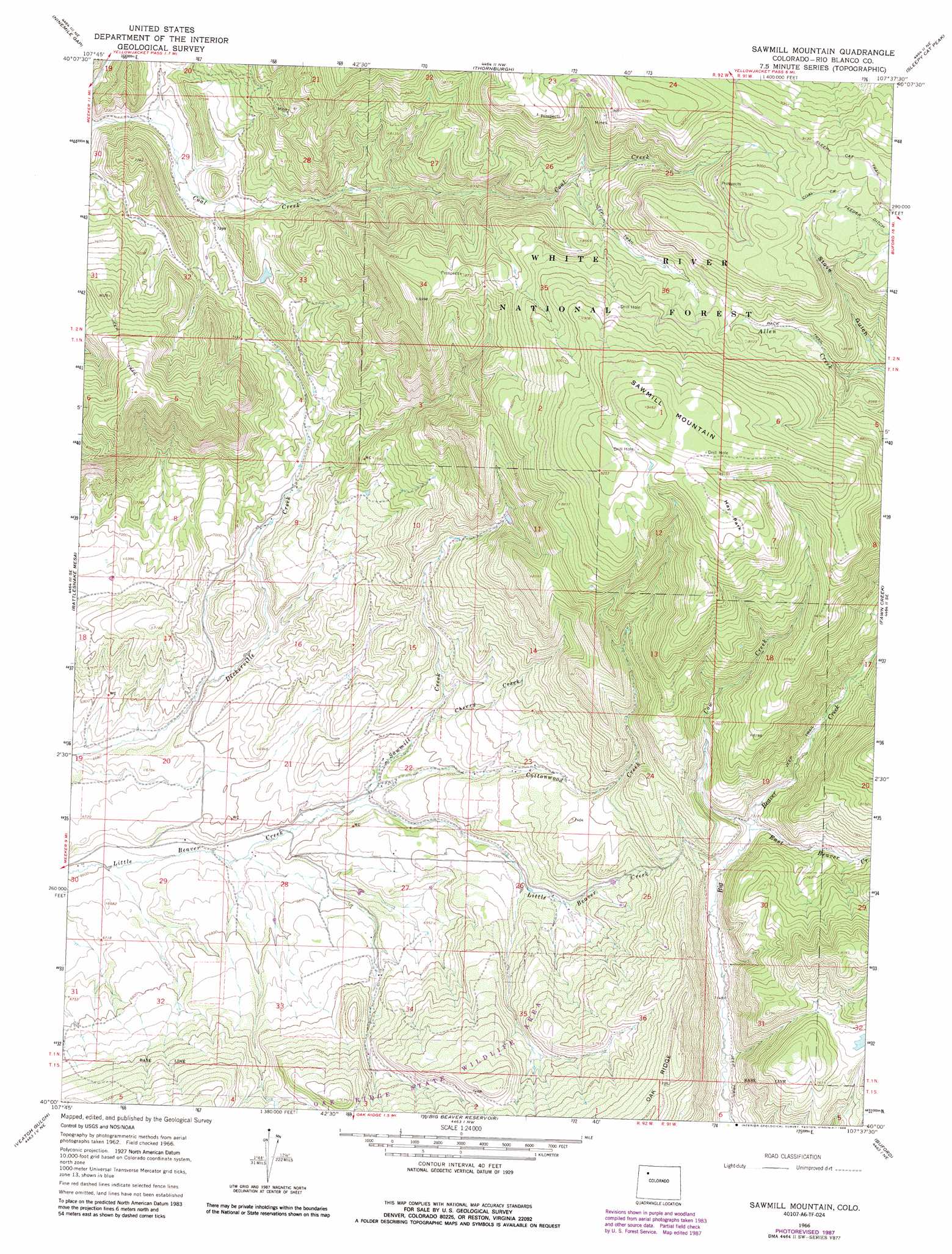
USGS Topo Quad 40107a6 - 1:24,000 scale
| Topo Map Name: | Sawmill Mountain |
| USGS Topo Quad ID: | 40107a6 |
| Print Size: | ca. 21 1/4" wide x 27" high |
| Southeast Coordinates: | 40° N latitude / 107.625° W longitude |
| Map Center Coordinates: | 40.0625° N latitude / 107.6875° W longitude |
| U.S. State: | CO |
| Filename: | o40107a6.jpg |
| Download Map JPG Image: | Sawmill Mountain topo map 1:24,000 scale |
| Map Type: | Topographic |
| Topo Series: | 7.5´ |
| Map Scale: | 1:24,000 |
| Source of Map Images: | United States Geological Survey (USGS) |
| Alternate Map Versions: |
Sawmill Mountain CO 1966, updated 1970 Download PDF Buy paper map Sawmill Mountain CO 1966, updated 1970 Download PDF Buy paper map Sawmill Mountain CO 1966, updated 1988 Download PDF Buy paper map Sawmill Mountain CO 2011 Download PDF Buy paper map Sawmill Mountain CO 2013 Download PDF Buy paper map Sawmill Mountain CO 2016 Download PDF Buy paper map |
| FStopo: | US Forest Service topo Sawmill Mountain is available: Download FStopo PDF Download FStopo TIF |
1:24,000 Topo Quads surrounding Sawmill Mountain
Easton Gulch |
Axial |
Monument Butte |
Hamilton |
Pagoda |
Devils Hole Gulch |
Ninemile Gap |
Thornburgh |
Sleepy Cat Peak |
Slide Creek |
Meeker |
Rattlesnake Mesa |
Sawmill Mountain |
Fawn Creek |
Lost Park |
Lo 7 Hill |
Veatch Gulch |
Big Beaver Reservoir |
Buford |
Oyster Lake |
Thirteenmile Creek |
Red Elephant Point |
Triangle Park |
Meadow Creek Lake |
Blair Mountain |
> Back to 40107a1 at 1:100,000 scale
> Back to 40106a1 at 1:250,000 scale
> Back to U.S. Topo Maps home
Sawmill Mountain topo map: Gazetteer
Sawmill Mountain: Dams
Big Lick Irrigation Dam elevation 2347m 7700′Sawmill Mountain: Flats
Hay Park elevation 2836m 9304′Sawmill Mountain: Mines
Coal Creek Number One Mine elevation 2715m 8907′Sawmill Mountain: Reservoirs
Big Lick Reservoir elevation 2347m 7700′Sawmill Mountain: Streams
Cherry Creek elevation 2133m 6998′Cottonwood Creek elevation 2088m 6850′
Cow Creek elevation 2227m 7306′
East Beaver Creek elevation 2225m 7299′
Sawmill Creek elevation 2070m 6791′
Sawmill Mountain: Summits
Sawmill Mountain elevation 2883m 9458′Sawmill Mountain digital topo map on disk
Buy this Sawmill Mountain topo map showing relief, roads, GPS coordinates and other geographical features, as a high-resolution digital map file on DVD: