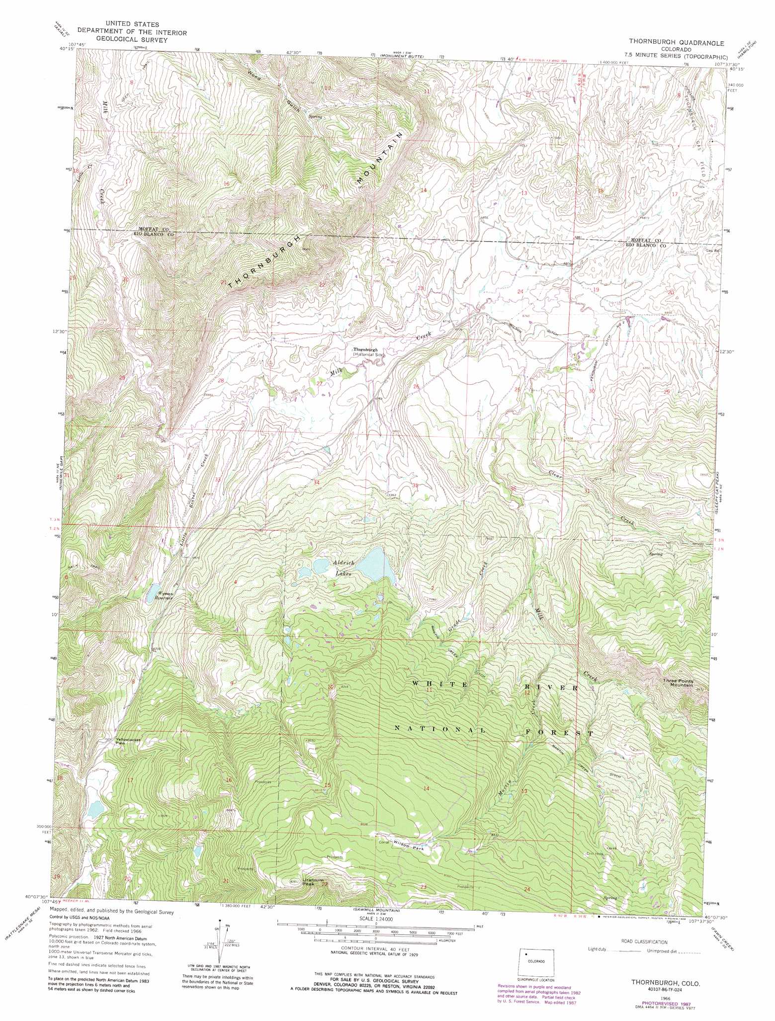
Thornburgh Topo Map Colorado
To zoom in, hover over the map of Thornburgh
USGS Topo Quad 40107b6 - 1:24,000 scale
| Topo Map Name: | Thornburgh |
| USGS Topo Quad ID: | 40107b6 |
| Print Size: | ca. 21 1/4" wide x 27" high |
| Southeast Coordinates: | 40.125° N latitude / 107.625° W longitude |
| Map Center Coordinates: | 40.1875° N latitude / 107.6875° W longitude |
| U.S. State: | CO |
| Filename: | o40107b6.jpg |
| Download Map JPG Image: | Thornburgh topo map 1:24,000 scale |
| Map Type: | Topographic |
| Topo Series: | 7.5´ |
| Map Scale: | 1:24,000 |
| Source of Map Images: | United States Geological Survey (USGS) |
| Alternate Map Versions: |
Thornburgh CO 1966, updated 1969 Download PDF Buy paper map Thornburgh CO 1966, updated 1969 Download PDF Buy paper map Thornburgh CO 1966, updated 1970 Download PDF Buy paper map Thornburgh CO 1966, updated 1988 Download PDF Buy paper map Thornburgh CO 1966, updated 1988 Download PDF Buy paper map Thornburgh CO 1966, updated 1988 Download PDF Buy paper map Thornburgh CO 2011 Download PDF Buy paper map Thornburgh CO 2013 Download PDF Buy paper map Thornburgh CO 2016 Download PDF Buy paper map |
| FStopo: | US Forest Service topo Thornburgh is available: Download FStopo PDF Download FStopo TIF |
1:24,000 Topo Quads surrounding Thornburgh
Juniper Hot Springs |
Horse Gulch |
Round Bottom |
Castor Gulch |
Breeze Mountain |
Easton Gulch |
Axial |
Monument Butte |
Hamilton |
Pagoda |
Devils Hole Gulch |
Ninemile Gap |
Thornburgh |
Sleepy Cat Peak |
Slide Creek |
Meeker |
Rattlesnake Mesa |
Sawmill Mountain |
Fawn Creek |
Lost Park |
Lo 7 Hill |
Veatch Gulch |
Big Beaver Reservoir |
Buford |
Oyster Lake |
> Back to 40107a1 at 1:100,000 scale
> Back to 40106a1 at 1:250,000 scale
> Back to U.S. Topo Maps home
Thornburgh topo map: Gazetteer
Thornburgh: Canals
Ferguson Ditch Number 2 elevation 2078m 6817′Martin Creek Ditch elevation 2356m 7729′
Wilson Ditch elevation 2073m 6801′
Thornburgh: Dams
D D and E Wise Dam elevation 2265m 7431′Wyman Dam elevation 2153m 7063′
Thornburgh: Flats
Wilson Park elevation 2732m 8963′Thornburgh: Lakes
Aldrich Lakes elevation 2290m 7513′Thornburgh: Mines
Butterfly Mine elevation 2759m 9051′Windy Point Number One Mine elevation 2798m 9179′
Thornburgh: Oilfields
Thornburgh Gas Field elevation 2104m 6902′Thornburgh: Populated Places
Thornburgh elevation 2054m 6738′Thornburgh: Reservoirs
D D and E Wise Reservoir elevation 2265m 7431′Wyman Reservoir elevation 2153m 7063′
Thornburgh: Streams
Clear Creek elevation 2088m 6850′Grade Creek elevation 2140m 7020′
Little Beaver Creek elevation 2017m 6617′
Little Creek elevation 1969m 6459′
Martin Creek elevation 2207m 7240′
Thornburgh: Summits
Thornburgh Mountain elevation 2463m 8080′Three Points Mountain elevation 2626m 8615′
Uranium Peak elevation 2846m 9337′
Thornburgh: Trails
Yellowjacket Pass Stock Driveway elevation 2695m 8841′Thornburgh digital topo map on disk
Buy this Thornburgh topo map showing relief, roads, GPS coordinates and other geographical features, as a high-resolution digital map file on DVD: