Quaker Mountain Topo Map Colorado
To zoom in, hover over the map of Quaker Mountain
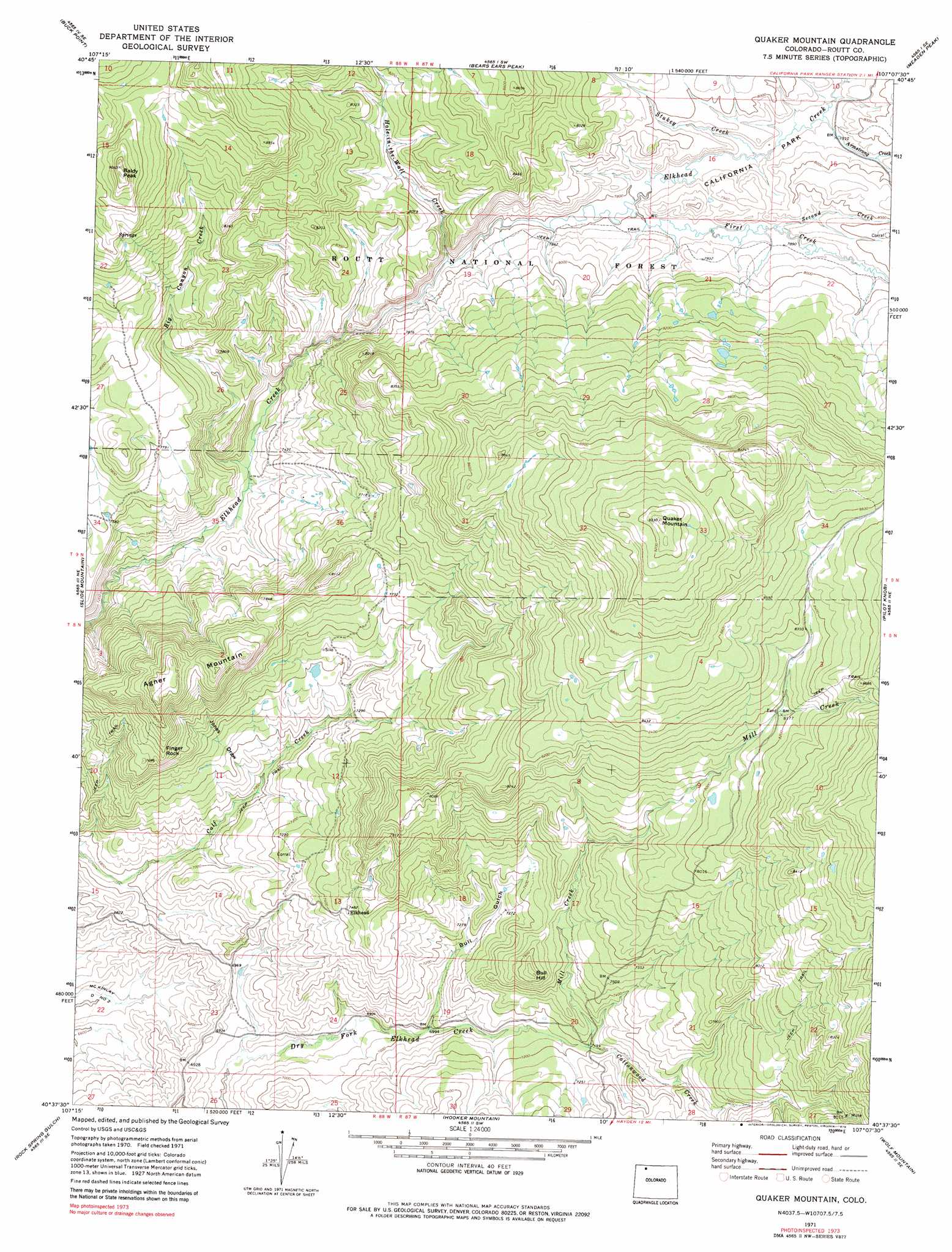
USGS Topo Quad 40107f2 - 1:24,000 scale
| Topo Map Name: | Quaker Mountain |
| USGS Topo Quad ID: | 40107f2 |
| Print Size: | ca. 21 1/4" wide x 27" high |
| Southeast Coordinates: | 40.625° N latitude / 107.125° W longitude |
| Map Center Coordinates: | 40.6875° N latitude / 107.1875° W longitude |
| U.S. State: | CO |
| Filename: | o40107f2.jpg |
| Download Map JPG Image: | Quaker Mountain topo map 1:24,000 scale |
| Map Type: | Topographic |
| Topo Series: | 7.5´ |
| Map Scale: | 1:24,000 |
| Source of Map Images: | United States Geological Survey (USGS) |
| Alternate Map Versions: |
Quaker Mountain CO 1971, updated 1974 Download PDF Buy paper map Quaker Mountain CO 1971, updated 1974 Download PDF Buy paper map Quaker Mountain CO 1971, updated 1979 Download PDF Buy paper map Quaker Mountain CO 1971, updated 1979 Download PDF Buy paper map Quaker Mountain CO 2000, updated 2004 Download PDF Buy paper map Quaker Mountain CO 2011 Download PDF Buy paper map Quaker Mountain CO 2013 Download PDF Buy paper map Quaker Mountain CO 2016 Download PDF Buy paper map |
| FStopo: | US Forest Service topo Quaker Mountain is available: Download FStopo PDF Download FStopo TIF |
1:24,000 Topo Quads surrounding Quaker Mountain
Bakers Peak |
Fly Creek |
Tumble Mountain |
Shield Mountain |
Elkhorn Mountain |
Freeman Reservoir |
Buck Point |
Bears Ears Peaks |
Meaden Peak |
Hahns Peak |
Mcinturf Mesa |
Slide Mountain |
Quaker Mountain |
Pilot Knob |
Clark |
Ralph White Lake |
Rock Spring Gulch |
Hooker Mountain |
Wolf Mountain |
Mad Creek |
Breeze Mountain |
Hayden |
Mount Harris |
Milner |
Cow Creek |
> Back to 40107e1 at 1:100,000 scale
> Back to 40106a1 at 1:250,000 scale
> Back to U.S. Topo Maps home
Quaker Mountain topo map: Gazetteer
Quaker Mountain: Cliffs
Finger Rock elevation 2380m 7808′Quaker Mountain: Populated Places
Elkhead elevation 2282m 7486′Quaker Mountain: Streams
Armstrong Creek elevation 2400m 7874′Big Canyon Creek elevation 2222m 7290′
First Creek elevation 2403m 7883′
Hole-in-the-Wall Creek elevation 2384m 7821′
Mill Creek elevation 2190m 7185′
Second Creek elevation 2400m 7874′
Stukey Creek elevation 2391m 7844′
Quaker Mountain: Summits
Agner Mountain elevation 2525m 8284′Baldy Peak elevation 2743m 8999′
Bull Hill elevation 2355m 7726′
Quaker Mountain elevation 2844m 9330′
Quaker Mountain: Valleys
Bull Gulch elevation 2127m 6978′Jones Draw elevation 2134m 7001′
Quaker Mountain digital topo map on disk
Buy this Quaker Mountain topo map showing relief, roads, GPS coordinates and other geographical features, as a high-resolution digital map file on DVD: