Jack Springs Topo Map Colorado
To zoom in, hover over the map of Jack Springs
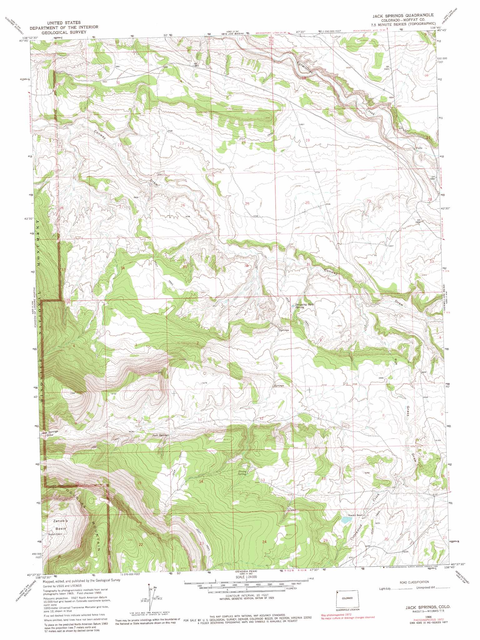
USGS Topo Quad 40108f7 - 1:24,000 scale
| Topo Map Name: | Jack Springs |
| USGS Topo Quad ID: | 40108f7 |
| Print Size: | ca. 21 1/4" wide x 27" high |
| Southeast Coordinates: | 40.625° N latitude / 108.75° W longitude |
| Map Center Coordinates: | 40.6875° N latitude / 108.8125° W longitude |
| U.S. State: | CO |
| Filename: | o40108f7.jpg |
| Download Map JPG Image: | Jack Springs topo map 1:24,000 scale |
| Map Type: | Topographic |
| Topo Series: | 7.5´ |
| Map Scale: | 1:24,000 |
| Source of Map Images: | United States Geological Survey (USGS) |
| Alternate Map Versions: |
Jack Springs CO 1966, updated 1970 Download PDF Buy paper map Jack Springs CO 1966, updated 1970 Download PDF Buy paper map Jack Springs CO 1966, updated 1980 Download PDF Buy paper map Jack Springs CO 2010 Download PDF Buy paper map Jack Springs CO 2013 Download PDF Buy paper map Jack Springs CO 2016 Download PDF Buy paper map |
1:24,000 Topo Quads surrounding Jack Springs
Willow Creek Butte |
Beaver Basin |
Sparks |
Sugarloaf Butte |
Hiawatha |
Swallow Canyon |
Lodore School |
Big Joe Basin |
Irish Canyon |
G Spring |
Hoy Mountain |
Canyon Of Lodore North |
Jack Springs |
Vermillion Mesa |
Sheephead Basin |
Jones Hole |
Canyon Of Lodore South |
Zenobia Peak |
Greystone |
Limestone Hill |
Stuntz Reservoir |
Hells Canyon |
Tanks Peak |
Haystack Rock |
Indian Water Canyon |
> Back to 40108e1 at 1:100,000 scale
> Back to 40108a1 at 1:250,000 scale
> Back to U.S. Topo Maps home
Jack Springs topo map: Gazetteer
Jack Springs: Springs
Dripping Rock Spring elevation 1755m 5757′Jack Springs elevation 1967m 6453′
Jack Springs: Streams
Cottonwood Creek elevation 1854m 6082′Jack Springs: Summits
Douglas Mountain elevation 2637m 8651′Jack Springs: Valleys
Douglas Draw elevation 1715m 5626′Rye Grass Draw elevation 1730m 5675′
Jack Springs digital topo map on disk
Buy this Jack Springs topo map showing relief, roads, GPS coordinates and other geographical features, as a high-resolution digital map file on DVD: