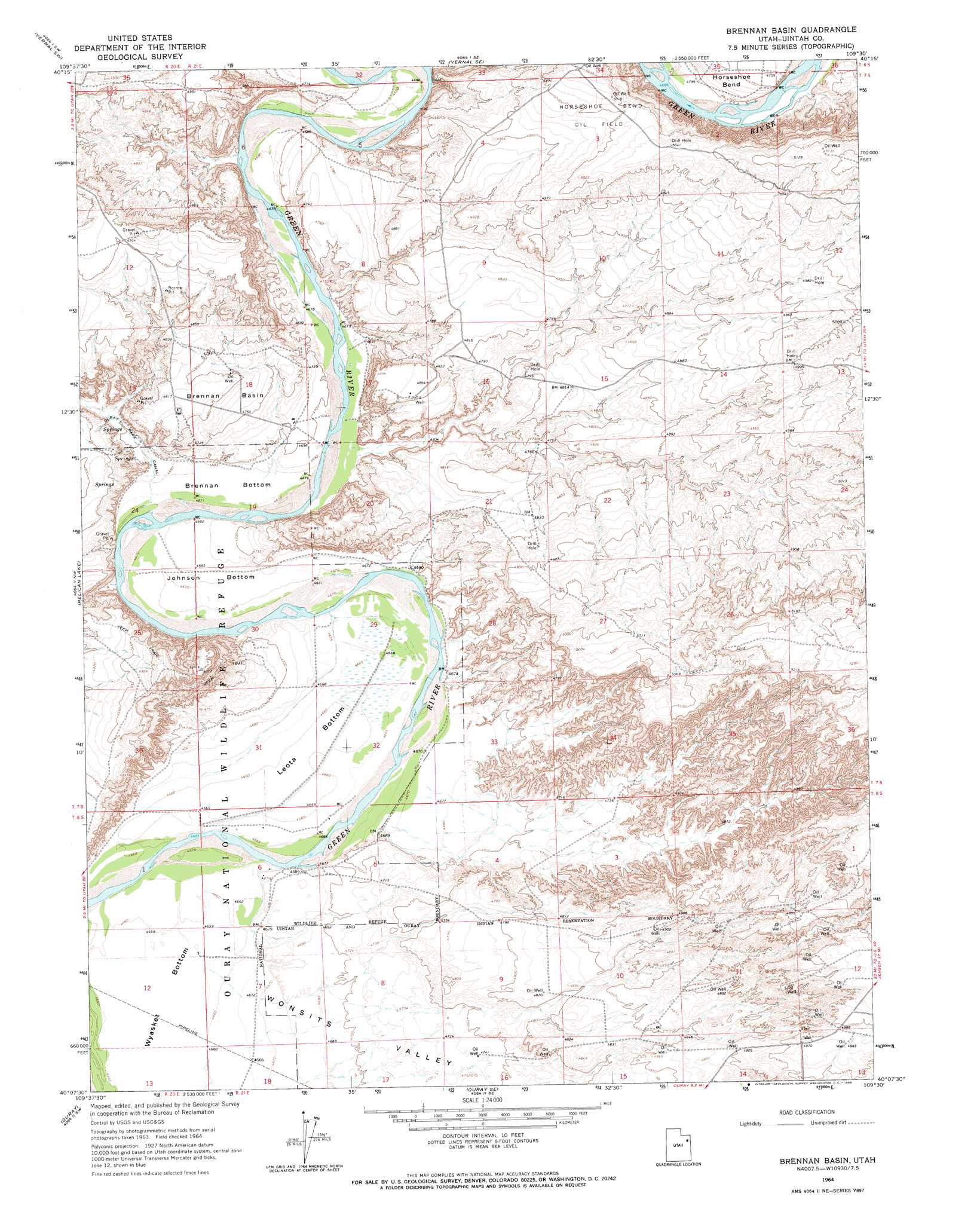
Brennan Basin Topo Map Utah
To zoom in, hover over the map of Brennan Basin
USGS Topo Quad 40109b5 - 1:24,000 scale
| Topo Map Name: | Brennan Basin |
| USGS Topo Quad ID: | 40109b5 |
| Print Size: | ca. 21 1/4" wide x 27" high |
| Southeast Coordinates: | 40.125° N latitude / 109.5° W longitude |
| Map Center Coordinates: | 40.1875° N latitude / 109.5625° W longitude |
| U.S. State: | UT |
| Filename: | o40109b5.jpg |
| Download Map JPG Image: | Brennan Basin topo map 1:24,000 scale |
| Map Type: | Topographic |
| Topo Series: | 7.5´ |
| Map Scale: | 1:24,000 |
| Source of Map Images: | United States Geological Survey (USGS) |
| Alternate Map Versions: |
Brennan Basin UT 1964, updated 1966 Download PDF Buy paper map Brennan Basin UT 1964, updated 1966 Download PDF Buy paper map Brennan Basin UT 2011 Download PDF Buy paper map Brennan Basin UT 2014 Download PDF Buy paper map |
1:24,000 Topo Quads surrounding Brennan Basin
Lapoint |
Vernal Nw |
Vernal Ne |
Naples |
Dinosaur Quarry |
Fort Duchesne |
Vernal Sw |
Vernal Se |
Rasmussen Hollow |
Jensen |
Randlett |
Pelican Lake |
Brennan Basin |
Red Wash Nw |
Red Wash |
Uteland Butte |
Ouray |
Ouray Se |
Red Wash Sw |
Red Wash Se |
Moon Bottom |
Big Pack Mountain Nw |
Big Pack Mountain Ne |
Archy Bench |
Asphalt Wash |
> Back to 40109a1 at 1:100,000 scale
> Back to 40108a1 at 1:250,000 scale
> Back to U.S. Topo Maps home
Brennan Basin topo map: Gazetteer
Brennan Basin: Basins
Brennan Basin elevation 1461m 4793′Uinta Basin elevation 1483m 4865′
Brennan Basin: Bends
Brennan Bottom elevation 1427m 4681′Johnson Bottom elevation 1428m 4685′
Leota Bottom elevation 1424m 4671′
Wyasket Bottom elevation 1420m 4658′
Brennan Basin: Oilfields
Horseshoe Bend Oil Field elevation 1524m 5000′Brennan Basin: Valleys
Wonsits Valley elevation 1421m 4662′Brennan Basin digital topo map on disk
Buy this Brennan Basin topo map showing relief, roads, GPS coordinates and other geographical features, as a high-resolution digital map file on DVD: