Dutch John Topo Map Utah
To zoom in, hover over the map of Dutch John
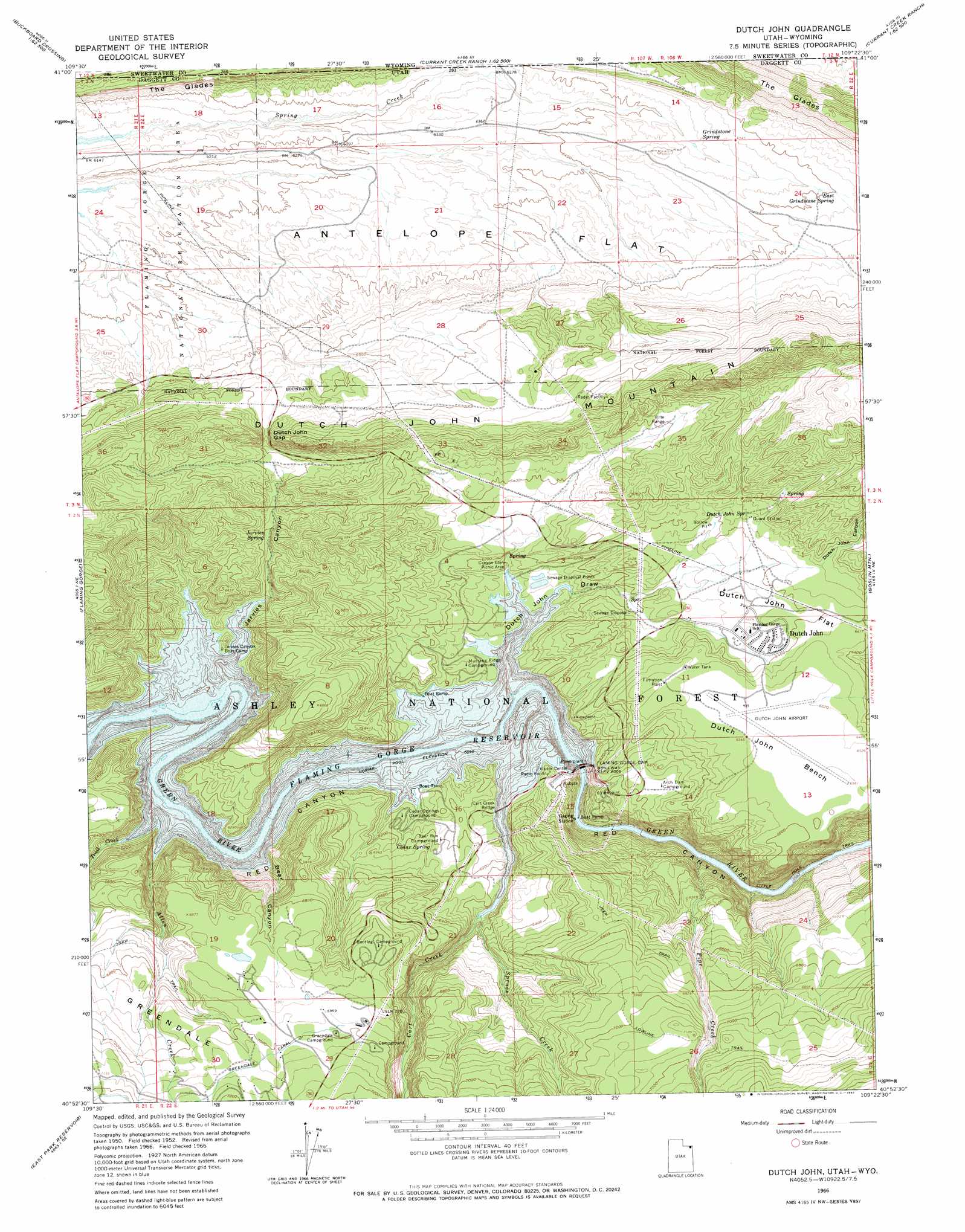
USGS Topo Quad 40109h4 - 1:24,000 scale
| Topo Map Name: | Dutch John |
| USGS Topo Quad ID: | 40109h4 |
| Print Size: | ca. 21 1/4" wide x 27" high |
| Southeast Coordinates: | 40.875° N latitude / 109.375° W longitude |
| Map Center Coordinates: | 40.9375° N latitude / 109.4375° W longitude |
| U.S. States: | UT, WY |
| Filename: | o40109h4.jpg |
| Download Map JPG Image: | Dutch John topo map 1:24,000 scale |
| Map Type: | Topographic |
| Topo Series: | 7.5´ |
| Map Scale: | 1:24,000 |
| Source of Map Images: | United States Geological Survey (USGS) |
| Alternate Map Versions: |
Dutch John Mtn UT 1952, updated 1954 Download PDF Buy paper map Dutch John Mtn UT 1952, updated 1959 Download PDF Buy paper map Dutch John UT 1966, updated 1967 Download PDF Buy paper map Dutch John UT 1996, updated 1999 Download PDF Buy paper map Dutch John UT 2011 Download PDF Buy paper map Dutch John UT 2014 Download PDF Buy paper map |
| FStopo: | US Forest Service topo Dutch John is available: Download FStopo PDF Download FStopo TIF |
1:24,000 Topo Quads surrounding Dutch John
Devils Playground |
Haystack Buttes North |
Sugarloaf Basin |
Big Ridge |
Maxon Ranch |
Linwood Canyon |
Haystack Buttes South |
Minnies Gap |
Hawks Nest |
Richards Gap |
Manila |
Flaming Gorge |
Dutch John |
Goslin Mountain |
Clay Basin |
Elk Park |
East Park Reservoir |
Mount Lena |
Jackson Draw |
Warren Draw |
Taylor Mountain |
Dyer Mountain |
Burnt Cabin Gorge |
Blair Basin |
Crouse Reservoir |
> Back to 40109e1 at 1:100,000 scale
> Back to 40108a1 at 1:250,000 scale
> Back to U.S. Topo Maps home
Dutch John topo map: Gazetteer
Dutch John: Airports
Dutch John Airport elevation 2000m 6561′Dutch John Helibase elevation 1974m 6476′
Dutch John: Areas
Greendale elevation 2096m 6876′Dutch John: Benches
Dutch John Bench elevation 2000m 6561′Dutch John: Bridges
Cart Creek Bridge elevation 1842m 6043′Dutch John: Capes
Gold Point elevation 1978m 6489′Dutch John: Cliffs
Blacktail Cliff elevation 1936m 6351′Dutch John: Dams
Flaming Gorge Dam elevation 1720m 5643′Dutch John: Flats
Alabama Flat elevation 1963m 6440′Antelope Flat elevation 1936m 6351′
Dutch John Flat elevation 1944m 6377′
Dutch John: Gaps
Dutch John Gap elevation 1996m 6548′Dutch John: Parks
Sweet Ranch National Historic Site elevation 2148m 7047′Dutch John: Populated Places
Dutch John elevation 1942m 6371′Flaming Gorge Lodge elevation 2122m 6961′
Flaming Gorge Summer Home Area elevation 2102m 6896′
Dutch John: Reservoirs
Flaming Gorge Reservoir elevation 1720m 5643′Dutch John: Ridges
Gold Point elevation 1842m 6043′Dutch John: Springs
Cedar Spring elevation 1894m 6213′Dutch John Spring elevation 1970m 6463′
East Grindstone Spring elevation 2013m 6604′
Grindstone Spring elevation 1976m 6482′
Jarvies Spring elevation 1889m 6197′
Dutch John: Streams
Allen Creek elevation 1842m 6043′Cart Creek elevation 1842m 6043′
Pipe Creek elevation 1703m 5587′
Spruce Creek elevation 1842m 6043′
Trail Creek elevation 1842m 6043′
Dutch John: Summits
Dutch John Mountain elevation 2307m 7568′Dutch John: Trails
Little Hole Trail elevation 1710m 5610′Lowline Trail elevation 2182m 7158′
Dutch John: Valleys
Bear Canyon elevation 1842m 6043′Dutch John Canyon elevation 1976m 6482′
Dutch John Draw elevation 1842m 6043′
Grindstone Wash elevation 1911m 6269′
Jarvies Canyon elevation 1842m 6043′
Dutch John: Woods
The Glades elevation 1946m 6384′Dutch John digital topo map on disk
Buy this Dutch John topo map showing relief, roads, GPS coordinates and other geographical features, as a high-resolution digital map file on DVD: