Strawberry Peak Topo Map Utah
To zoom in, hover over the map of Strawberry Peak
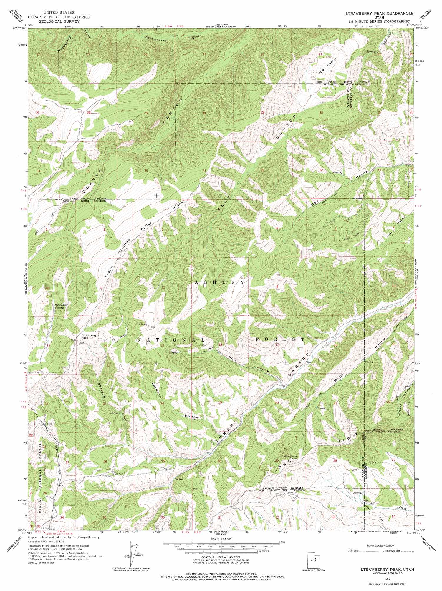
USGS Topo Quad 40110a8 - 1:24,000 scale
| Topo Map Name: | Strawberry Peak |
| USGS Topo Quad ID: | 40110a8 |
| Print Size: | ca. 21 1/4" wide x 27" high |
| Southeast Coordinates: | 40° N latitude / 110.875° W longitude |
| Map Center Coordinates: | 40.0625° N latitude / 110.9375° W longitude |
| U.S. State: | UT |
| Filename: | o40110a8.jpg |
| Download Map JPG Image: | Strawberry Peak topo map 1:24,000 scale |
| Map Type: | Topographic |
| Topo Series: | 7.5´ |
| Map Scale: | 1:24,000 |
| Source of Map Images: | United States Geological Survey (USGS) |
| Alternate Map Versions: |
Strawberry Peak UT 1962, updated 1964 Download PDF Buy paper map Strawberry Peak UT 1996, updated 2000 Download PDF Buy paper map Strawberry Peak UT 2011 Download PDF Buy paper map Strawberry Peak UT 2014 Download PDF Buy paper map |
| FStopo: | US Forest Service topo Strawberry Peak is available: Download FStopo PDF Download FStopo TIF |
1:24,000 Topo Quads surrounding Strawberry Peak
Co-Op Creek |
Jimmies Point |
Raspberry Knoll |
Tabby Mountain |
Tabiona |
Strawberry Reservoir Nw |
Strawberry Reservoir Ne |
Deep Creek Canyon |
Fruitland |
Strawberry Pinnacles |
Strawberry Reservoir Sw |
Strawberry Reservoir Se |
Strawberry Peak |
Avintaquin Canyon |
Sams Canyon |
Tucker |
Soldier Summit |
Flat Ridge |
Gray Head Peak |
Jones Hollow |
Scofield Reservoir |
Colton |
Kyune |
Matts Summit |
Minnie Maud Creek West |
> Back to 40110a1 at 1:100,000 scale
> Back to 40110a1 at 1:250,000 scale
> Back to U.S. Topo Maps home
Strawberry Peak topo map: Gazetteer
Strawberry Peak: Ridges
Twelve Hundred Dollar Ridge elevation 2959m 9708′Strawberry Peak: Springs
Big Beaver Springs elevation 2854m 9363′Strawberry Peak: Summits
Strawberry North Summit elevation 3117m 10226′Strawberry Peak elevation 3125m 10252′
The Knolls elevation 2466m 8090′
Strawberry Peak: Valleys
Jackson Hollow elevation 2398m 7867′Pine Hollow elevation 2355m 7726′
Shotgun Draw elevation 2503m 8211′
Water Hollow elevation 2233m 7326′
Strawberry Peak digital topo map on disk
Buy this Strawberry Peak topo map showing relief, roads, GPS coordinates and other geographical features, as a high-resolution digital map file on DVD: