Hancock Cove Topo Map Utah
To zoom in, hover over the map of Hancock Cove
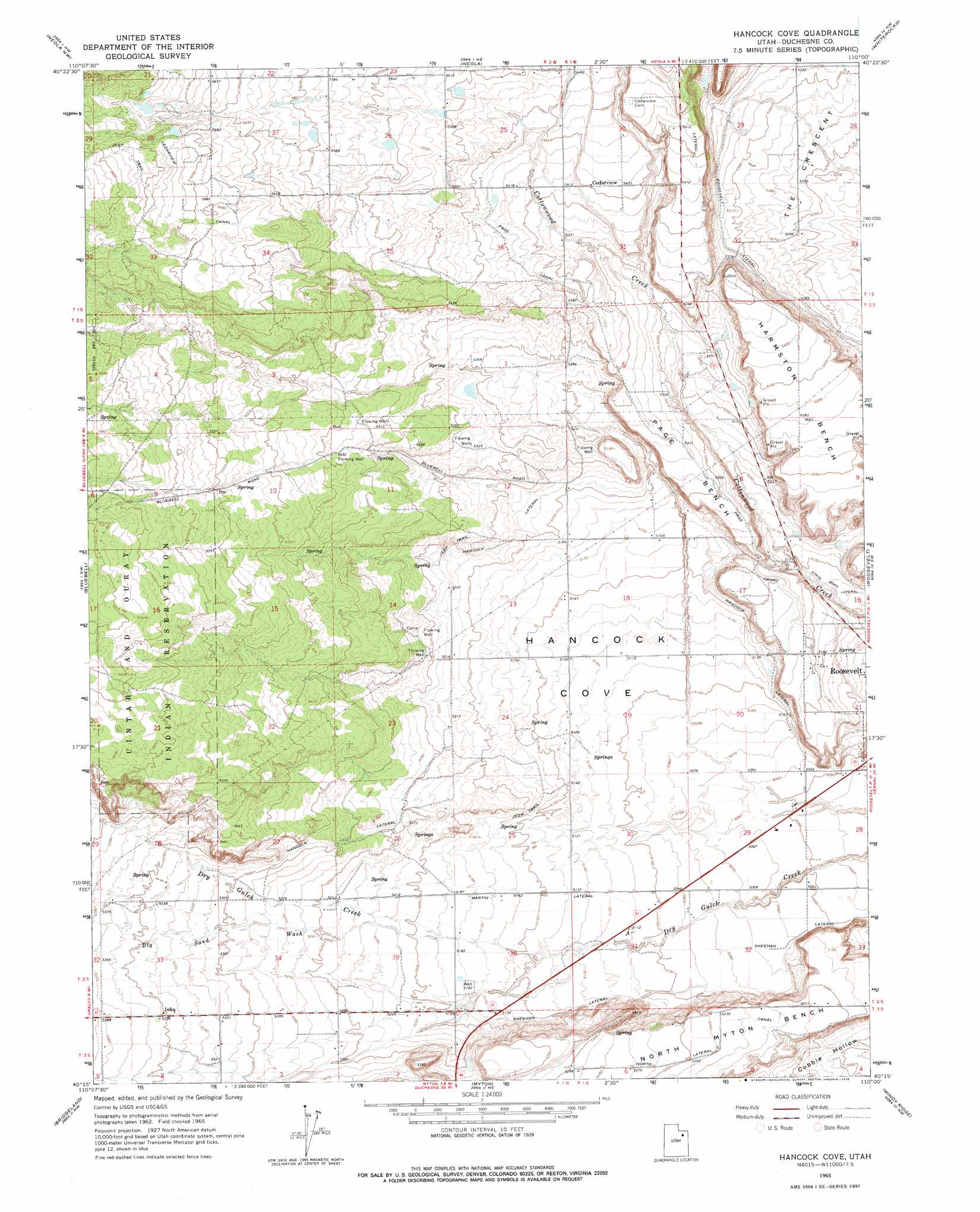
USGS Topo Quad 40110c1 - 1:24,000 scale
| Topo Map Name: | Hancock Cove |
| USGS Topo Quad ID: | 40110c1 |
| Print Size: | ca. 21 1/4" wide x 27" high |
| Southeast Coordinates: | 40.25° N latitude / 110° W longitude |
| Map Center Coordinates: | 40.3125° N latitude / 110.0625° W longitude |
| U.S. State: | UT |
| Filename: | o40110c1.jpg |
| Download Map JPG Image: | Hancock Cove topo map 1:24,000 scale |
| Map Type: | Topographic |
| Topo Series: | 7.5´ |
| Map Scale: | 1:24,000 |
| Source of Map Images: | United States Geological Survey (USGS) |
| Alternate Map Versions: |
Hancock Cove UT 1965, updated 1967 Download PDF Buy paper map Hancock Cove UT 1965, updated 1978 Download PDF Buy paper map Hancock Cove UT 2011 Download PDF Buy paper map Hancock Cove UT 2014 Download PDF Buy paper map |
1:24,000 Topo Quads surrounding Hancock Cove
Burnt Mill Spring |
Heller Lake |
Pole Creek Cave |
Ice Cave Peak |
Lake Mountain |
Altonah |
Neola Nw |
Neola |
Whiterocks |
Lapoint |
Altamont |
Bluebell |
Hancock Cove |
Roosevelt |
Fort Duchesne |
Duchesne Ne |
Bridgeland |
Myton |
Windy Ridge |
Randlett |
Duchesne Se |
Myton Sw |
Myton Se |
Pariette Draw Sw |
Uteland Butte |
> Back to 40110a1 at 1:100,000 scale
> Back to 40110a1 at 1:250,000 scale
> Back to U.S. Topo Maps home
Hancock Cove topo map: Gazetteer
Hancock Cove: Airports
Duchesne County Hospital Heliport elevation 1560m 5118′Roosevelt Municipal Airport elevation 1568m 5144′
Hancock Cove: Areas
Hancock Cove elevation 1561m 5121′Hancock Cove: Basins
The Crescent elevation 1602m 5255′Hancock Cove: Benches
Harmston Bench elevation 1644m 5393′Page Bench elevation 1621m 5318′
Hancock Cove: Canals
Hancock Lateral elevation 1586m 5203′Martin Lateral elevation 1572m 5157′
Page Canal elevation 1630m 5347′
Roosevelt Lateral elevation 1617m 5305′
Sheehan Lateral elevation 1553m 5095′
Hancock Cove: Populated Places
Cedarview elevation 1664m 5459′Ioka elevation 1631m 5351′
Hancock Cove: Valleys
Big Sand Wash elevation 1580m 5183′Hancock Cove digital topo map on disk
Buy this Hancock Cove topo map showing relief, roads, GPS coordinates and other geographical features, as a high-resolution digital map file on DVD: