Neola Nw Topo Map Utah
To zoom in, hover over the map of Neola Nw
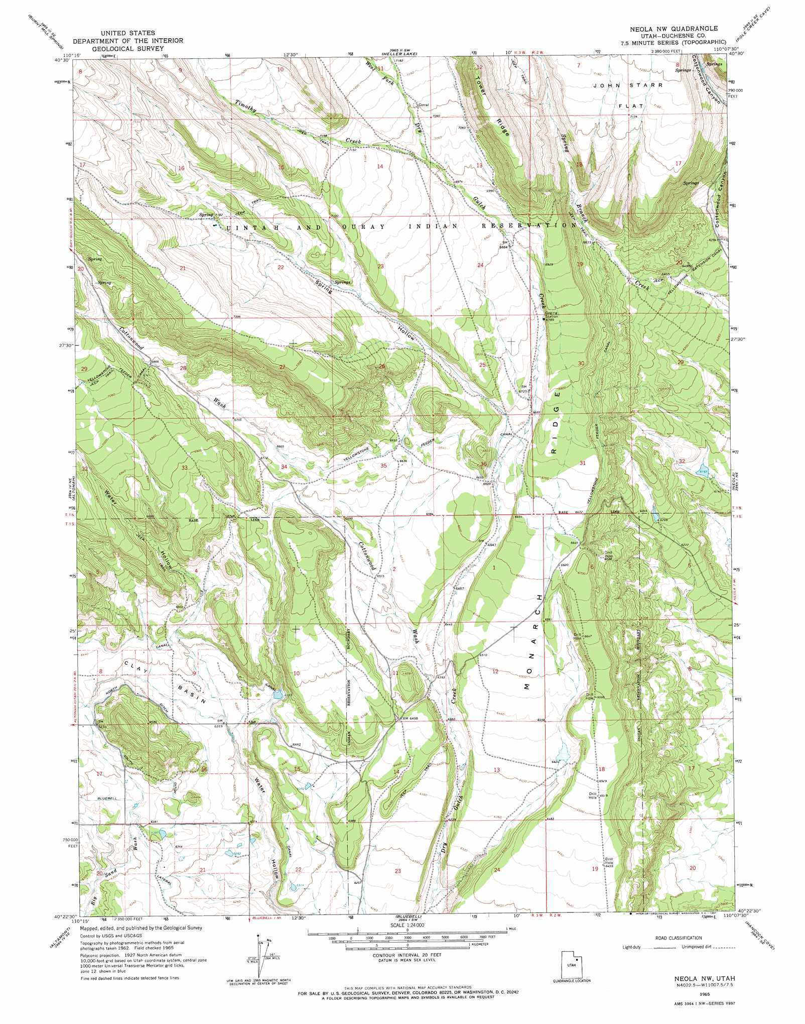
USGS Topo Quad 40110d2 - 1:24,000 scale
| Topo Map Name: | Neola Nw |
| USGS Topo Quad ID: | 40110d2 |
| Print Size: | ca. 21 1/4" wide x 27" high |
| Southeast Coordinates: | 40.375° N latitude / 110.125° W longitude |
| Map Center Coordinates: | 40.4375° N latitude / 110.1875° W longitude |
| U.S. State: | UT |
| Filename: | o40110d2.jpg |
| Download Map JPG Image: | Neola Nw topo map 1:24,000 scale |
| Map Type: | Topographic |
| Topo Series: | 7.5´ |
| Map Scale: | 1:24,000 |
| Source of Map Images: | United States Geological Survey (USGS) |
| Alternate Map Versions: |
Neola NW UT 1965, updated 1967 Download PDF Buy paper map Neola NW UT 2010 Download PDF Buy paper map Neola NW UT 2014 Download PDF Buy paper map |
1:24,000 Topo Quads surrounding Neola Nw
Garfield Basin |
Mount Emmons |
Bollie Lake |
Rasmussen Lakes |
Paradise Park |
Lake Fork Mountain |
Burnt Mill Spring |
Heller Lake |
Pole Creek Cave |
Ice Cave Peak |
Mountain Home |
Altonah |
Neola Nw |
Neola |
Whiterocks |
Talmage |
Altamont |
Bluebell |
Hancock Cove |
Roosevelt |
Duchesne |
Duchesne Ne |
Bridgeland |
Myton |
Windy Ridge |
> Back to 40110a1 at 1:100,000 scale
> Back to 40110a1 at 1:250,000 scale
> Back to U.S. Topo Maps home
Neola Nw topo map: Gazetteer
Neola Nw: Basins
Clay Basin elevation 1954m 6410′Neola Nw: Canals
F Canal elevation 1948m 6391′North Ditch elevation 1947m 6387′
South Ditch elevation 1964m 6443′
Yellowstone Extension Canal elevation 1954m 6410′
Yellowstone Feeder Canal elevation 2026m 6646′
Neola Nw: Dams
Cedarview Dam elevation 2200m 7217′Neola Nw: Ridges
Monarch Ridge elevation 2023m 6637′Neola Nw: Streams
Timothy Creek elevation 2139m 7017′West Fork Dry Gulch Creek elevation 2178m 7145′
Neola Nw: Valleys
Cottonwood Canyon elevation 1949m 6394′Cottonwood Wash elevation 1934m 6345′
Spring Hollow elevation 2041m 6696′
Neola Nw digital topo map on disk
Buy this Neola Nw topo map showing relief, roads, GPS coordinates and other geographical features, as a high-resolution digital map file on DVD: