Dry Mountain Topo Map Utah
To zoom in, hover over the map of Dry Mountain
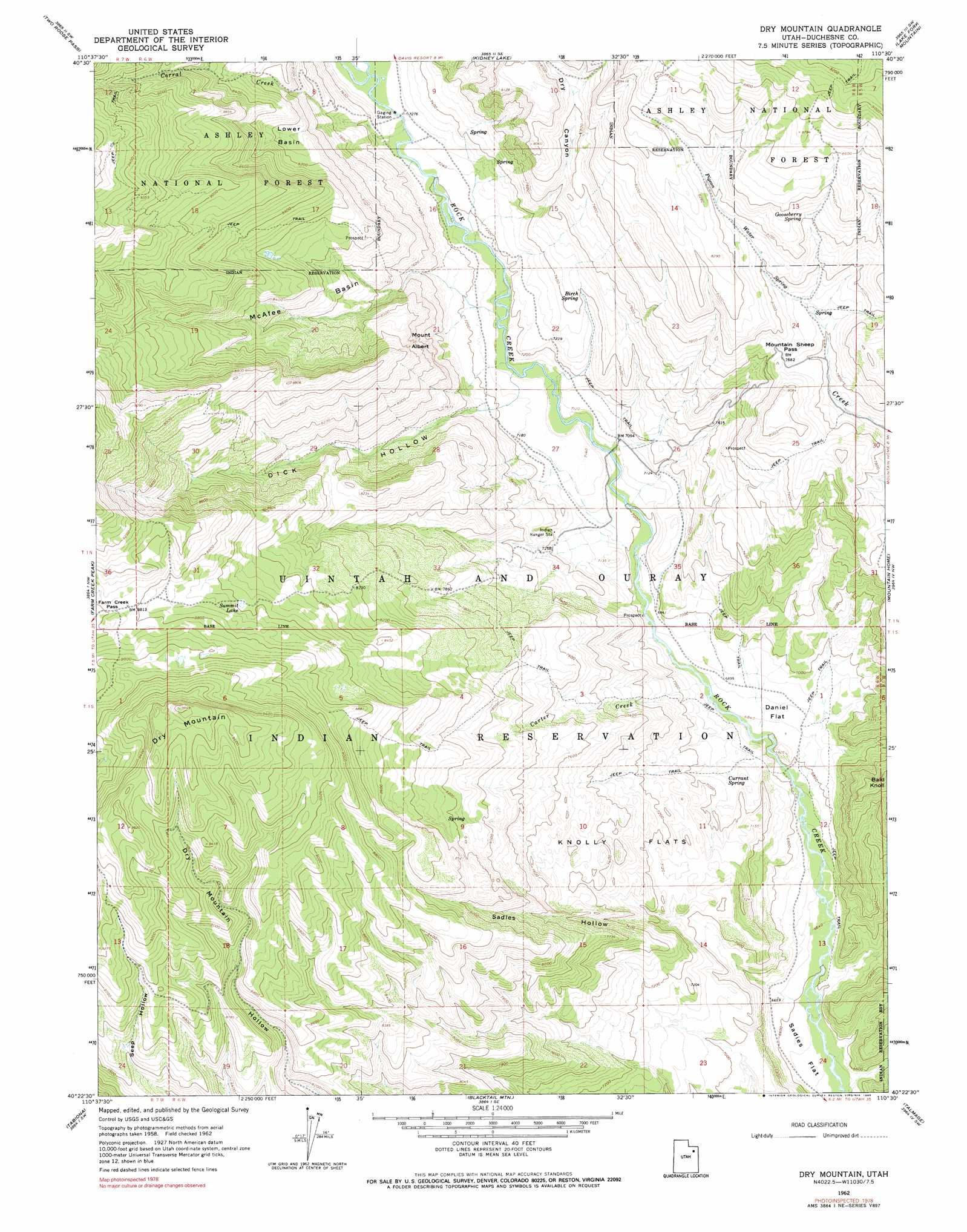
USGS Topo Quad 40110d5 - 1:24,000 scale
| Topo Map Name: | Dry Mountain |
| USGS Topo Quad ID: | 40110d5 |
| Print Size: | ca. 21 1/4" wide x 27" high |
| Southeast Coordinates: | 40.375° N latitude / 110.5° W longitude |
| Map Center Coordinates: | 40.4375° N latitude / 110.5625° W longitude |
| U.S. State: | UT |
| Filename: | o40110d5.jpg |
| Download Map JPG Image: | Dry Mountain topo map 1:24,000 scale |
| Map Type: | Topographic |
| Topo Series: | 7.5´ |
| Map Scale: | 1:24,000 |
| Source of Map Images: | United States Geological Survey (USGS) |
| Alternate Map Versions: |
Dry Mountain UT 1962, updated 1964 Download PDF Buy paper map Dry Mountain UT 1962, updated 1972 Download PDF Buy paper map Dry Mountain UT 1962, updated 1990 Download PDF Buy paper map Dry Mountain UT 1996, updated 2000 Download PDF Buy paper map Dry Mountain UT 2011 Download PDF Buy paper map Dry Mountain UT 2014 Download PDF Buy paper map |
| FStopo: | US Forest Service topo Dry Mountain is available: Download FStopo PDF Download FStopo TIF |
1:24,000 Topo Quads surrounding Dry Mountain
Hayden Peak |
Explorer Peak |
Oweep Creek |
Garfield Basin |
Mount Emmons |
Grandaddy Lake |
Tworoose Pass |
Kidney Lake |
Lake Fork Mountain |
Burnt Mill Spring |
Hanna |
Farm Creek Peak |
Dry Mountain |
Mountain Home |
Altonah |
Tabby Mountain |
Tabiona |
Blacktail Mountain |
Talmage |
Altamont |
Fruitland |
Strawberry Pinnacles |
Rabbit Gulch |
Duchesne |
Duchesne Ne |
> Back to 40110a1 at 1:100,000 scale
> Back to 40110a1 at 1:250,000 scale
> Back to U.S. Topo Maps home
Dry Mountain topo map: Gazetteer
Dry Mountain: Basins
Lower Basin elevation 2481m 8139′McAfee Basin elevation 2232m 7322′
Dry Mountain: Cliffs
Mount Albert elevation 2386m 7828′Dry Mountain: Flats
Daniel Flat elevation 2093m 6866′Knolly Flats elevation 2252m 7388′
Sadies Flat elevation 1997m 6551′
Dry Mountain: Gaps
Farm Creek Pass elevation 2694m 8838′Mountain Sheep Pass elevation 2405m 7890′
Dry Mountain: Lakes
Summit Lake elevation 2619m 8592′Dry Mountain: Springs
Birch Spring elevation 2253m 7391′Currant Spring elevation 2107m 6912′
Gooseberry Spring elevation 2507m 8225′
Pigeon Water Spring elevation 2453m 8047′
Dry Mountain: Streams
Carter Creek elevation 2091m 6860′Corral Creek elevation 2206m 7237′
Dry Mountain: Summits
Dry Mountain elevation 3002m 9849′Dry Mountain: Valleys
Dick Hollow elevation 2173m 7129′Dry Canyon elevation 2232m 7322′
McKay Hollow elevation 2520m 8267′
Sadies Hollow elevation 2013m 6604′
Dry Mountain digital topo map on disk
Buy this Dry Mountain topo map showing relief, roads, GPS coordinates and other geographical features, as a high-resolution digital map file on DVD: