Hanna Topo Map Utah
To zoom in, hover over the map of Hanna
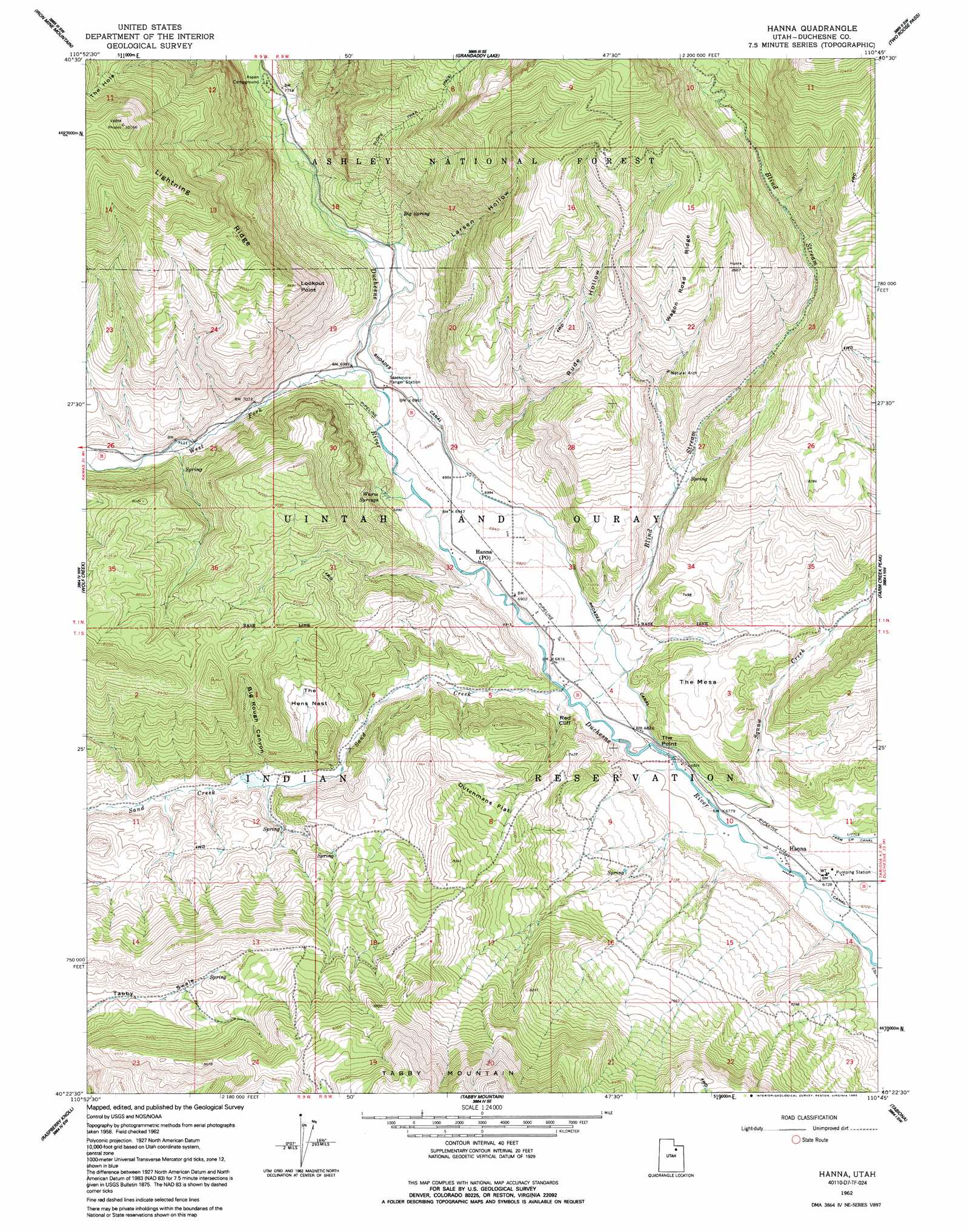
USGS Topo Quad 40110d7 - 1:24,000 scale
| Topo Map Name: | Hanna |
| USGS Topo Quad ID: | 40110d7 |
| Print Size: | ca. 21 1/4" wide x 27" high |
| Southeast Coordinates: | 40.375° N latitude / 110.75° W longitude |
| Map Center Coordinates: | 40.4375° N latitude / 110.8125° W longitude |
| U.S. State: | UT |
| Filename: | o40110d7.jpg |
| Download Map JPG Image: | Hanna topo map 1:24,000 scale |
| Map Type: | Topographic |
| Topo Series: | 7.5´ |
| Map Scale: | 1:24,000 |
| Source of Map Images: | United States Geological Survey (USGS) |
| Alternate Map Versions: |
Hanna UT 1962, updated 1963 Download PDF Buy paper map Hanna UT 1962, updated 1964 Download PDF Buy paper map Hanna UT 1962, updated 1992 Download PDF Buy paper map Hanna UT 1996, updated 2000 Download PDF Buy paper map Hanna UT 2011 Download PDF Buy paper map Hanna UT 2014 Download PDF Buy paper map |
| FStopo: | US Forest Service topo Hanna is available: Download FStopo PDF Download FStopo TIF |
1:24,000 Topo Quads surrounding Hanna
Erickson Basin |
Mirror Lake |
Hayden Peak |
Explorer Peak |
Oweep Creek |
Soapstone Basin |
Iron Mine Mountain |
Grandaddy Lake |
Tworoose Pass |
Kidney Lake |
Wolf Creek Summit |
Wolf Creek |
Hanna |
Farm Creek Peak |
Dry Mountain |
Jimmies Point |
Raspberry Knoll |
Tabby Mountain |
Tabiona |
Blacktail Mountain |
Strawberry Reservoir Ne |
Deep Creek Canyon |
Fruitland |
Strawberry Pinnacles |
Rabbit Gulch |
> Back to 40110a1 at 1:100,000 scale
> Back to 40110a1 at 1:250,000 scale
> Back to U.S. Topo Maps home
Hanna topo map: Gazetteer
Hanna: Airports
Hanna Heliport elevation 2060m 6758′Hanna: Basins
The Hens Nest elevation 2294m 7526′The Hole elevation 2795m 9169′
Hanna: Canals
Rhoades Canal elevation 2141m 7024′Hanna: Capes
Lookout Point elevation 2604m 8543′Hanna: Cliffs
Red Cliff elevation 2121m 6958′The Point elevation 2123m 6965′
Hanna: Flats
Dutchmans Flat elevation 2367m 7765′Hanna: Populated Places
Hanna elevation 2062m 6765′Hanna: Post Offices
Hanna Post Office elevation 2111m 6925′Hanna: Ridges
Wagon Road Ridge elevation 2651m 8697′Hanna: Springs
Big Spring elevation 2260m 7414′Jackass Larson Spring elevation 2171m 7122′
Warm Springs elevation 2122m 6961′
Hanna: Streams
Blind Stream elevation 2085m 6840′Sand Creek elevation 2085m 6840′
Squaw Creek elevation 2061m 6761′
West Fork Duchesne River elevation 2128m 6981′
Hanna: Summits
The Mesa elevation 2223m 7293′Hanna: Valleys
Big Rough Canyon elevation 2228m 7309′Larsen Hollow elevation 2210m 7250′
Rude Hollow elevation 2180m 7152′
Hanna digital topo map on disk
Buy this Hanna topo map showing relief, roads, GPS coordinates and other geographical features, as a high-resolution digital map file on DVD: