Bridger Lake Topo Map Utah
To zoom in, hover over the map of Bridger Lake
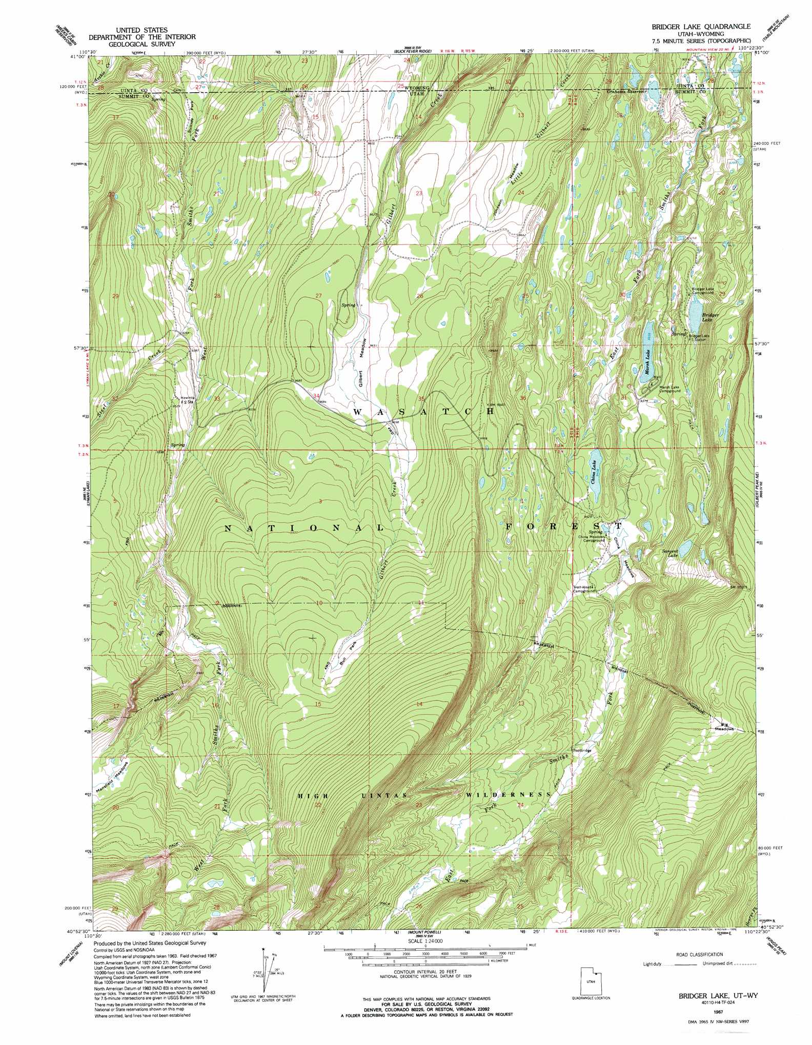
USGS Topo Quad 40110h4 - 1:24,000 scale
| Topo Map Name: | Bridger Lake |
| USGS Topo Quad ID: | 40110h4 |
| Print Size: | ca. 21 1/4" wide x 27" high |
| Southeast Coordinates: | 40.875° N latitude / 110.375° W longitude |
| Map Center Coordinates: | 40.9375° N latitude / 110.4375° W longitude |
| U.S. States: | UT, WY |
| Filename: | o40110h4.jpg |
| Download Map JPG Image: | Bridger Lake topo map 1:24,000 scale |
| Map Type: | Topographic |
| Topo Series: | 7.5´ |
| Map Scale: | 1:24,000 |
| Source of Map Images: | United States Geological Survey (USGS) |
| Alternate Map Versions: |
Bridger Lake UT 1967, updated 1969 Download PDF Buy paper map Bridger Lake UT 1967, updated 1975 Download PDF Buy paper map Bridger Lake UT 1967, updated 1995 Download PDF Buy paper map Bridger Lake UT 1998, updated 2001 Download PDF Buy paper map Bridger Lake UT 2011 Download PDF Buy paper map Bridger Lake UT 2014 Download PDF Buy paper map |
| FStopo: | US Forest Service topo Bridger Lake is available: Download FStopo PDF Download FStopo TIF |
1:24,000 Topo Quads surrounding Bridger Lake
Piedmont Reservoir |
Hague Creek |
Robertson |
Leavitt Bench |
Reed Reservoir |
Moslander Reservoir |
Meeks Cabin Reservoir |
Buck Fever Ridge |
Table Mountain |
Lonetree |
Elizabeth Mountain |
Lyman Lake |
Bridger Lake |
Gilbert Peak Ne |
Hole In The Rock |
Red Knob |
Mount Lovenia |
Mount Powell |
Kings Peak |
Fox Lake |
Explorer Peak |
Oweep Creek |
Garfield Basin |
Mount Emmons |
Bollie Lake |
> Back to 40110e1 at 1:100,000 scale
> Back to 40110a1 at 1:250,000 scale
> Back to U.S. Topo Maps home
Bridger Lake topo map: Gazetteer
Bridger Lake: Dams
China Lake Dam elevation 2888m 9475′Marsh Lake Dam elevation 2847m 9340′
Bridger Lake: Flats
Big Meadows elevation 3140m 10301′Bull Park elevation 3074m 10085′
China Meadows elevation 2866m 9402′
Gilbert Meadow elevation 2946m 9665′
Johnson Meadows elevation 2920m 9580′
Mansfield Meadows elevation 3118m 10229′
Bridger Lake: Lakes
Bridger Lake elevation 2850m 9350′China Lake elevation 2869m 9412′
Marsh Lake elevation 2847m 9340′
Sargent Lake elevation 2954m 9691′
Bridger Lake: Parks
Suicide Park elevation 2742m 8996′Bridger Lake: Reservoirs
China Lake elevation 2888m 9475′Grahams Reservoir elevation 2810m 9219′
Marsh Lake elevation 2847m 9340′
Stateline Reservoir elevation 2775m 9104′
Bridger Lake: Streams
Steel Creek elevation 2836m 9304′Bridger Lake: Trails
High Line Trail elevation 3182m 10439′Bridger Lake digital topo map on disk
Buy this Bridger Lake topo map showing relief, roads, GPS coordinates and other geographical features, as a high-resolution digital map file on DVD: