Jimmies Point Topo Map Utah
To zoom in, hover over the map of Jimmies Point
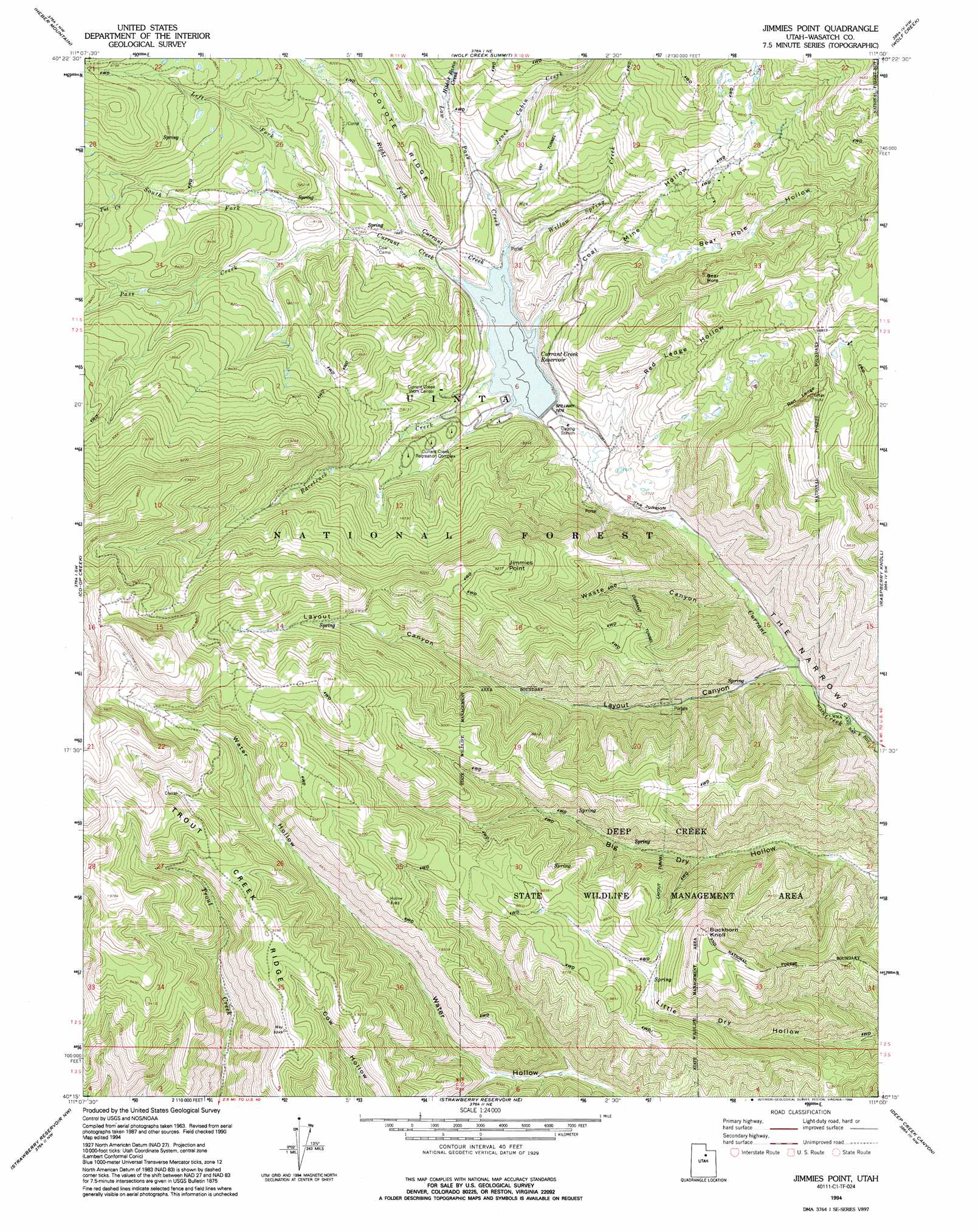
USGS Topo Quad 40111c1 - 1:24,000 scale
| Topo Map Name: | Jimmies Point |
| USGS Topo Quad ID: | 40111c1 |
| Print Size: | ca. 21 1/4" wide x 27" high |
| Southeast Coordinates: | 40.25° N latitude / 111° W longitude |
| Map Center Coordinates: | 40.3125° N latitude / 111.0625° W longitude |
| U.S. State: | UT |
| Filename: | o40111c1.jpg |
| Download Map JPG Image: | Jimmies Point topo map 1:24,000 scale |
| Map Type: | Topographic |
| Topo Series: | 7.5´ |
| Map Scale: | 1:24,000 |
| Source of Map Images: | United States Geological Survey (USGS) |
| Alternate Map Versions: |
Jimmies Point UT 1967, updated 1970 Download PDF Buy paper map Jimmies Point UT 1967, updated 1980 Download PDF Buy paper map Jimmies Point UT 1967, updated 1985 Download PDF Buy paper map Jimmies Point UT 1994, updated 1994 Download PDF Buy paper map Jimmies Point UT 1998, updated 2002 Download PDF Buy paper map Jimmies Point UT 2011 Download PDF Buy paper map Jimmies Point UT 2014 Download PDF Buy paper map |
| FStopo: | US Forest Service topo Jimmies Point is available: Download FStopo PDF Download FStopo TIF |
1:24,000 Topo Quads surrounding Jimmies Point
Francis |
Woodland |
Soapstone Basin |
Iron Mine Mountain |
Grandaddy Lake |
Center Creek |
Heber Mountain |
Wolf Creek Summit |
Wolf Creek |
Hanna |
Twin Peaks |
Co-Op Creek |
Jimmies Point |
Raspberry Knoll |
Tabby Mountain |
Two Tom Hill |
Strawberry Reservoir Nw |
Strawberry Reservoir Ne |
Deep Creek Canyon |
Fruitland |
Rays Valley |
Strawberry Reservoir Sw |
Strawberry Reservoir Se |
Strawberry Peak |
Avintaquin Canyon |
> Back to 40111a1 at 1:100,000 scale
> Back to 40110a1 at 1:250,000 scale
> Back to U.S. Topo Maps home
Jimmies Point topo map: Gazetteer
Jimmies Point: Basins
Bear Hole elevation 2585m 8480′Jimmies Point: Canals
Layout Tunnel elevation 2638m 8654′Jimmies Point: Cliffs
Red Ledge elevation 2684m 8805′The Jumpoff elevation 2308m 7572′
Jimmies Point: Dams
Currant Creek Dam elevation 2342m 7683′Jimmies Point: Gaps
The Narrows elevation 2240m 7349′Jimmies Point: Reservoirs
Currant Creek Reservoir elevation 2342m 7683′Jimmies Point: Ridges
Trout Creek Ridge elevation 2825m 9268′Jimmies Point: Streams
Hildas Basin Creek elevation 2414m 7919′Jones Cabin Creek elevation 2377m 7798′
Left Fork Currant Creek elevation 2395m 7857′
Low Pass Creek elevation 2342m 7683′
Pass Creek elevation 2377m 7798′
Racetrack Creek elevation 2342m 7683′
Right Fork Currant Creek elevation 2342m 7683′
South Fork Currant Creek elevation 2395m 7857′
Tut Creek elevation 2535m 8316′
Willow Spring Creek elevation 2338m 7670′
Jimmies Point: Summits
Buckhorn Knoll elevation 2813m 9229′Jimmies Point elevation 2824m 9265′
Jimmies Point: Valleys
Bear Hole Hollow elevation 2428m 7965′Coal Mine Hollow elevation 2342m 7683′
Layout Canyon elevation 2229m 7312′
Red Ledge Hollow elevation 2302m 7552′
Waste Canyon elevation 2256m 7401′
Jimmies Point digital topo map on disk
Buy this Jimmies Point topo map showing relief, roads, GPS coordinates and other geographical features, as a high-resolution digital map file on DVD: