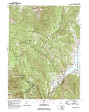
Aspen Grove Topo Map Utah
To zoom in, hover over the map of Aspen Grove
USGS Topo Quad 40111d5 - 1:24,000 scale
| Topo Map Name: | Aspen Grove |
| USGS Topo Quad ID: | 40111d5 |
| Print Size: | ca. 21 1/4" wide x 27" high |
| Southeast Coordinates: | 40.375° N latitude / 111.5° W longitude |
| Map Center Coordinates: | 40.4375° N latitude / 111.5625° W longitude |
| U.S. State: | UT |
| Filename: | o40111d5.jpg |
| Download Map JPG Image: | Aspen Grove topo map 1:24,000 scale |
| Map Type: | Topographic |
| Topo Series: | 7.5´ |
| Map Scale: | 1:24,000 |
| Source of Map Images: | United States Geological Survey (USGS) |
| Alternate Map Versions: |
Aspen Grove UT 1948, updated 1960 Download PDF Buy paper map Aspen Grove UT 1948, updated 1971 Download PDF Buy paper map Aspen Grove UT 1948, updated 1983 Download PDF Buy paper map Aspen Grove UT 1950 Download PDF Buy paper map Aspen Grove UT 1993, updated 1994 Download PDF Buy paper map Aspen Grove UT 1993, updated 1994 Download PDF Buy paper map Aspen Grove UT 1998, updated 2000 Download PDF Buy paper map Aspen Grove UT 2011 Download PDF Buy paper map Aspen Grove UT 2014 Download PDF Buy paper map |
| FStopo: | US Forest Service topo Aspen Grove is available: Download FStopo PDF Download FStopo TIF |
1:24,000 Topo Quads surrounding Aspen Grove
> Back to 40111a1 at 1:100,000 scale
> Back to 40110a1 at 1:250,000 scale
> Back to U.S. Topo Maps home
Aspen Grove topo map: Gazetteer
Aspen Grove: Basins
The Cove elevation 2011m 6597′Aspen Grove: Benches
Weeks Bench elevation 1675m 5495′Aspen Grove: Capes
Elk Point elevation 2604m 8543′Aspen Grove: Dams
Deer Creek Dam elevation 1623m 5324′Aspen Grove: Falls
Stewarts Cascades elevation 2092m 6863′Aspen Grove: Flats
Pine Flat elevation 2251m 7385′Aspen Grove: Lakes
Dry Lake elevation 2190m 7185′Aspen Grove: Parks
Deer Creek State Park elevation 1683m 5521′Sundance Ski Area elevation 1980m 6496′
Wasatch Mountain State Park elevation 1860m 6102′
Aspen Grove: Populated Places
Aspen Grove elevation 2093m 6866′Riverbend Trailer Park elevation 1606m 5269′
Sundance elevation 1874m 6148′
Aspen Grove: Reservoirs
Deer Creek Reservoir elevation 1639m 5377′Aspen Grove: Ridges
North Fork Ridge elevation 2320m 7611′Aspen Grove: Springs
Cascade Springs elevation 1926m 6318′Decker Spring elevation 1876m 6154′
Mill Canyon Spring elevation 2525m 8284′
Mud Spring elevation 2433m 7982′
Rock Spring elevation 2881m 9452′
Sulphur Spring elevation 1694m 5557′
Tooth Spring elevation 2219m 7280′
Aspen Grove: Streams
Decker Creek elevation 1652m 5419′Provo Deer Creek elevation 1614m 5295′
Red Pine Creek elevation 2168m 7112′
South Fork Deer Creek elevation 1753m 5751′
Aspen Grove: Summits
Mill Canyon Peak elevation 3150m 10334′Aspen Grove: Trails
Mount Timpanogos Trail elevation 2157m 7076′Aspen Grove: Valleys
Bear Canyon elevation 1596m 5236′Bear Canyon elevation 1902m 6240′
Hoovers Hollow elevation 1663m 5456′
Long Hollow elevation 1643m 5390′
Pole Canyon elevation 1747m 5731′
Scotts Hollow elevation 1657m 5436′
Soldier Hollow elevation 1719m 5639′
Sunday Canyon elevation 1660m 5446′
Thomas Canyon elevation 1936m 6351′
Aspen Grove digital topo map on disk
Buy this Aspen Grove topo map showing relief, roads, GPS coordinates and other geographical features, as a high-resolution digital map file on DVD:


