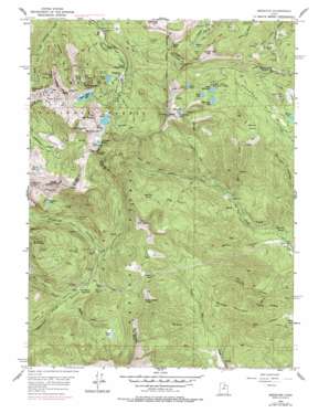
Brighton Topo Map Utah
To zoom in, hover over the map of Brighton
USGS Topo Quad 40111e5 - 1:24,000 scale
| Topo Map Name: | Brighton |
| USGS Topo Quad ID: | 40111e5 |
| Print Size: | ca. 21 1/4" wide x 27" high |
| Southeast Coordinates: | 40.5° N latitude / 111.5° W longitude |
| Map Center Coordinates: | 40.5625° N latitude / 111.5625° W longitude |
| U.S. State: | UT |
| Filename: | o40111e5.jpg |
| Download Map JPG Image: | Brighton topo map 1:24,000 scale |
| Map Type: | Topographic |
| Topo Series: | 7.5´ |
| Map Scale: | 1:24,000 |
| Source of Map Images: | United States Geological Survey (USGS) |
| Alternate Map Versions: |
Brighton UT 1955, updated 1957 Download PDF Buy paper map Brighton UT 1955, updated 1960 Download PDF Buy paper map Brighton UT 1955, updated 1970 Download PDF Buy paper map Brighton UT 1955, updated 1978 Download PDF Buy paper map Brighton UT 1998, updated 2001 Download PDF Buy paper map Brighton UT 2011 Download PDF Buy paper map Brighton UT 2014 Download PDF Buy paper map |
| FStopo: | US Forest Service topo Brighton is available: Download FStopo PDF Download FStopo TIF |
1:24,000 Topo Quads surrounding Brighton
> Back to 40111e1 at 1:100,000 scale
> Back to 40110a1 at 1:250,000 scale
> Back to U.S. Topo Maps home
Brighton topo map: Gazetteer
Brighton: Airports
Brighton Ski Area Heliport elevation 2660m 8727′Solitude Ski Area Heliport elevation 2622m 8602′
Brighton: Basins
Albion Basin elevation 2858m 9376′Boulder Basin elevation 2648m 8687′
Brighton: Cliffs
Honeycomb Cliffs elevation 3047m 9996′Brighton: Dams
Lake Mary Dam elevation 2894m 9494′Silver Lake Dam elevation 2832m 9291′
Silver Lake Islet Dam elevation 2775m 9104′
Twin Lakes Dam elevation 2875m 9432′
Brighton: Flats
Big Flat elevation 2530m 8300′Bonanza Flat elevation 2583m 8474′
Giles Flat elevation 2527m 8290′
Graveyard Flat elevation 2308m 7572′
Mill Flat elevation 2061m 6761′
Brighton: Gaps
Guardsman Pass elevation 2955m 9694′Pole Line Pass elevation 2731m 8959′
Sandy Baker Pass elevation 2675m 8776′
Scotts Pass elevation 2889m 9478′
Brighton: Lakes
Dog Lake elevation 2860m 9383′Lackawaxen Lake elevation 3042m 9980′
Lake Brimhall elevation 2787m 9143′
Lake Catherine elevation 3032m 9947′
Lake Martha elevation 2922m 9586′
Pittsburg Lake elevation 2873m 9425′
Shadow Lake elevation 2739m 8986′
Brighton: Mines
Alta Tunnel elevation 2605m 8546′American Tunnel elevation 2835m 9301′
Anchor Mine elevation 2694m 8838′
Anchor Tunnel elevation 2564m 8412′
Apex Mine elevation 2672m 8766′
Bay State Tunnel elevation 2366m 7762′
Big Cottonwood Mine elevation 2932m 9619′
Black Bess Shaft elevation 3045m 9990′
Bog Mine elevation 2685m 8809′
California Mine elevation 2680m 8792′
Comstock Mine elevation 2645m 8677′
Daly West Mine elevation 2551m 8369′
Dutchman Mine elevation 2322m 7618′
Flagstaff Mine elevation 2772m 9094′
Iowa Copper Tunnel elevation 2755m 9038′
Jones Shaft elevation 2688m 8818′
Jupiter Mine elevation 2828m 9278′
Little Bell Shaft elevation 2619m 8592′
Little Dollie Tunnel elevation 2504m 8215′
Lucky Bill elevation 2740m 8989′
Michigan-Utah Mine elevation 2985m 9793′
Midwest Tunnel elevation 2933m 9622′
Miller Hill Tunnel elevation 2345m 7693′
Mountain Dell Mine elevation 2594m 8510′
New York Tunnel elevation 2743m 8999′
Pacific Mine elevation 2382m 7814′
Prince of Wales Shaft elevation 3034m 9954′
Quincy Mine elevation 2578m 8458′
Scottish Chief Mine elevation 2994m 9822′
Solitude Tunnel elevation 2793m 9163′
Steamboat Tunnel elevation 2641m 8664′
Sunday Tunnel elevation 2979m 9773′
Texan Tunnel elevation 2662m 8733′
USLM 4 Mine elevation 2831m 9288′
Walker and Webster Mine elevation 2573m 8441′
Woodlawn Mine elevation 2823m 9261′
Wyoming Tunnel elevation 3044m 9986′
Brighton: Pillars
Devils Castle elevation 3307m 10849′Brighton: Populated Places
Albion Alps elevation 2826m 9271′Albion Basin elevation 2826m 9271′
Brighton elevation 2654m 8707′
Forest Glen elevation 2654m 8707′
Lady of the Lake elevation 2664m 8740′
Silver Lake Estates elevation 2661m 8730′
Silver Lake Summer Resort elevation 2656m 8713′
Solitude elevation 2481m 8139′
Brighton: Post Offices
Brighton Post Office (historical) elevation 2654m 8707′Brighton: Reservoirs
Bloods Lake elevation 2901m 9517′Forest Lake elevation 2594m 8510′
Lake Mary elevation 2894m 9494′
Lake Solitude elevation 2766m 9074′
Midway Reservoir elevation 2537m 8323′
Secret Lake elevation 3008m 9868′
Silver Lake elevation 2656m 8713′
Silver Lake elevation 2836m 9304′
Silver Lake Islet elevation 2775m 9104′
Twin Lakes Reservoir elevation 2886m 9468′
Brighton: Ridges
Pioneer Ridge elevation 2880m 9448′Brighton: Springs
Big Flat Spring elevation 2679m 8789′Big Spring elevation 2376m 7795′
Epperson Spring elevation 1883m 6177′
Brighton: Streams
Baker Fork elevation 2328m 7637′Lavina Creek elevation 2051m 6729′
Lundeen Creek elevation 2190m 7185′
Shaffer Fork elevation 2302m 7552′
Brighton: Summits
Ant Knolls elevation 3003m 9852′Clayton Peak elevation 3257m 10685′
Davenport Hill elevation 3072m 10078′
Jupiter Hill elevation 3042m 9980′
Lone Hill elevation 2707m 8881′
Middle Mountain elevation 2492m 8175′
Miller Hill elevation 3014m 9888′
Mount Evergreen elevation 3002m 9849′
Mount Millicent elevation 3170m 10400′
Mount Tuscarora elevation 3236m 10616′
Mount Wolverine elevation 3281m 10764′
Pioneer Peak elevation 3178m 10426′
Scott Hill elevation 3063m 10049′
Sugarloaf Mountain elevation 3252m 10669′
Sunset Peak elevation 3252m 10669′
Brighton: Tunnels
Centennial Tunnel elevation 2555m 8382′Smuggler Tunnel elevation 2777m 9110′
Snake Creek Tunnel elevation 2529m 8297′
Brighton: Valleys
Bonner Hollow elevation 1842m 6043′Dry Fork elevation 2361m 7746′
Faucett Canyon elevation 1843m 6046′
Honeycomb Fork elevation 2508m 8228′
Lime Canyon elevation 1853m 6079′
Mary Ellen Gulch elevation 2286m 7500′
Mill F East Fork elevation 2493m 8179′
Mill F South Fork elevation 2513m 8244′
Pot Hollow elevation 2265m 7431′
Sids Canyon elevation 1831m 6007′
Brighton digital topo map on disk
Buy this Brighton topo map showing relief, roads, GPS coordinates and other geographical features, as a high-resolution digital map file on DVD:


