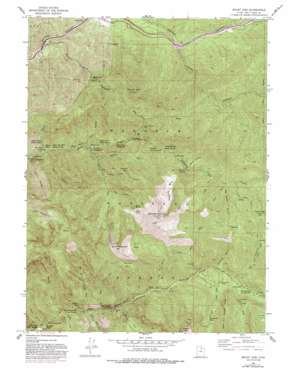
Mount Aire Topo Map Utah
To zoom in, hover over the map of Mount Aire
USGS Topo Quad 40111f6 - 1:24,000 scale
| Topo Map Name: | Mount Aire |
| USGS Topo Quad ID: | 40111f6 |
| Print Size: | ca. 21 1/4" wide x 27" high |
| Southeast Coordinates: | 40.625° N latitude / 111.625° W longitude |
| Map Center Coordinates: | 40.6875° N latitude / 111.6875° W longitude |
| U.S. State: | UT |
| Filename: | o40111f6.jpg |
| Download Map JPG Image: | Mount Aire topo map 1:24,000 scale |
| Map Type: | Topographic |
| Topo Series: | 7.5´ |
| Map Scale: | 1:24,000 |
| Source of Map Images: | United States Geological Survey (USGS) |
| Alternate Map Versions: |
Mount Aire UT 1955, updated 1957 Download PDF Buy paper map Mount Aire UT 1955, updated 1961 Download PDF Buy paper map Mount Aire UT 1955, updated 1973 Download PDF Buy paper map Mount Aire UT 1955, updated 1978 Download PDF Buy paper map Mount Aire UT 1955, updated 1987 Download PDF Buy paper map Mount Aire UT 1955, updated 1993 Download PDF Buy paper map Mount Aire UT 1998, updated 2001 Download PDF Buy paper map Mount Aire UT 2011 Download PDF Buy paper map Mount Aire UT 2014 Download PDF Buy paper map |
| FStopo: | US Forest Service topo Mount Aire is available: Download FStopo PDF Download FStopo TIF |
1:24,000 Topo Quads surrounding Mount Aire
> Back to 40111e1 at 1:100,000 scale
> Back to 40110a1 at 1:250,000 scale
> Back to U.S. Topo Maps home
Mount Aire topo map: Gazetteer
Mount Aire: Basins
Alexander Basin elevation 2550m 8366′Greens Basin elevation 2552m 8372′
Maxfield Basin elevation 2718m 8917′
Mill A Basin elevation 2757m 9045′
Mount Aire: Falls
Doughnut Falls elevation 2415m 7923′Hidden Falls elevation 1959m 6427′
Mount Aire: Flats
Reynolds Flat elevation 2245m 7365′Mount Aire: Forests
Wasatch National Forest elevation 2614m 8576′Mount Aire: Gaps
White Fir Pass elevation 2367m 7765′Mount Aire: Lakes
Dog Lake elevation 2665m 8743′Mount Aire: Mines
Baker Mine elevation 2693m 8835′Maxfield Mine elevation 2149m 7050′
Mount Aire: Pillars
Santa Claus Rock elevation 1779m 5836′Mount Aire: Populated Places
Canyon Enterprises elevation 1778m 5833′Lost Acres elevation 2259m 7411′
Merrywood elevation 2071m 6794′
Mount Aire elevation 1976m 6482′
Mounthaven elevation 2212m 7257′
Pine Lodge elevation 2224m 7296′
Mount Aire: Springs
Baker Spring elevation 2709m 8887′Bowman Spring elevation 2278m 7473′
Neffs Spring elevation 2675m 8776′
Thousand Springs elevation 2333m 7654′
Mount Aire: Streams
Bowman Fork elevation 1886m 6187′Broads Fork elevation 1823m 5980′
Butler Fork elevation 2168m 7112′
Church Fork elevation 1739m 5705′
Days Fork elevation 2228m 7309′
Elbow Fork elevation 2017m 6617′
Elbow Fork elevation 2003m 6571′
Mill B North Fork elevation 1865m 6118′
Mill B South Fork elevation 1922m 6305′
Mill D North Fork elevation 2222m 7290′
Mill D South Fork elevation 2160m 7086′
Mineral Fork elevation 2042m 6699′
Porter Fork elevation 1815m 5954′
Soldier Fork elevation 2313m 7588′
Whipple Fork elevation 1809m 5935′
Wilson Fork elevation 2283m 7490′
Mount Aire: Summits
Gobblers Knob elevation 3115m 10219′Kesler Peak elevation 3166m 10387′
Little Water Peak elevation 2929m 9609′
Mount Aire elevation 2622m 8602′
Mount Raymond elevation 3108m 10196′
Mount Aire: Valleys
Big Water Gulch elevation 2329m 7641′Birch Hollow elevation 2195m 7201′
Burch Hollow elevation 1833m 6013′
Lambs Canyon elevation 1873m 6145′
Little Water Gulch elevation 2870m 9416′
Mill Gulch elevation 2122m 6961′
Mount Aire Canyon elevation 1625m 5331′
Mule Hollow elevation 1778m 5833′
Pole Canyon elevation 2126m 6975′
Reynolds Gulch elevation 2210m 7250′
Thayne Canyon elevation 1759m 5770′
Yellow Jacket Gulch elevation 2030m 6660′
Mount Aire digital topo map on disk
Buy this Mount Aire topo map showing relief, roads, GPS coordinates and other geographical features, as a high-resolution digital map file on DVD:


