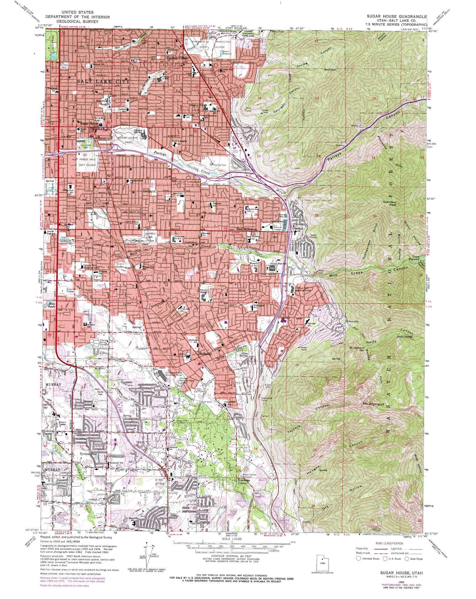
Sugar House Topo Map Utah
To zoom in, hover over the map of Sugar House
USGS Topo Quad 40111f7 - 1:24,000 scale
| Topo Map Name: | Sugar House |
| USGS Topo Quad ID: | 40111f7 |
| Print Size: | ca. 21 1/4" wide x 27" high |
| Southeast Coordinates: | 40.625° N latitude / 111.75° W longitude |
| Map Center Coordinates: | 40.6875° N latitude / 111.8125° W longitude |
| U.S. State: | UT |
| Filename: | o40111f7.jpg |
| Download Map JPG Image: | Sugar House topo map 1:24,000 scale |
| Map Type: | Topographic |
| Topo Series: | 7.5´ |
| Map Scale: | 1:24,000 |
| Source of Map Images: | United States Geological Survey (USGS) |
| Alternate Map Versions: |
Sugar House UT 1952, updated 1954 Download PDF Buy paper map Sugar House UT 1952, updated 1954 Download PDF Buy paper map Sugar House UT 1963, updated 1964 Download PDF Buy paper map Sugar House UT 1963, updated 1971 Download PDF Buy paper map Sugar House UT 1963, updated 1978 Download PDF Buy paper map Sugar House UT 1998, updated 2001 Download PDF Buy paper map Sugar House UT 2011 Download PDF Buy paper map Sugar House UT 2014 Download PDF Buy paper map |
| FStopo: | US Forest Service topo Sugar House is available: Download FStopo PDF Download FStopo TIF |
1:24,000 Topo Quads surrounding Sugar House
Saltair Ne |
Farmington |
Bountiful Peak |
Porterville |
East Canyon Reservoir |
Saltair |
Salt Lake City North |
Fort Douglas |
Mountain Dell |
Big Dutch Hollow |
Magna |
Salt Lake City South |
Sugar House |
Mount Aire |
Park City West |
Lark |
Midvale |
Draper |
Dromedary Peak |
Brighton |
Tickville Spring |
Jordan Narrows |
Lehi |
Timpanogos Cave |
Aspen Grove |
> Back to 40111e1 at 1:100,000 scale
> Back to 40110a1 at 1:250,000 scale
> Back to U.S. Topo Maps home
Sugar House topo map: Gazetteer
Sugar House: Airports
LDS Hospital North Heliport elevation 1308m 4291′Saint Marks Hospital Heliport elevation 1318m 4324′
Sugar House: Areas
Hogle Zoological Gardens elevation 1474m 4835′Sugar House: Bridges
Black Bridge elevation 1340m 4396′Sugar House: Canals
Big Ditch Canal elevation 1310m 4297′Granite Flume elevation 1660m 5446′
Upper Canal elevation 1398m 4586′
Upper Canal elevation 1387m 4550′
Sugar House: Crossings
Interchange 1 elevation 1439m 4721′Interchange 125 elevation 1312m 4304′
Interchange 126 elevation 1340m 4396′
Interchange 127 elevation 1388m 4553′
Interchange 128 elevation 1406m 4612′
Interchange 129 elevation 1481m 4858′
Interchange 130 elevation 1481m 4858′
Interchange 131 elevation 1491m 4891′
Interchange 2 elevation 1478m 4849′
Interchange 3 elevation 1507m 4944′
Interchange 4 elevation 1501m 4924′
Interchange 5 elevation 1488m 4881′
Interchange 7 elevation 1401m 4596′
Interchange 8 elevation 1357m 4452′
Interchange 9 elevation 1336m 4383′
Sugar House: Lakes
Hills Ponds elevation 1302m 4271′Sugar House: Parks
Big Cottonwood Barrier Free Park elevation 1322m 4337′Big Cottonwood Regional Park elevation 1320m 4330′
Cottonwood Regional Park elevation 1313m 4307′
Detention Basin Park elevation 1319m 4327′
Fairmount Park elevation 1323m 4340′
Hillview Detention Basin Park elevation 1309m 4294′
Laird Park elevation 1411m 4629′
Liberty Park elevation 1299m 4261′
Malmsten Amphiteater elevation 1336m 4383′
Miller Park elevation 1396m 4580′
Nibley Park elevation 1303m 4274′
Sugar House Monument elevation 1327m 4353′
Sugar House Park elevation 1348m 4422′
Tracy Aviary elevation 1299m 4261′
Sugar House: Populated Places
Adams Park elevation 1339m 4393′Aix La Chapelle Condominium elevation 1353m 4438′
Akron elevation 1345m 4412′
Andlor elevation 1377m 4517′
Angie Circle Condominium elevation 1317m 4320′
Apple Blossom Estate elevation 1321m 4333′
Applewood elevation 1354m 4442′
Arbor Estates elevation 1348m 4422′
Arbor Estates Condominium elevation 1348m 4422′
Arborwood Park elevation 1339m 4393′
Arcadia Park Condominium elevation 1359m 4458′
Arcadian Park elevation 1357m 4452′
Artistic Terrace elevation 1401m 4596′
Ballard elevation 1426m 4678′
Bay elevation 1337m 4386′
Bee and Gee elevation 1334m 4376′
Belle Meadows elevation 1330m 4363′
Bellwood Acres elevation 1385m 4543′
Bev Wood Estates elevation 1447m 4747′
Bevwood elevation 1382m 4534′
Bevwood Acres elevation 1419m 4655′
Birch Point Condominium elevation 1323m 4340′
Birchwood Estates elevation 1325m 4347′
Biscayne Park elevation 1359m 4458′
Blackburn elevation 1391m 4563′
Blue Grass Acres elevation 1347m 4419′
Blue Ribbon Acres elevation 1358m 4455′
Blue Spruce elevation 1382m 4534′
Blue Spruce Heights elevation 1385m 4543′
Bonnie Brae elevation 1459m 4786′
Bonnie View elevation 1479m 4852′
Boulevard elevation 1348m 4422′
Bowthorpe elevation 1375m 4511′
Boyes Acres elevation 1351m 4432′
Bradford elevation 1317m 4320′
Brentwood Park elevation 1341m 4399′
Briarcreek Condominium elevation 1391m 4563′
Briarcreek Estates elevation 1386m 4547′
Briarwood Estates elevation 1376m 4514′
Briarwood Hills elevation 1386m 4547′
Brigham Madsen elevation 1310m 4297′
Brimhall elevation 1413m 4635′
Brimley elevation 1422m 4665′
Broadbent elevation 1429m 4688′
Brockwood elevation 1317m 4320′
Bron Breck elevation 1424m 4671′
Brookside Park elevation 1343m 4406′
Brookstone Condo elevation 1348m 4422′
Brookwood elevation 1323m 4340′
Brookwood Condominiums elevation 1318m 4324′
Brubaker Park elevation 1430m 4691′
C Barton Grover elevation 1350m 4429′
Calann elevation 1336m 4383′
Callister elevation 1391m 4563′
Cambria Pines elevation 1402m 4599′
Cambridge Estates elevation 1334m 4376′
Canterbay Estates elevation 1336m 4383′
Canyon Cove elevation 1514m 4967′
Canyon Rim elevation 1407m 4616′
Carole Addition elevation 1320m 4330′
Carriage Lane Condominium elevation 1364m 4475′
Carsey Acres elevation 1313m 4307′
Carters Circle elevation 1347m 4419′
Castlefield Downs elevation 1339m 4393′
Casto Gardens elevation 1379m 4524′
Casto Pines Condominium elevation 1365m 4478′
Castro Heoghts elevation 1435m 4708′
Centennial Estates elevation 1341m 4399′
Charleston Place elevation 1343m 4406′
Chevy Chase elevation 1330m 4363′
Clayton elevation 1332m 4370′
Cliffwood Park elevation 1380m 4527′
Convest elevation 1313m 4307′
Cottonwood elevation 1336m 4383′
Cottonwood Acres elevation 1367m 4484′
Cottonwood Estates elevation 1356m 4448′
Cottonwood Glade elevation 1352m 4435′
Cottonwood Grove Condominium elevation 1343m 4406′
Cottonwood Hills elevation 1435m 4708′
Cottonwood Manor elevation 1462m 4796′
Cottonwood Meadows elevation 1333m 4373′
Cottonwood Meadows Estates elevation 1328m 4356′
Cottonwood Park elevation 1340m 4396′
Cottonwood Ridge elevation 1456m 4776′
Cottonwood Village elevation 1356m 4448′
Cottonwoods of Holladay elevation 1354m 4442′
Country Corners Condominium elevation 1318m 4324′
Country Garden Estates elevation 1342m 4402′
Country Manor elevation 1386m 4547′
Countryside Condominium elevation 1345m 4412′
Cove on Mount Olympus Place elevation 1506m 4940′
Coventry at Fairmeadows elevation 1352m 4435′
Creekside East Condominium elevation 1313m 4307′
Cresthill Circle elevation 1353m 4438′
Crestwood elevation 1331m 4366′
Crown Colony elevation 1319m 4327′
Crus elevation 1318m 4324′
Dairy Meadows elevation 1330m 4363′
Dawn Circle elevation 1354m 4442′
Deerfield Condominium elevation 1409m 4622′
Del Ann elevation 1346m 4416′
Donjean elevation 1319m 4327′
Dover Hill Condominium elevation 1323m 4340′
Driftwood Estates elevation 1341m 4399′
Dublin Town elevation 2115m 6938′
East Cottonwood Heights elevation 1378m 4520′
East Holladay Condominium elevation 1440m 4724′
East Holladay Slopes elevation 1460m 4790′
East Meadows elevation 1319m 4327′
East Millcreek elevation 1455m 4773′
East Olympus Heights elevation 1413m 4635′
Easton in Holladay Condominium elevation 1346m 4416′
Eastview elevation 1330m 4363′
Eddie Kay elevation 1319m 4327′
Edgewood Estates elevation 1327m 4353′
Edinburgh of Holladay Condominium elevation 1319m 4327′
El Rancho elevation 1319m 4327′
Ellison Woods elevation 1373m 4504′
Elm Wood elevation 1356m 4448′
Enchanted Village elevation 1347m 4419′
Erekson Dairy elevation 1327m 4353′
Esquire Acres elevation 1422m 4665′
Esquire Acres Five elevation 1390m 4560′
Ethel Gardens elevation 1316m 4317′
Ewell elevation 1311m 4301′
Executive Suites of Fountain East elevation 1324m 4343′
Fairbrook Condominium elevation 1336m 4383′
Fairmeadows Condo elevation 1348m 4422′
Fairview Gardens elevation 1345m 4412′
Fairway Estates Condominium elevation 1316m 4317′
Fardown Estates elevation 1353m 4438′
Farley elevation 1425m 4675′
Farm Hill elevation 1310m 4297′
Farnsworth Condominium elevation 1346m 4416′
Fawn Gardens elevation 1344m 4409′
Fischner Phillips Condominium elevation 1319m 4327′
Flamingo Hills elevation 1366m 4481′
Florence Hollow elevation 1387m 4550′
Floribunda Heights elevation 1395m 4576′
Fontaine Bleu elevation 1339m 4393′
Foothill elevation 1420m 4658′
Foothill Village elevation 1424m 4671′
Forest Dale elevation 1319m 4327′
Fors elevation 1333m 4373′
Fuller Gardens elevation 1329m 4360′
Garden Acres elevation 1316m 4317′
Gill elevation 1357m 4452′
Green Meadows elevation 1344m 4409′
Green Valley elevation 1308m 4291′
Greenfield Village elevation 1361m 4465′
Hamilton Village elevation 1313m 4307′
Haven Grove elevation 1345m 4412′
Haven Place elevation 1347m 4419′
Heather Circle elevation 1376m 4514′
Helm elevation 1375m 4511′
Heughs Canyon elevation 1490m 4888′
Hidden Lake Condominium elevation 1311m 4301′
Hidden Village elevation 1345m 4412′
Highland Drive Park elevation 1325m 4347′
Highland Orchard Condominium elevation 1329m 4360′
Hillsden Addition elevation 1352m 4435′
Hillside Village elevation 1412m 4632′
Hilton Villa elevation 1332m 4370′
Holiday Center Addition elevation 1327m 4353′
Holladay elevation 1361m 4465′
Holladay Acres elevation 1338m 4389′
Holladay Circle elevation 1338m 4389′
Holladay Creek Condominium elevation 1334m 4376′
Holladay East elevation 1468m 4816′
Holladay Edgehill elevation 1354m 4442′
Holladay Estates elevation 1356m 4448′
Holladay Gardens elevation 1368m 4488′
Holladay Grove elevation 1325m 4347′
Holladay Haven Condominium elevation 1337m 4386′
Holladay Heights elevation 1386m 4547′
Holladay Highlands elevation 1373m 4504′
Holladay Highlands Three elevation 1394m 4573′
Holladay Hills elevation 1452m 4763′
Holladay Manor elevation 1374m 4507′
Holladay Meadows Condominium elevation 1360m 4461′
Holladay Park elevation 1347m 4419′
Holladay Pines Condominium elevation 1340m 4396′
Holladay Villa Homes Condominium elevation 1356m 4448′
Holladay Village Condominium elevation 1367m 4484′
Holly Heights elevation 1334m 4376′
Holman elevation 1320m 4330′
Homestead Court elevation 1331m 4366′
Howe elevation 1324m 4343′
Huff Acres elevation 1325m 4347′
Huffaker elevation 1323m 4340′
Hyland Lake elevation 1329m 4360′
Indian Wells elevation 1313m 4307′
International Gardens elevation 1342m 4402′
J and S Subdivision elevation 1319m 4327′
Jamestown elevation 1343m 4406′
Jeremy elevation 1350m 4429′
Jo Lynn elevation 1366m 4481′
Johnson elevation 1327m 4353′
Johnsonville elevation 1360m 4461′
Juniper elevation 1321m 4333′
Kellgreen Acres elevation 1342m 4402′
Kimberly Park elevation 1335m 4379′
Knight elevation 1400m 4593′
Knudsens Corner elevation 1392m 4566′
Krista Condominium elevation 1360m 4461′
La Cresta Park elevation 1373m 4504′
La Dore elevation 1312m 4304′
La Joya Heoghts elevation 1425m 4675′
Lake Pines Apartment Condominium elevation 1311m 4301′
Lakewood elevation 1331m 4366′
Laura Park elevation 1319m 4327′
Layrelwood Estates elevation 1339m 4393′
Lazy Bar elevation 1393m 4570′
Lexington Village Old Farm Condominium elevation 1309m 4294′
Lincoln Gardens elevation 1360m 4461′
Lincoln Manor Condominium elevation 1340m 4396′
Linden Circle elevation 1358m 4455′
Litson elevation 1334m 4376′
Locust Grove elevation 1354m 4442′
Loredell elevation 1377m 4517′
Lornadale elevation 1338m 4389′
Majestic Heights elevation 1490m 4888′
Mandalay Terrace elevation 1319m 4327′
Manor Estates elevation 1322m 4337′
Manuela elevation 1426m 4678′
Mar Vian elevation 1318m 4324′
Maywood Hills elevation 1509m 4950′
Mervilla Condominium elevation 1358m 4455′
Midland Court Condominium elevation 1356m 4448′
Millrace elevation 1307m 4288′
Milo elevation 1370m 4494′
Monte Carlo Condominium elevation 1343m 4406′
Monte Cristo Condo elevation 1351m 4432′
Mount Athena elevation 1468m 4816′
Mount Athena Condominium elevation 1460m 4790′
Mount Olympus elevation 1560m 5118′
Mount Olympus Acres elevation 1558m 5111′
Mount Olympus Cove elevation 1650m 5413′
Mount Olympus Gardens Condominium elevation 1319m 4327′
Mount Olympus Hills elevation 1587m 5206′
Mount Olympus Park elevation 1634m 5360′
Mount Vernon Cove Condominium elevation 1308m 4291′
Mountain View Orchard Heights elevation 1323m 4340′
Murray Condominium elevation 1336m 4383′
Murray Park Cove elevation 1314m 4311′
Nalani elevation 1349m 4425′
Nathan Circle elevation 1358m 4455′
Nielson elevation 1319m 4327′
Normikemark Estates elevation 1369m 4491′
North Holladay elevation 1360m 4461′
North Shadow Mountain Estates elevation 1412m 4632′
Oakcliff Park elevation 1544m 5065′
Oakcliff Park Two elevation 1540m 5052′
Oakcrest elevation 1377m 4517′
Oakdale elevation 1339m 4393′
Oakwood Acres elevation 1337m 4386′
Old Colony elevation 1395m 4576′
Olympus Heights elevation 1399m 4589′
Olympus Shadows Estates elevation 1462m 4796′
Olympus View elevation 1338m 4389′
Olympus View Heights elevation 1432m 4698′
Orchard Gardens elevation 1384m 4540′
Paradise Park elevation 1325m 4347′
Park Central elevation 1321m 4333′
Park Place elevation 1333m 4373′
Parkcrest elevation 1318m 4324′
Paul elevation 1319m 4327′
Peony Gardens elevation 1357m 4452′
Pheasant Hollow elevation 1317m 4320′
Phylden elevation 1366m 4481′
Pine Hill elevation 1319m 4327′
Pine Mountain elevation 1467m 4812′
Powell Circle elevation 1382m 4534′
Prowswood Plaza Condominium elevation 1322m 4337′
Putnam Place elevation 1334m 4376′
Quailbrook East Condominium elevation 1313m 4307′
Raintree East elevation 1323m 4340′
Ranchfield elevation 1320m 4330′
Ridge Road elevation 1362m 4468′
Rivendell Condominium elevation 1326m 4350′
Rolling Knolls elevation 1378m 4520′
Rosalie Heights elevation 1422m 4665′
Rose Garden elevation 1315m 4314′
Rothmoor Estates elevation 1347m 4419′
Rustic Acres elevation 1339m 4393′
Sage Hill elevation 1315m 4314′
Sears Addition elevation 1347m 4419′
Shadow Mountain elevation 1406m 4612′
Shadowns elevation 1306m 4284′
Shady Brook Estates elevation 1376m 4514′
Shady Grove elevation 1355m 4445′
Shalamar elevation 1362m 4468′
Shaleh Estates elevation 1327m 4353′
Shangrila elevation 1357m 4452′
Sierra Dawn Condominium elevation 1370m 4494′
Skyline Estates elevation 1459m 4786′
Sleepy Hollow elevation 1436m 4711′
Sleepy Hollow Two elevation 1408m 4619′
Smithfield elevation 1381m 4530′
South Cottonwood Acres elevation 1330m 4363′
South Dale elevation 1341m 4399′
South Morningside Heights elevation 1431m 4694′
South Olympus Heights elevation 1403m 4603′
Southview elevation 1335m 4379′
Southwood elevation 1336m 4383′
Southwood Three and Four elevation 1332m 4370′
Southwood Two elevation 1337m 4386′
Spring Creek elevation 1417m 4648′
Spring Creek Estates elevation 1425m 4675′
Spring Creek Manor elevation 1432m 4698′
Spring Dale elevation 1311m 4301′
Spring Hill Condominium elevation 1316m 4317′
Spring Lane Condominium elevation 1327m 4353′
Spring Run elevation 1320m 4330′
Springtree Condominium elevation 1314m 4311′
Standia elevation 1341m 4399′
Startup elevation 1313m 4307′
Stev Linda elevation 1440m 4724′
Sugar House elevation 1321m 4333′
Sullivan Acres elevation 1394m 4573′
Suncrest Park elevation 1350m 4429′
Sunrise Hills elevation 1421m 4662′
Sycamore Gardens elevation 1344m 4409′
Tall Oaks elevation 1348m 4422′
Tanglewood Subdivision Number 3 elevation 1344m 4409′
Tanner Lane Condo elevation 1353m 4438′
Tara Gardens Condominium elevation 1364m 4475′
Terra Linda elevation 1359m 4458′
Terraces Mount Olympus Condominium elevation 1414m 4639′
TGanglewood Condominium elevation 1339m 4393′
The Cottonwood Condominium elevation 1331m 4366′
The Cottonwoods Condominium elevation 1335m 4379′
The Woodlands Business Park elevation 1309m 4294′
Three Fountains East Condominium elevation 1347m 4419′
Three Fountains Manor House Condominium elevation 1318m 4324′
Three Fountains Townhomes and Manor Houses elevation 1321m 4333′
Three Fountains Young American Family Condominium elevation 1320m 4330′
Tidewater Village Condominium elevation 1317m 4320′
Twin Peaks Circle elevation 1325m 4347′
Tyler elevation 1328m 4356′
Ute elevation 1322m 4337′
Ute Circle elevation 1319m 4327′
Valley Fair Estates elevation 1327m 4353′
Valley View elevation 1371m 4498′
Vegas elevation 1365m 4478′
Viewmont Circle elevation 1351m 4432′
Viewmont Condominium elevation 1341m 4399′
Villa Marie elevation 1311m 4301′
Village Three Condominium elevation 1341m 4399′
Villas of Country Lane elevation 1320m 4330′
Vine Street East Condominium elevation 1334m 4376′
Vista Village elevation 1313m 4307′
Wagstaff Acres elevation 1344m 4409′
Wallace Lane Condominium elevation 1458m 4783′
Walnut Brook elevation 1321m 4333′
Wander Village elevation 1392m 4566′
Warranty elevation 1344m 4409′
Warranty elevation 1347m 4419′
Wasatch Village elevation 1335m 4379′
Wasatch Village Two and Three elevation 1337m 4386′
Waterbury Condominium elevation 1331m 4366′
Wayland Station at Old Farm Condo elevation 1305m 4281′
Waymark elevation 1430m 4691′
Wellington Circle elevation 1343m 4406′
Wells elevation 1425m 4675′
West Grand View elevation 1324m 4343′
Westminster Heights elevation 1361m 4465′
Westminster Park elevation 1359m 4458′
Westmoreland Place elevation 1395m 4576′
Whitaker elevation 1361m 4465′
White Circle elevation 1384m 4540′
White Hill Estates elevation 1691m 5547′
Wildwood elevation 1352m 4435′
Willard elevation 1374m 4507′
Willes elevation 1314m 4311′
Williams elevation 1349m 4425′
Wilson elevation 1391m 4563′
Win Del elevation 1320m 4330′
Winder Meadows elevation 1321m 4333′
Windsor Circle elevation 1310m 4297′
Windsor Place elevation 1314m 4311′
Winfield elevation 1318m 4324′
Wood Hollow Condo elevation 1332m 4370′
Woodbridge Condominium elevation 1323m 4340′
Woodbury elevation 1325m 4347′
Woodridge elevation 1338m 4389′
Woodridge Terrace elevation 1537m 5042′
Woodside Heights elevation 1363m 4471′
Woodstock elevation 1336m 4383′
Woodstock Village elevation 1340m 4396′
Wren Circle Condominium elevation 1367m 4484′
Wren Hollow elevation 1366m 4481′
Wren Lane East elevation 1391m 4563′
Wren Lane West elevation 1392m 4566′
Yale Gardens elevation 1425m 4675′
Yale Heights elevation 1421m 4662′
Yale Park elevation 1402m 4599′
Yalecrest Heights elevation 1418m 4652′
Yalecrest Park elevation 1416m 4645′
Yalecroft elevation 1423m 4668′
Young Haven Circle elevation 1406m 4612′
Yuma View elevation 1381m 4530′
Zions Park elevation 1367m 4484′
Sugar House: Post Offices
Cottonwood Branch Post Office elevation 1346m 4416′Cottonwood Post Office elevation 1397m 4583′
Holladay Branch Post Office elevation 1358m 4455′
Holladay Post Office elevation 1357m 4452′
Millcreek Branch Post Office elevation 1463m 4799′
Millcreek Post Office elevation 1459m 4786′
Sugar House Station Post Office elevation 1329m 4360′
Sugar House: Reservoirs
Baskin Reservoir elevation 1487m 4878′Green-Tanner Reservoir elevation 1416m 4645′
Park Reservoir elevation 1495m 4904′
Terminal Reservoir elevation 1501m 4924′
Turners Pond elevation 1327m 4353′
Sugar House: Springs
Casto Spring elevation 1438m 4717′Dry Creek Spring elevation 1425m 4675′
Mount Olympus Spring elevation 1859m 6099′
Neffs Spring elevation 2021m 6630′
Sugar House: Streams
Emigration Creek elevation 1340m 4396′Parleys Creek elevation 1344m 4409′
Red Butte Creek elevation 1342m 4402′
Spring Creek elevation 1369m 4491′
Sugar House: Summits
Grandeur Peak elevation 2506m 8221′Hobbs Peak elevation 2854m 9363′
Mount Olympus elevation 2741m 8992′
Sugar House: Valleys
Burnt Hollow elevation 1662m 5452′Carrigan Canyon elevation 1498m 4914′
Dry Hollow elevation 1482m 4862′
Green Canyon elevation 1693m 5554′
Heughs Canyon elevation 1482m 4862′
Mill Creek Canyon elevation 1538m 5045′
Neffs Canyon elevation 1668m 5472′
Norths Fork Neffs Canyon elevation 1798m 5898′
Parleys Canyon elevation 1510m 4954′
Pharaohs Glen elevation 1561m 5121′
Rattlesnake Gulch elevation 1624m 5328′
Scout Hollow elevation 1694m 5557′
Spring Canyon elevation 1586m 5203′
Tolcats Canyon elevation 1471m 4826′
Sugar House digital topo map on disk
Buy this Sugar House topo map showing relief, roads, GPS coordinates and other geographical features, as a high-resolution digital map file on DVD: