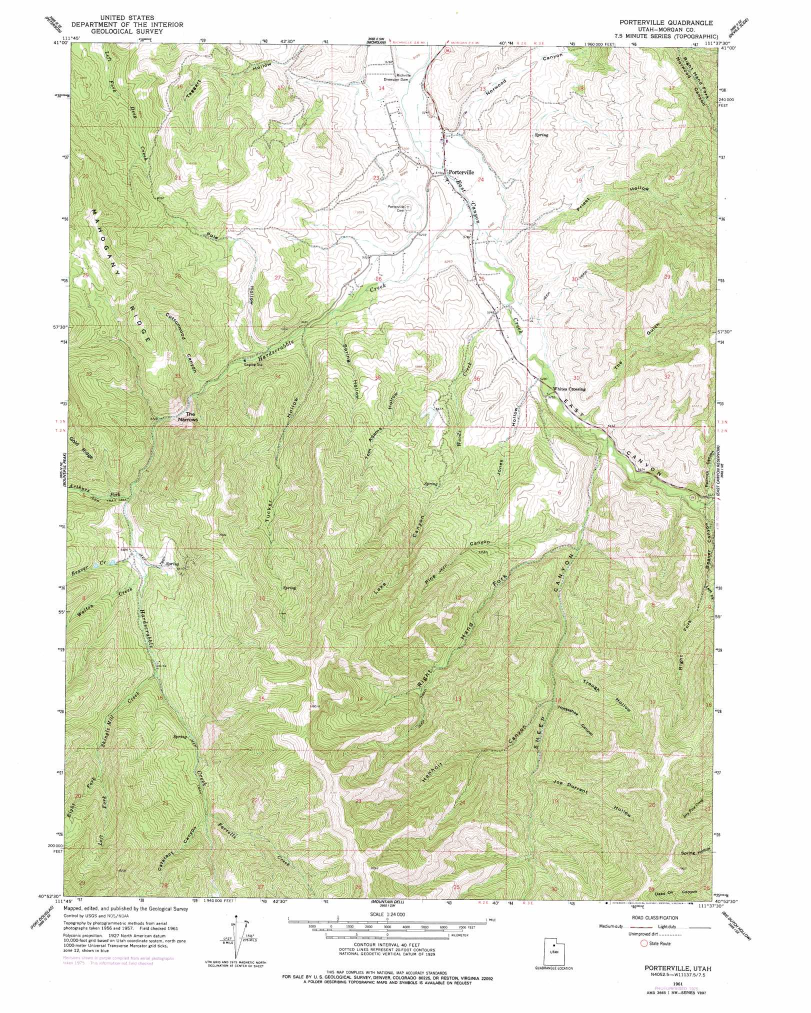
Porterville Topo Map Utah
To zoom in, hover over the map of Porterville
USGS Topo Quad 40111h6 - 1:24,000 scale
| Topo Map Name: | Porterville |
| USGS Topo Quad ID: | 40111h6 |
| Print Size: | ca. 21 1/4" wide x 27" high |
| Southeast Coordinates: | 40.875° N latitude / 111.625° W longitude |
| Map Center Coordinates: | 40.9375° N latitude / 111.6875° W longitude |
| U.S. State: | UT |
| Filename: | o40111h6.jpg |
| Download Map JPG Image: | Porterville topo map 1:24,000 scale |
| Map Type: | Topographic |
| Topo Series: | 7.5´ |
| Map Scale: | 1:24,000 |
| Source of Map Images: | United States Geological Survey (USGS) |
| Alternate Map Versions: |
Porterville UT 1961, updated 1963 Download PDF Buy paper map Porterville UT 1961, updated 1972 Download PDF Buy paper map Porterville UT 1961, updated 1978 Download PDF Buy paper map Porterville UT 1998, updated 2000 Download PDF Buy paper map Porterville UT 2011 Download PDF Buy paper map Porterville UT 2014 Download PDF Buy paper map |
| FStopo: | US Forest Service topo Porterville is available: Download FStopo PDF Download FStopo TIF |
1:24,000 Topo Quads surrounding Porterville
Ogden |
Snow Basin |
Durst Mountain |
Bybee Knoll |
Lost Creek Dam |
Kaysville |
Peterson |
Morgan |
Devils Slide |
Henefer |
Farmington |
Bountiful Peak |
Porterville |
East Canyon Reservoir |
Coalville |
Salt Lake City North |
Fort Douglas |
Mountain Dell |
Big Dutch Hollow |
Wanship |
Salt Lake City South |
Sugar House |
Mount Aire |
Park City West |
Park City East |
> Back to 40111e1 at 1:100,000 scale
> Back to 40110a1 at 1:250,000 scale
> Back to U.S. Topo Maps home
Porterville topo map: Gazetteer
Porterville: Dams
Richville Diversion Dam elevation 1563m 5127′Porterville: Gaps
The Narrows elevation 1785m 5856′Porterville: Populated Places
Porterville elevation 1570m 5150′Whites Crossing elevation 1604m 5262′
Porterville: Ridges
Mahogany Ridge elevation 2077m 6814′Porterville: Streams
Arthurs Fork elevation 1780m 5839′Beaver Creek elevation 1809m 5935′
Farrells Creek elevation 2025m 6643′
Hardscrabble Creek elevation 1574m 5164′
Left Fork Shingle Mill Creek elevation 2060m 6758′
Right Fork Shingle Mill Creek elevation 2060m 6758′
Shingle Mill Creek elevation 1883m 6177′
Walton Creek elevation 1820m 5971′
Woods Creek elevation 1585m 5200′
Porterville: Valleys
Beaver Canyon elevation 1649m 5410′Blue Bell Hollow elevation 1955m 6414′
Cataract Canyon elevation 2025m 6643′
Cottonwood Canyon elevation 1715m 5626′
East Canyon elevation 1579m 5180′
Henholt Canyon elevation 1789m 5869′
Horseshoe Canyon elevation 1795m 5889′
Joe Durrant Hollow elevation 1853m 6079′
Jones Hollow elevation 1600m 5249′
Lake Canyon elevation 1602m 5255′
Left Fork Beaver Canyon elevation 1817m 5961′
Norwood Canyon elevation 1578m 5177′
Pine Canyon elevation 1667m 5469′
Pole Hollow elevation 1671m 5482′
Priest Hollow elevation 1598m 5242′
Redrock Canyon elevation 1656m 5433′
Right Fork Beaver Canyon elevation 1817m 5961′
Right Hand Fork Sheep Canyon elevation 1675m 5495′
Sheep Canyon elevation 1616m 5301′
Spring Hollow elevation 1655m 5429′
The Gulch elevation 1633m 5357′
Tom Adams Hollow elevation 1660m 5446′
Trough Hollow elevation 1768m 5800′
Tucker Hollow elevation 1657m 5436′
Porterville digital topo map on disk
Buy this Porterville topo map showing relief, roads, GPS coordinates and other geographical features, as a high-resolution digital map file on DVD: