Boulter Peak Topo Map Utah
To zoom in, hover over the map of Boulter Peak
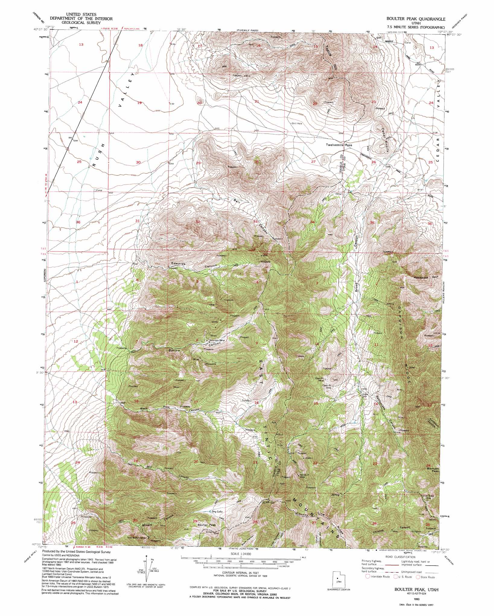
USGS Topo Quad 40112a2 - 1:24,000 scale
| Topo Map Name: | Boulter Peak |
| USGS Topo Quad ID: | 40112a2 |
| Print Size: | ca. 21 1/4" wide x 27" high |
| Southeast Coordinates: | 40° N latitude / 112.125° W longitude |
| Map Center Coordinates: | 40.0625° N latitude / 112.1875° W longitude |
| U.S. State: | UT |
| Filename: | o40112a2.jpg |
| Download Map JPG Image: | Boulter Peak topo map 1:24,000 scale |
| Map Type: | Topographic |
| Topo Series: | 7.5´ |
| Map Scale: | 1:24,000 |
| Source of Map Images: | United States Geological Survey (USGS) |
| Alternate Map Versions: |
Boulter Peak UT 1947, updated 1958 Download PDF Buy paper map Boulter Peak UT 1947, updated 1970 Download PDF Buy paper map Boulter Peak UT 1993, updated 1993 Download PDF Buy paper map Boulter Peak UT 2011 Download PDF Buy paper map Boulter Peak UT 2014 Download PDF Buy paper map |
1:24,000 Topo Quads surrounding Boulter Peak
Saint John |
Ophir |
Mercur |
Cedar Fort |
Saratoga Springs |
Faust |
Vernon Ne |
Fivemile Pass |
Goshen Pass |
Soldiers Pass |
Vernon |
Lofgreen |
Boulter Peak |
Allens Ranch |
Goshen Valley North |
Dutch Peak |
Sabie Mountain |
Tintic Junction |
Eureka |
Goshen |
Cherry Creek |
Maple Peak |
Mcintyre |
Tintic Mountain |
Slate Jack Canyon |
> Back to 40112a1 at 1:100,000 scale
> Back to 40112a1 at 1:250,000 scale
> Back to U.S. Topo Maps home
Boulter Peak topo map: Gazetteer
Boulter Peak: Gaps
Twelvemile Pass elevation 1616m 5301′Boulter Peak: Lakes
Dry Lake elevation 2383m 7818′Boulter Peak: Mines
Hot Stuff Mine elevation 2141m 7024′New Bullion Mine elevation 2211m 7253′
Scranton Mine elevation 2014m 6607′
Silver Dollar Mine elevation 2078m 6817′
Boulter Peak: Ridges
Gardison Ridge elevation 2130m 6988′Rattlesnake Spur elevation 1812m 5944′
Boulter Peak: Summits
Bismark Peak elevation 2450m 8038′Boulter Peak elevation 2530m 8300′
Cedar Knolls elevation 1613m 5291′
Boulter Peak: Valleys
Barlow Canyon elevation 1811m 5941′Bell Canyon elevation 1652m 5419′
Black Rock Canyon elevation 1835m 6020′
Broad Canyon elevation 1632m 5354′
Edwards Canyon elevation 1708m 5603′
Mill Canyon elevation 1916m 6286′
Miners Canyon elevation 1937m 6354′
Rattlesnake Canyon elevation 1829m 6000′
Boulter Peak digital topo map on disk
Buy this Boulter Peak topo map showing relief, roads, GPS coordinates and other geographical features, as a high-resolution digital map file on DVD: