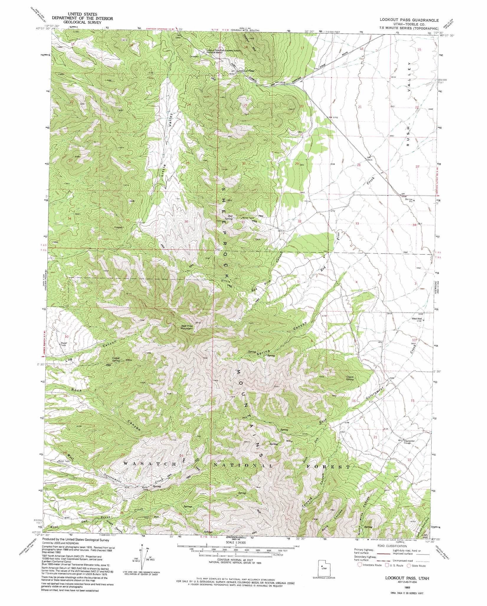
Lookout Pass Topo Map Utah
To zoom in, hover over the map of Lookout Pass
USGS Topo Quad 40112a5 - 1:24,000 scale
| Topo Map Name: | Lookout Pass |
| USGS Topo Quad ID: | 40112a5 |
| Print Size: | ca. 21 1/4" wide x 27" high |
| Southeast Coordinates: | 40° N latitude / 112.5° W longitude |
| Map Center Coordinates: | 40.0625° N latitude / 112.5625° W longitude |
| U.S. State: | UT |
| Filename: | o40112a5.jpg |
| Download Map JPG Image: | Lookout Pass topo map 1:24,000 scale |
| Map Type: | Topographic |
| Topo Series: | 7.5´ |
| Map Scale: | 1:24,000 |
| Source of Map Images: | United States Geological Survey (USGS) |
| Alternate Map Versions: |
Lookout Pass UT 1971, updated 1974 Download PDF Buy paper map Lookout Pass UT 1993, updated 1993 Download PDF Buy paper map Lookout Pass UT 1998, updated 2002 Download PDF Buy paper map Lookout Pass UT 2011 Download PDF Buy paper map Lookout Pass UT 2014 Download PDF Buy paper map |
| FStopo: | US Forest Service topo Lookout Pass is available: Download FStopo PDF Download FStopo TIF |
1:24,000 Topo Quads surrounding Lookout Pass
Tabbys Peak Se |
Terra |
Johnson Pass |
Saint John |
Ophir |
Camels Back Ridge Ne |
Davis Knolls |
Onaqui Mountains South |
Faust |
Vernon Ne |
Simpson Springs |
Indian Peaks |
Lookout Pass |
Vernon |
Lofgreen |
Coyote Springs |
Indian Springs |
Erickson Knoll |
Dutch Peak |
Sabie Mountain |
Keg Mountain Ranch |
Erickson Wash Sw |
Desert Mountain Pass |
Cherry Creek |
Maple Peak |
> Back to 40112a1 at 1:100,000 scale
> Back to 40112a1 at 1:250,000 scale
> Back to U.S. Topo Maps home
Lookout Pass topo map: Gazetteer
Lookout Pass: Flats
Stepladder Trough elevation 1857m 6092′Lookout Pass: Gaps
Lookout Pass elevation 1888m 6194′Lookout Pass: Springs
Copper Spring elevation 2003m 6571′Coyote Spring elevation 1895m 6217′
Hill Spring elevation 2001m 6564′
Lookout Pass: Streams
South Fork East Government Creek elevation 1939m 6361′Lookout Pass: Summits
Red Pine Mountain elevation 2571m 8435′Lookout Pass: Valleys
Little Red Pine Canyon elevation 1816m 5958′Log Canyon elevation 1827m 5994′
Middle Canyon elevation 1897m 6223′
North Pine Canyon elevation 2004m 6574′
Rock Canyon elevation 2092m 6863′
Spring Canyon elevation 1805m 5921′
Talawag Canyon elevation 2013m 6604′
Lookout Pass: Wells
West Well elevation 1751m 5744′Lookout Pass digital topo map on disk
Buy this Lookout Pass topo map showing relief, roads, GPS coordinates and other geographical features, as a high-resolution digital map file on DVD: