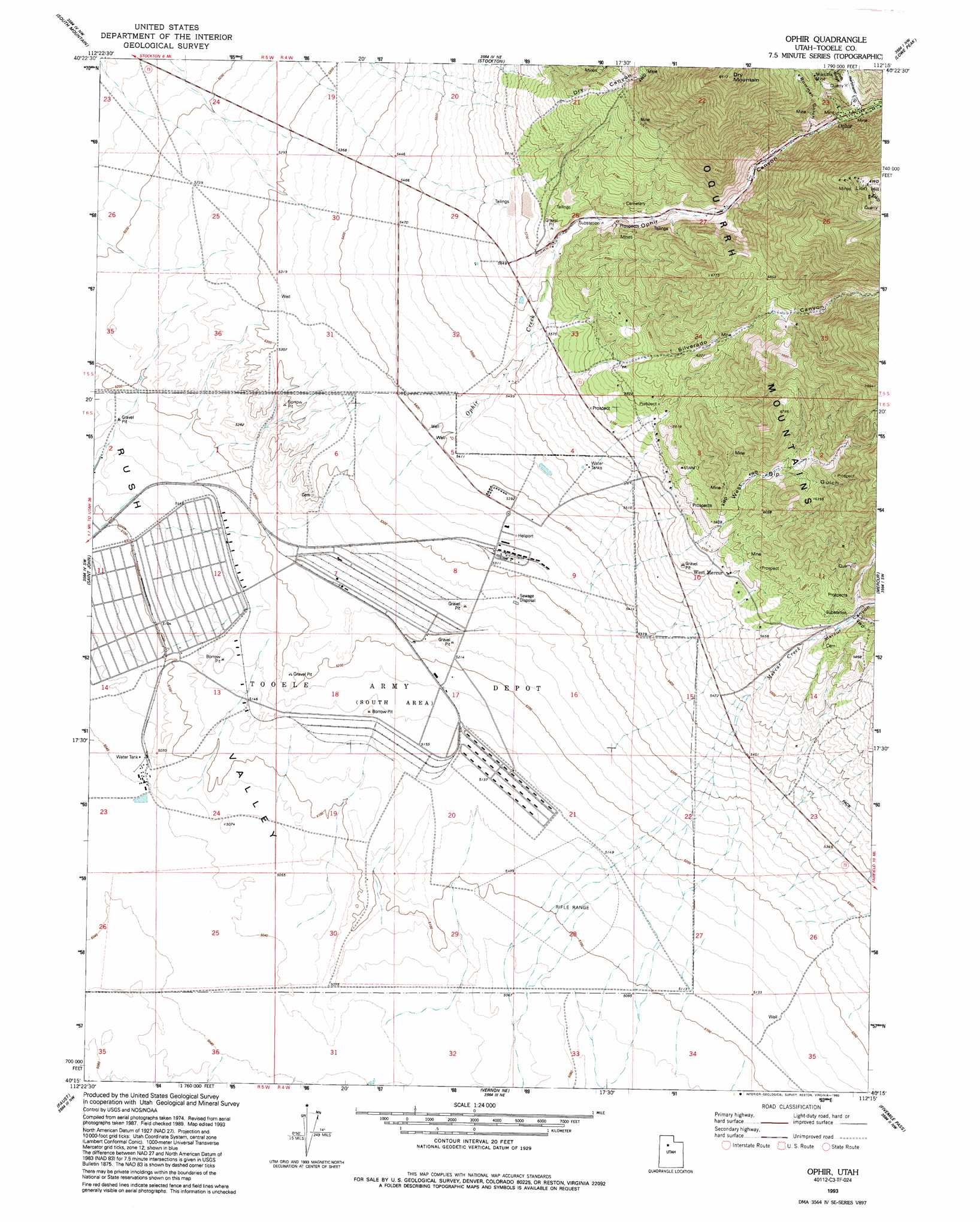
Ophir Topo Map Utah
To zoom in, hover over the map of Ophir
USGS Topo Quad 40112c3 - 1:24,000 scale
| Topo Map Name: | Ophir |
| USGS Topo Quad ID: | 40112c3 |
| Print Size: | ca. 21 1/4" wide x 27" high |
| Southeast Coordinates: | 40.25° N latitude / 112.25° W longitude |
| Map Center Coordinates: | 40.3125° N latitude / 112.3125° W longitude |
| U.S. State: | UT |
| Filename: | o40112c3.jpg |
| Download Map JPG Image: | Ophir topo map 1:24,000 scale |
| Map Type: | Topographic |
| Topo Series: | 7.5´ |
| Map Scale: | 1:24,000 |
| Source of Map Images: | United States Geological Survey (USGS) |
| Alternate Map Versions: |
Ophir UT 1980, updated 1980 Download PDF Buy paper map Ophir UT 1980, updated 1980 Download PDF Buy paper map Ophir UT 1993, updated 1993 Download PDF Buy paper map Ophir UT 2011 Download PDF Buy paper map Ophir UT 2014 Download PDF Buy paper map |
1:24,000 Topo Quads surrounding Ophir
North Willow Canyon |
Grantsville |
Tooele |
Bingham Canyon |
Lark |
Deseret Peak East |
South Mountain |
Stockton |
Lowe Peak |
Tickville Spring |
Johnson Pass |
Saint John |
Ophir |
Mercur |
Cedar Fort |
Onaqui Mountains South |
Faust |
Vernon Ne |
Fivemile Pass |
Goshen Pass |
Lookout Pass |
Vernon |
Lofgreen |
Boulter Peak |
Allens Ranch |
> Back to 40112a1 at 1:100,000 scale
> Back to 40112a1 at 1:250,000 scale
> Back to U.S. Topo Maps home
Ophir topo map: Gazetteer
Ophir: Mines
Montana Mine elevation 2140m 7020′Ophir: Populated Places
Ophir elevation 1980m 6496′West Mercur elevation 1727m 5666′
Ophir: Streams
Mercur Creek elevation 1678m 5505′Ophir Creek elevation 1610m 5282′
Ophir: Summits
Dry Mountain elevation 2553m 8375′Ophir: Valleys
Bowman Gulch elevation 1947m 6387′Dry Canyon elevation 1782m 5846′
Hartmann Gulch elevation 2027m 6650′
Mercur Canyon elevation 1678m 5505′
Ophir Canyon elevation 1717m 5633′
Silverado Canyon elevation 1730m 5675′
West Dip Gulch elevation 1743m 5718′
Ophir: Wells
Gillmore Well elevation 1567m 5141′Ophir digital topo map on disk
Buy this Ophir topo map showing relief, roads, GPS coordinates and other geographical features, as a high-resolution digital map file on DVD: