Bingham Canyon Topo Map Utah
To zoom in, hover over the map of Bingham Canyon
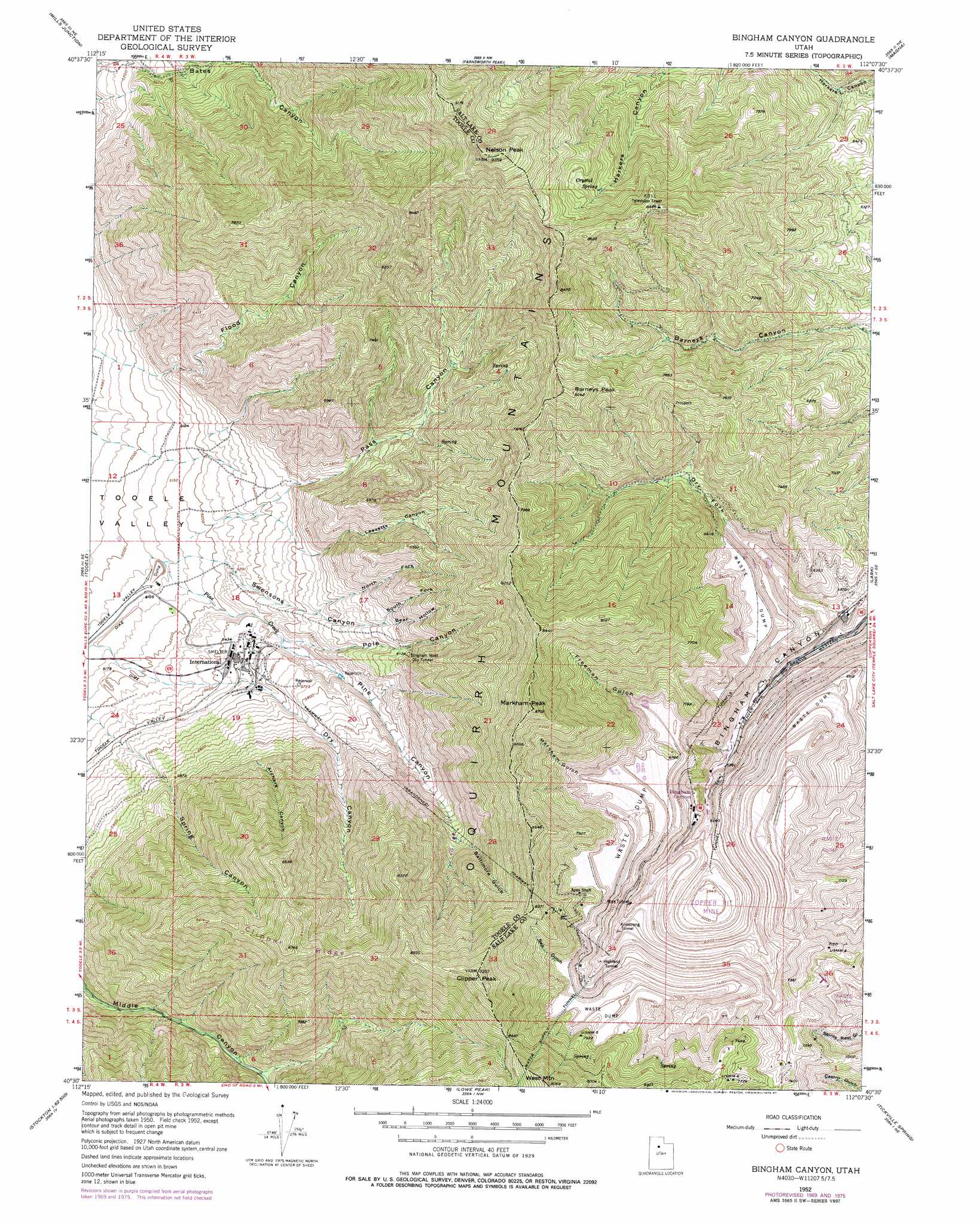
USGS Topo Quad 40112e2 - 1:24,000 scale
| Topo Map Name: | Bingham Canyon |
| USGS Topo Quad ID: | 40112e2 |
| Print Size: | ca. 21 1/4" wide x 27" high |
| Southeast Coordinates: | 40.5° N latitude / 112.125° W longitude |
| Map Center Coordinates: | 40.5625° N latitude / 112.1875° W longitude |
| U.S. State: | UT |
| Filename: | o40112e2.jpg |
| Download Map JPG Image: | Bingham Canyon topo map 1:24,000 scale |
| Map Type: | Topographic |
| Topo Series: | 7.5´ |
| Map Scale: | 1:24,000 |
| Source of Map Images: | United States Geological Survey (USGS) |
| Alternate Map Versions: |
Bingham Canyon UT 1952, updated 1954 Download PDF Buy paper map Bingham Canyon UT 1952, updated 1963 Download PDF Buy paper map Bingham Canyon UT 1952, updated 1971 Download PDF Buy paper map Bingham Canyon UT 1952, updated 1978 Download PDF Buy paper map Bingham Canyon UT 1952, updated 1987 Download PDF Buy paper map Bingham Canyon UT 1997, updated 2002 Download PDF Buy paper map Bingham Canyon UT 2011 Download PDF Buy paper map Bingham Canyon UT 2014 Download PDF Buy paper map |
1:24,000 Topo Quads surrounding Bingham Canyon
Plug Peak |
Plug Peak Se |
Antelope Island South |
Saltair |
Salt Lake City North |
Burmester |
Mills Junction |
Farnsworth Peak |
Magna |
Salt Lake City South |
Grantsville |
Tooele |
Bingham Canyon |
Lark |
Midvale |
South Mountain |
Stockton |
Lowe Peak |
Tickville Spring |
Jordan Narrows |
Saint John |
Ophir |
Mercur |
Cedar Fort |
Saratoga Springs |
> Back to 40112e1 at 1:100,000 scale
> Back to 40112a1 at 1:250,000 scale
> Back to U.S. Topo Maps home
Bingham Canyon topo map: Gazetteer
Bingham Canyon: Dams
Anaconda Tailing Dam elevation 1560m 5118′Bingham Canyon: Mines
Apex Shaft elevation 2326m 7631′Apex Tunnel elevation 1996m 6548′
Armstrong Tunnel elevation 2063m 6768′
Bingham Copper Mine elevation 1696m 5564′
Bingham West Dip Tunnel elevation 1868m 6128′
Highland Tunnel elevation 2118m 6948′
Bingham Canyon: Ranges
Oquirrh Mountains elevation 2300m 7545′Bingham Canyon: Reservoirs
Anaconda Reservoir elevation 1560m 5118′Bingham Canyon: Ridges
Clipper Ridge elevation 2624m 8608′Bingham Canyon: Springs
Crystal Spring elevation 2375m 7791′Bingham Canyon: Streams
Pine Creek elevation 1536m 5039′Bingham Canyon: Summits
Barneys Peak elevation 2508m 8228′Clipper Peak elevation 2805m 9202′
Curry Peak elevation 2265m 7431′
Freeman Peak elevation 2623m 8605′
Markham Peak elevation 2641m 8664′
Nelson Peak elevation 2829m 9281′
West Mountain elevation 2744m 9002′
Bingham Canyon: Valleys
Archers Canyon elevation 1877m 6158′Baltimore Gulch elevation 2010m 6594′
Bear Hollow elevation 1840m 6036′
Dry Canyon elevation 1557m 5108′
Dry Fork Bingham Canyon elevation 1733m 5685′
Flood Canyon elevation 1554m 5098′
Freeman Gulch elevation 2104m 6902′
Leavetts Canyon elevation 1697m 5567′
Markham Gulch elevation 2218m 7276′
North Fork Swensons Canyon elevation 1724m 5656′
Pass Canyon elevation 1572m 5157′
Pine Canyon elevation 1557m 5108′
Pole Canyon elevation 1665m 5462′
Sap Gulch elevation 2261m 7417′
South Fork Swensons Canyon elevation 1840m 6036′
Spring Canyon elevation 1647m 5403′
Swensons Canyon elevation 1593m 5226′
Bingham Canyon digital topo map on disk
Buy this Bingham Canyon topo map showing relief, roads, GPS coordinates and other geographical features, as a high-resolution digital map file on DVD: